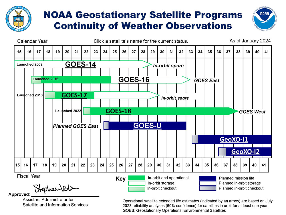
Mission Overview
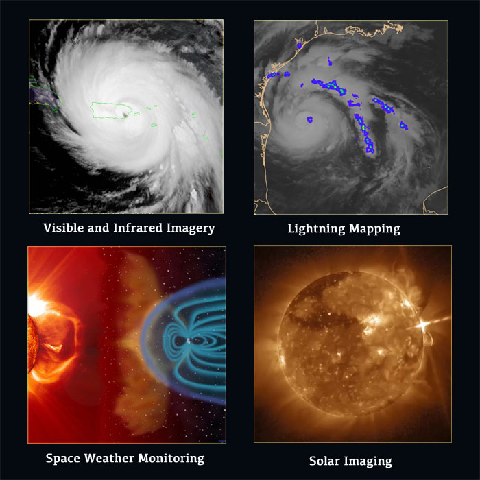
Visible and Infrared Imagery | Lightning Mapping | Space Weather Monitoring | Solar Imaging
NOAA’s latest generation of Geostationary Operational Environmental Satellites (GOES), known as the GOES-R Series, is the nation’s most advanced fleet of geostationary weather satellites. Geostationary satellites circle the Earth in geosynchronous orbit, which means they orbit the Earth’s equatorial plane at a speed matching the Earth’s rotation. This allows them to stay in a fixed position in the sky, remaining stationary with respect to a point on the ground. GOES satellites continually view the Western Hemisphere from approximately 22,300 miles above Earth. GOES satellites are designated with a letter prior to launch and renamed with a number once they reach geostationary orbit.
The GOES-R Series is a four-satellite program including GOES-R, GOES-S, GOES-T and GOES-U. The GOES-R Series is a National Oceanic and Atmospheric Administration (NOAA) mission, supported by the National Aeronautics and Space Administration (NASA). NOAA manages the GOES-R Series Program through an integrated NOAA-NASA office, with personnel from both agencies. NASA’s Goddard Space Flight Center oversees the acquisition of the GOES-R spacecraft and instruments and NASA’s Kennedy Space Center manages launch services. NOAA manages the ground system, operates the satellites, and distributes their data to users worldwide.
The GOES-R Series provides advanced imagery and atmospheric measurements of Earth’s weather, oceans and environment, real-time mapping of total lightning activity, and improved monitoring of solar activity and space weather.
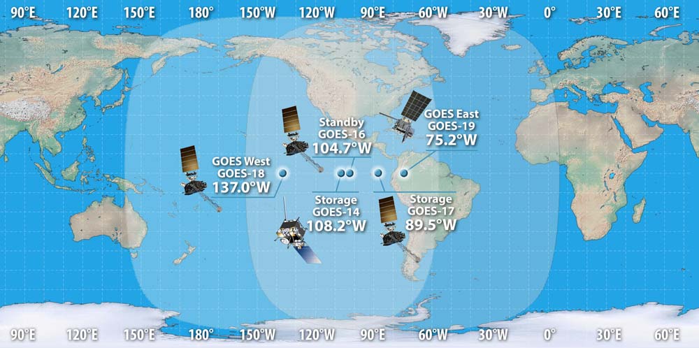
The GOES-R Series maintains the two-satellite operational system implemented by the previous GOES satellites. However, the locations of the operational GOES-R Series satellites are 75.2⁰ W and 137.2⁰ W, instead of 75⁰ W and 135⁰ W. These shifts eliminate conflicts with other satellite systems. NOAA also maintains an on-orbit spare GOES satellite at 105⁰ W in the event of an anomaly or failure of GOES East or GOES West. The GOES History page of this site provides a look back at the GOES program.
BENEFITS AND APPLICATIONS
- Hurricane track and intensity forecasts
- Early warning of severe storms and tornadoes
- Fire detection, monitoring, and intensity estimation
- Identification of lightning strikes most likely to ignite fires
- Detection of low clouds and fog
- Monitoring of atmospheric river events that can cause flooding and mudslides
- Monitoring of smoke, dust and aerosols
- Data for air quality warnings and alerts
- Data for aviation route planning and reducing weather-related flight delays
- Detection of volcanic eruptions and monitoring of ash and sulfur dioxide
- Detection of heavy rainfall and flash flood risks.
- Sea surface temperature data for monitoring fisheries and marine life
- Monitoring of vegetative health
- Data for long-term climate variability studies
- Detection of meteors entering Earth’s atmosphere
- Detection of coronal holes, solar flares, and coronal mass ejection source regions
- Warning of space weather hazards responsible for communications and navigation disruptions and power blackouts
- Monitoring of energetic particles responsible for radiation hazards
The GOES-R Series also continues the legacy Geostationary SAR (GEOSAR) function of the SARSAT system onboard NOAA’s GOES satellites which has contributed to the rescue of thousands of individuals in distress. The GOES-R Series SARSAT transponder operates with a lower uplink power than the previous system, enabling GOES-R Series satellites to detect weaker beacon signals.
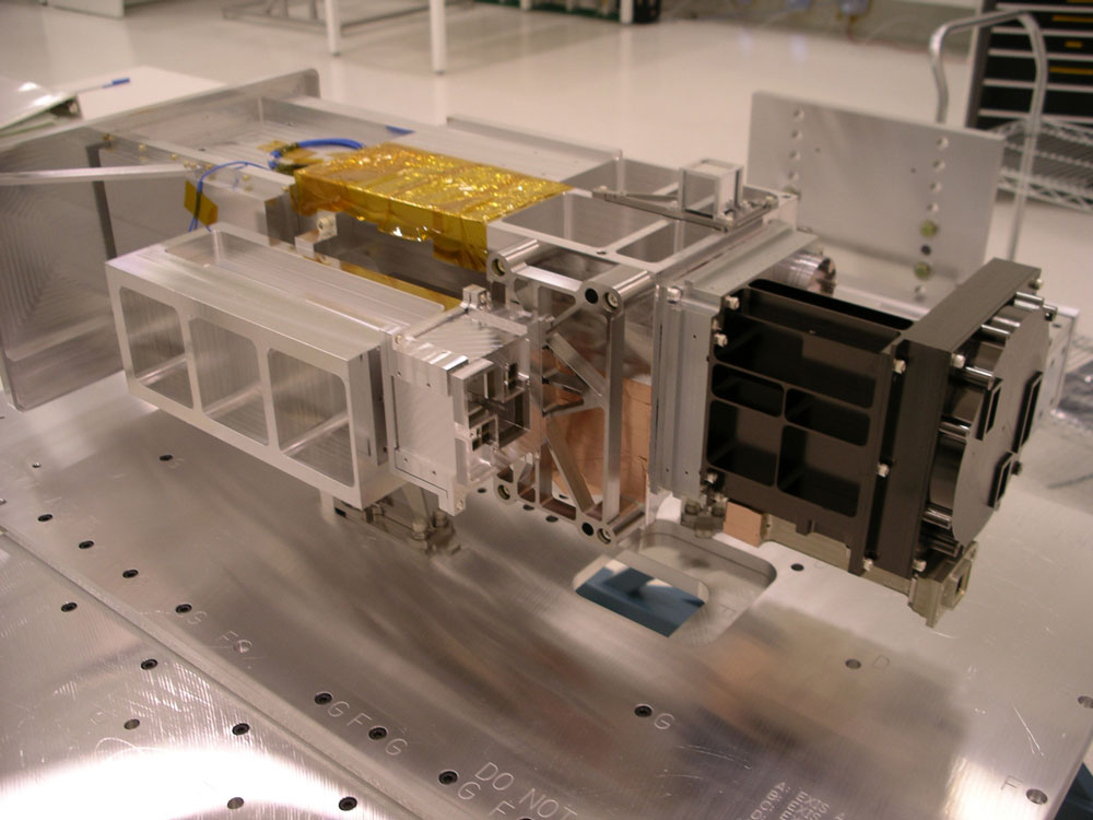
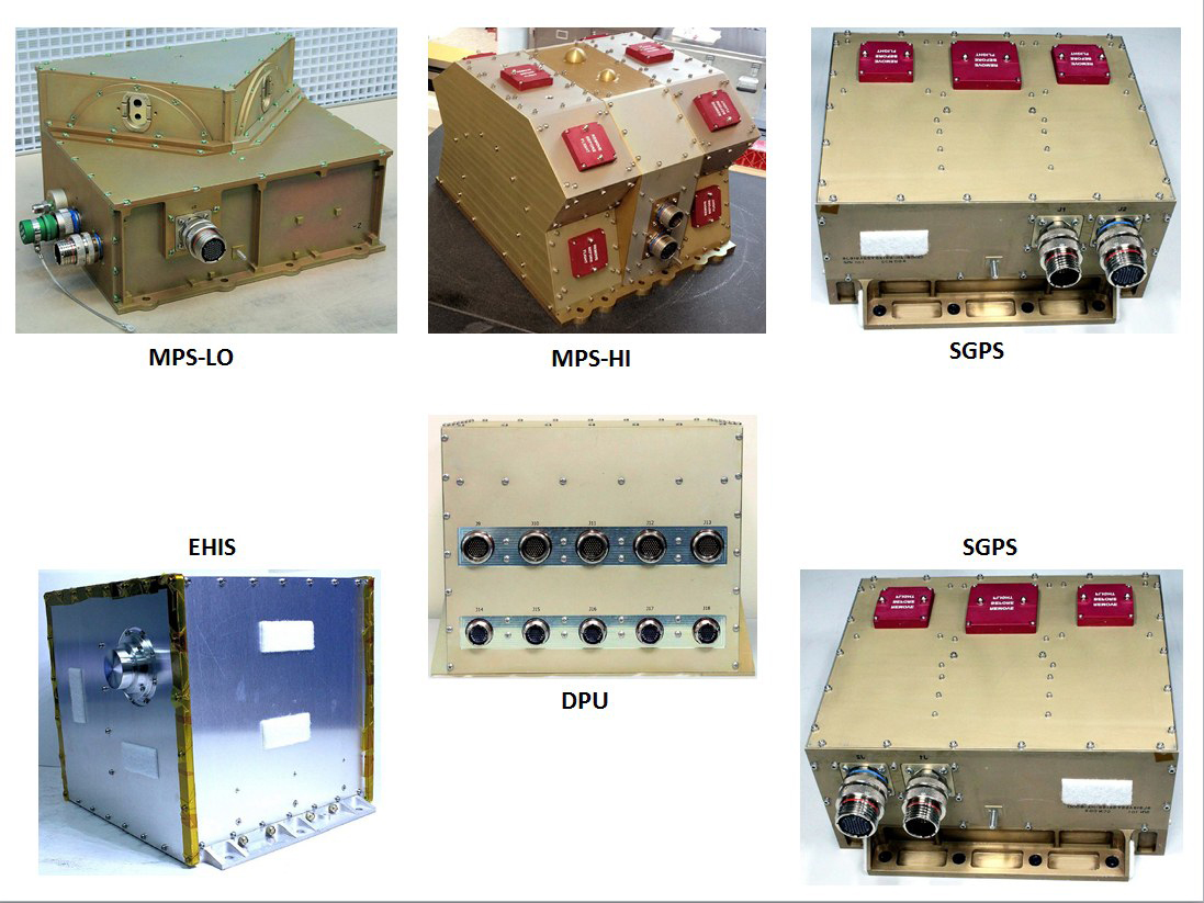
INSTRUMENT SUITES
Click the instrument name to go to the instrument page, expand the image using the magnifying glass or click the image to load a higher resolution image in a new window.
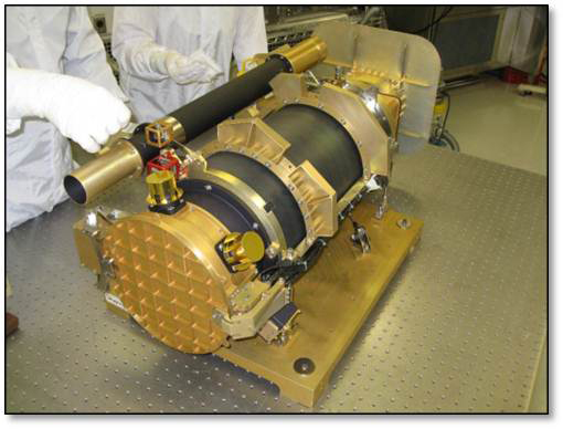
Advanced Baseline Imager
The Advanced Baseline Imager is the primary instrument for imaging Earth’s weather, oceans and environment. ABI views Earth with three times more spectral channels, four times the resolution, and five times faster scanning that previous GOES.
Extreme Ultraviolet X-Ray Irradiance Sensor
The Extreme Ultraviolet and X-ray Irradiance Sensors detect and monitor solar irradiance in the upper atmosphere. EXIS is able to detect solar flares that could interrupt communications and reduce navigational accuracy, affecting satellites, high altitude airlines and power grids on Earth.
Geostationary Lightning Mapper
The Geostationary Lightning Mapper is the first operational lightning mapper in geostationary orbit. GLM detects the light emitted by lightning at the tops of clouds day and night. The instrument is sensitive to the in-cloud lightning that is most dominant in severe thunderstorms and provides nearly-uniform total lightning coverage over the region of interest.
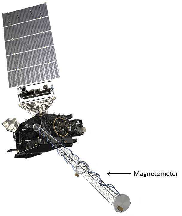
Magnetometer
The Magnetometer provides measurements of the space environment magnetic field that controls charged particle dynamics in the outer region of the magnetosphere. These particles can be dangerous to spacecraft and human spaceflight.
Space Environmental In-Situ Suite
The Space Environment In-Situ Suite is an array of sensors that monitor proton, electron, and heavy ion fluxes in the magnetosphere. Information provided by SEISS is used for assessing radiation hazards to astronauts and satellites and to warn of high flux events.
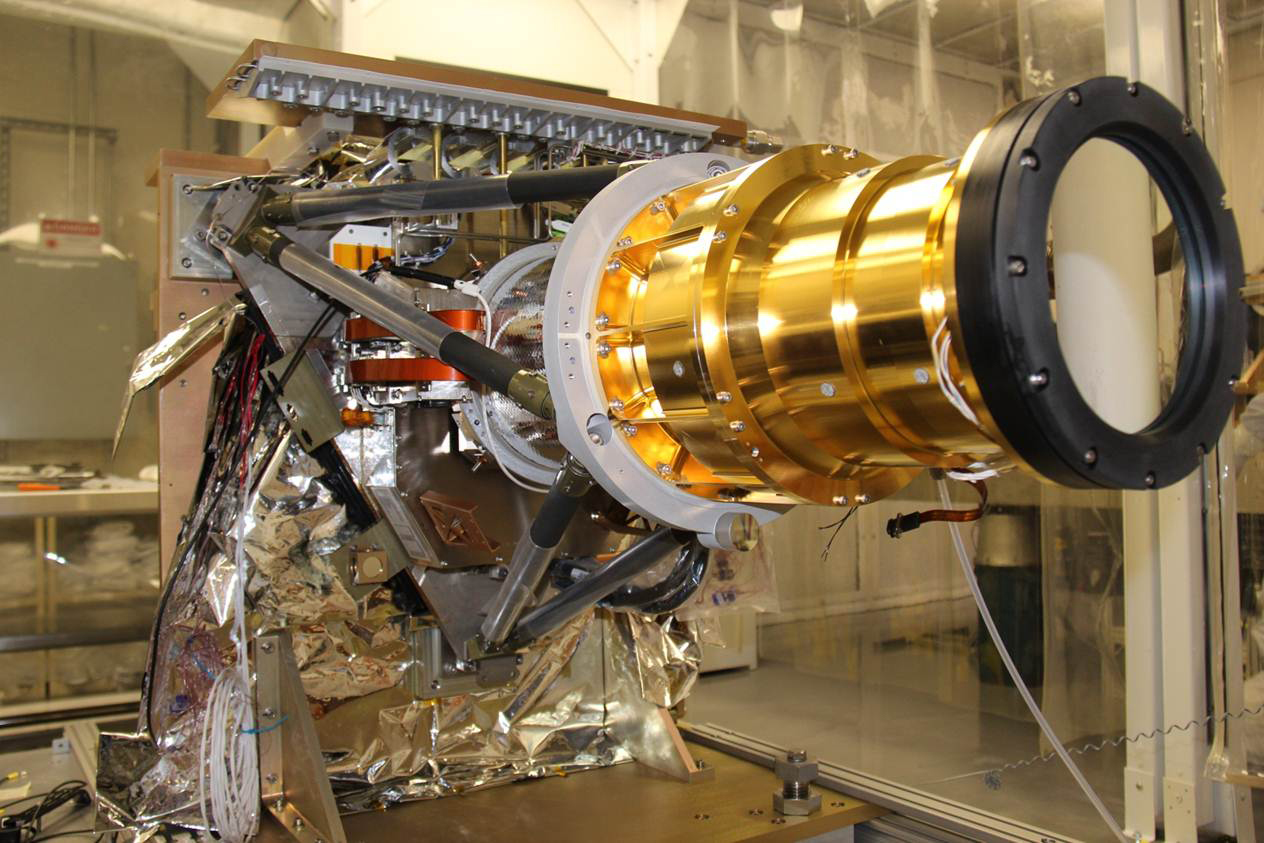
Solar Ultraviolet Imager
The Solar Ultraviolet Imager is a telescope that observes and characterizes complex active regions of the sun, solar flares, and eruptions of solar filaments that may give rise to coronal mass ejections. SUVI data enables improved forecasting of space weather and early warnings of possible impacts to the Earth environment.
GOES-R (GOES-16)
GOES-R, now GOES-16, launched from Space Launch Complex 41 at Cape Canaveral Air Force Station, Florida, aboard an Atlas V 541 rocket on November 19, 2016 at 6:42 p.m. EST. GOES-16 replaced GOES-13 as NOAA’s operational GOES East satellite on December 18, 2017. GOES-16 served as GOES East until April 7, 2025, when it was replaced by GOES-19. GOES-16 now serves as the primary on-orbit back up for GOES East and GOES West.
GOES-S (GOES-17)
GOES-S, now GOES-17, launched on March 1, 2018, at 5:02 p.m. EST from Space Launch Complex 41 at Cape Canaveral Air Force Station, Florida aboard an Atlas V 541 rocket. GOES-17 replaced GOES-15 as NOAA’s operational GOES West at 137.2 degrees west longitude over the Pacific Ocean on February 12, 2019 and served as GOES West until January 4, 2023, when it was replaced by GOES-18.
GOES-T (GOES-18)
GOES-T, now GOES-18, launched on March 1, 2022, at 4:38 p.m. EST from Space Launch Complex 41 at Cape Canaveral Space Force Station, Florida, aboard an Atlas V 541 rocket. GOES-18 became the operational GOES West satellite at 137.0 degrees west longitude on January 4, 2023, replacing GOES-17. As GOES West, GOES-18 is in position to watch over the western contiguous United States, Alaska, Hawaii, Mexico, Central America, and the Pacific Ocean to New Zealand.
GOES-U (GOES-19)
GOES-U, now GOES-19, launched on June 25, 2024, at 5:26 p.m. EDT from NASA’s Kennedy Space Center aboard a Falcon Heavy rocket. GOES-19 replaced GOES-16 as NOAA’s operational GOES East satellite on April 7, 2025. As GOES East, GOES-19 keeps watch over North and South America and the Atlantic Ocean all the way to the west coast of Africa.