User Systems: GOES Rebroadcast
Type of Transmission: Direct Broadcast
Users: Anyone with an antenna and software capable of receiving GOES direct broadcast downlink
What should I know about GOES Rebroadcast?
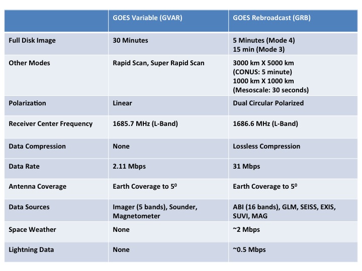
GOES Rebroadcast (GRB) provides the primary relay of full resolution, calibrated, near-real-time direct broadcast space relay of Level 1b data from each instrument and Level 2 data from the Geostationary Lightning Mapper (GLM). GRB replaced the GOES VARiable (GVAR) service. GRB contains the ABI, GLM, space environment, and solar data which drive data flow in the NOAA space and Earth environment research and operational framework. Additional information is available in the Product Users’ Guide.
GRB uses two digital streams, each at 15.5 Mbps, compared to the GVAR standard of a single 2.11 Mbps stream. A dual polarization approach is used to accommodate the 31 Mbps data rate within a frequency bandwidth of 9.8 or 10.9 MHz per polarization, using a standard downlink modulation at 1686.6 MHz (L-band). GRB produces a full disk image in either five or fifteen minutes, depending on mode, compared to GVAR’s thirty minutes. Additional technical information regarding data downlink can be found in the GRB downlink specifications document.
The GRB processed instrument data source is packetized compliant with Consultative Committee for Space Data Systems (CCSDS) standard 133.0-B-l and utilizes lossless data compression to fit within allocated bandwidth. Data blocking and accompanying header metadata is used to minimize risk of loss due to link errors and allow for user verification of data integrity.
GRB distributes the full set of level 1b products, including data from all ABI channels and the other GOES-R Series instruments (GLM, MAG, SEISS, SUVI, EXIS, and Magnetometer).
GOES users must upgrade or acquire new antenna and receiver hardware, and acquire processing systems in order to receive the higher volume of GOES-R Series data via GRB.