GOES-R Series Unique Payload Services (UPS)
The GOES-R Series Unique Payload Services suite consists of transponder payloads providing communications relay services in addition to the primary GOES mission data. The UPS suite consists of the Data Collection System (DCS), the High Rate information Transmission/Emergency Managers Weather Information Network (HRIT/EMWIN), GOES Rebroadcast (GRB), and the Search and Rescue Satellite-Aided Tracking (SARSAT) system.
GOES Rebroadcast (GRB)
GOES Rebroadcast provides the primary relay of full resolution, calibrated, near-real-time direct broadcast space relay of Level 1b data from each instrument and Level 2 data from the Geostationary Lightning Mapper (GLM). GRB replaces the GOES VARiable (GVAR) service.
GRB uses two digital streams, each at 15.5 Mbps, compared to the GVAR standard of a single 2.11 Mbps stream. A dual polarization approach is used to accommodate the 31 Mbps data rate within a frequency bandwidth of 9.8 or 10.9 MHz per polarization, using a standard downlink modulation at 1686.6 MHz (L-band). Learn more about GOES Rebroadcast in the GRB section of this site.
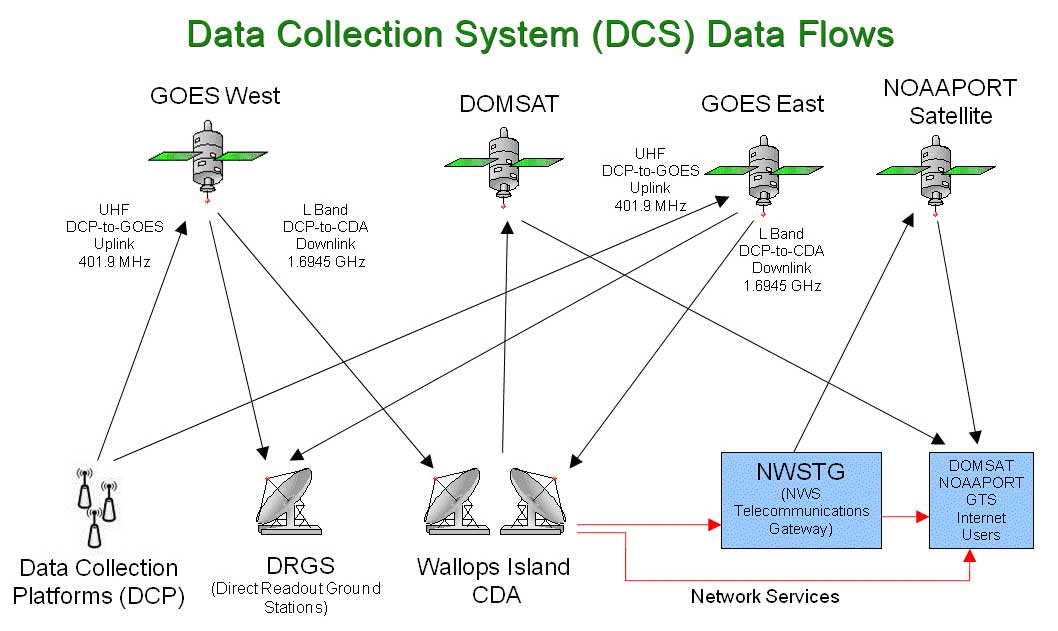
Data Collection System (DCS)
The Data Collection System is a satellite relay system used to collect information from Earth-based data collection platforms that transmit in-situ environmental sensor data, such as stream or river flow, tide-levels, weather conditions, etc. The transmissions can occur on predefined frequencies and schedules, in response to thresholds in sensed conditions, or in response to interrogation signals. The transponder on board GOES satellites detects this signal and then rebroadcasts it so that it can be picked up by other ground-based equipment. Federal, state and local agencies then monitor the environment through the transmission of observations from these surface-based data collection platforms. The platforms can be placed in remote locations and left to operate with minimal human intervention. The Data Collection System thus allows for more frequent and more geographically complete environmental monitoring. In the GOES-R Series era, the number of user-platform channels expanded from 266 to 433. There is also a frequency change from 1696 MHz to 1679 MHz, which requires replacement of users’ Low Noise Block (LNB) feed. Direct Readout Ground Station (DRGS) manufacturers have been informed of this change. Data transmission rates in the GOES-R Series era are 300 bps and 1200 bps. There is no change to the data access policy.
For more information about the DCS visit the NOAA DCS web page.
Emergency Managers Weather Information Network (EMWIN)
The Emergency Managers Weather Information Network (EMWIN) is a direct service that provides users with weather forecasts, warnings, graphics, and other information directly from the National Weather Service (NWS) in near real time. The GOES EMWIN relay service is one of a suite of methods to obtain these data and display the products on the user’s personal computer. The HRIT service provides broadcast of low-resolution GOES satellite imagery data and selected products to remotely located user HRIT Terminals.
For more information concerning HRIT/EMWIN, please see the HRIT/EMWIN web page in the User Community section of this website.
Search and Rescue Satellite Aided Tracking (SARSAT)
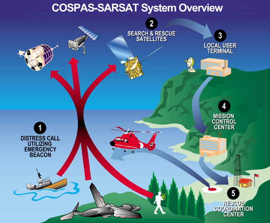
As an integral part of the international search and rescue satellite program called COSPAS-SARSAT, NOAA operates the Search and Rescue Satellite-Aided Tracking (SARSAT) system to detect and locate mariners, aviators, and other recreational users in distress almost anywhere in the world at any time and in almost any condition. This system uses a network of satellites to quickly detect and locate distress signals from emergency beacons onboard aircraft, vessels, and from handheld personal locator beacons called PLBs. The SARSAT transponder on board GOES-R Series satellites provides the capability to immediately detect distress signals from emergency beacons and relay them to ground stations - called local user terminals. In turn, this signal is routed to a SARSAT mission control center and then sent to a rescue coordination center which dispatches a search and rescue team to the location of the distress.
The GOES-R Series continues the legacy Geostationary SAR (GEOSAR) function of the SARSAT system onboard NOAA’s GOES satellites which has contributed to the rescue of thousands of individuals in distress. The SARSAT transponder was modified slightly for the GOES-R Series to operate with a lower uplink power (32 dBm), enabling GOES-R Series satellites to detect weaker signal beacons.
In 2019, 421 people were rescued from life-threatening situations throughout the United States and its surrounding waters by the SARSAT system. For more information about SARSAT, visit the NOAA SARSAT web site and the NASA SAR Mission Office web site.