GOES-18 Post-Launch Testing and Transition to Operations
GOES-T launched on March 1, 2022, and was renamed GOES-18 upon reaching geostationary orbit on March 14.
GOES-18 completed a “split” post-launch testing phase that placed the satellite into position near the current GOES-West location of 137.2 degrees west prior to the completion of post-launch testing. This allowed forecasters to have early access to operational Advanced Baseline Imager (ABI) data after Beta maturity validation during the “warm” periods that degrade GOES-17 imagery during the height of hurricane season.
The drift of GOES-18 from 89.5 degrees west to 136.8 degrees west was completed on June 6, 2022. A slight reconfiguration of the nominal GOES-West orbit location occurred by nudging GOES-17 to the 137.3 degrees west location, providing room for nudging GOES-18 to the 137.0 degrees west location. From this location, GOES-18 will complete the remainder of its product testing and also provide an operational interleave of data. The interleave is the combination of GOES-18 ABI data "interleaved" with GOES-17 non-ABI product data (GLM, space weather instruments) via GOES-17 GOES Rebroadcast (GRB) and Product Distribution and Access (PDA). The first interleave period was completed Aug. 1 – Sept 8, 2022, and the second interleave period occurred Oct. 13 through Nov. 16, 2022.
After completing a successful on-orbit checkout and testing of its instruments and systems, GOES-18 was handed over to the NOAA Office of Satellite and Product Operations in October 2022. The satellite then underwent additional testing of its data products.
GOES-18 went into operational service as GOES-West on Jan. 4, 2023, replacing GOES-17. GOES-17 will now serve as an on-orbit standby for the operational GOES constellation.
GOES-West Transition Plan for Operationalization of GOES-18
Details as of Dec. 13, 2022
Please Note: The following dates are subject to change based on launch, on-orbit checkout activities, and operational needs.
| COLOR KEY: | GOES-West Operational Satellite | GOES-18 ABI data interleaved in GOES-17 data |
Tables scroll horizontally on smaller windows and devices.
| Date (Based on 3/1/22 Launch | GOES-17 | GOES-18 | ||
|---|---|---|---|---|
| Date | Location | Activity | Location | Activity |
| 3/1 – 3/23 | 137.2°W | GOES-West Operations | Launch and Orbit Raising | |
| 3/24 – 5/15 | 89.5°W | GOES-18 PLT Part 1
|
||
| 5/16 – 6/6 | 136.8W | GOES-18 Drift from 89.5W to 136.8W
|
||
| 6/7 | GOES-18 PLT Part 2 begins and PLPT begins | |||
| 7/5 – 7/15 (21) | 137.3°W | Orbit Nudge 137.2W to 137.3W: July 5-15, 2022 (10 days)
|
137.0°W | Orbit Nudge 136.8W to 137.0W: July 5-21, 2022 (16 days)
|
| 7/27 | 137.3°W | 137.0°W | GOES-18 ABI reaches Provisional maturity
|
|
| 8/1-9/8 | 137.3°W | GOES-17 ABI Warm Period
|
137.0°W | GOES-18 ABI data interleaved in GOES-17 GRB |
| 9/8-10/13 | 137.3°W | GOES-West Operations
|
137.0°W | GOES-18 product maturation continues
|
| 10/13-11/16 | 137.3°W | GOES-17 ABI Warm Period
|
137.0°W | GOES-18 ABI data interleaved in GOES-17 GRB |
| 11/16-1/3 | 137.3°W | GOES-West Operations
|
137.0°W | GOES-18 product maturation continues
|
| 1/4 | 137.3°W | X-band downlink off and instruments shut down | 137.0°W | GOES-18 Declared operational GOES-West
|
| 1/12 | 104.7°W | GOES-17 drift to 105°W, followed by storage mode | 137.0°W | |
Product Data Interleaving
The National Weather Service requested that the GOES-R Program distribute Beta GOES-18 ABI products during the August 2022 warm season. Interleaving is a method that allows the GOES-R ground system to merge data from multiple satellites into a single data-processing flow. Data to the AWIPS and GRB uplink can be configured to contain a mixture of data from GOES-17 non-ABI instruments or the GOES-18 ABI. The data will present to the user as a single GOES-West stream.
When interleaving, all product metadata will be maintained so the original source spacecraft designator will remain intact. Users will always be able to determine which satellite generated the data being accessed.
GRB Interleave Spacecraft IDs & Metadata |
|||||
|---|---|---|---|---|---|
| G17 GRB Nominal as GOES-West | G18 GRB Interleaved w/ G16 ABI, G17 non-ABI | G17 GRB Interleaved w/ G18 ABI, G17 non-ABI | G18 GRB Nominal as GOES-West | ||
| Interleave Test Configurations | N/A | GND-006 (May 9, 2022) | GND-009 (May 11, 2022) GND-008 (June 30, 2022) |
N/A | |
| Operational Interleave Periods | N/A | N/A | Aug 1, 2022 - Sep 8, 2022 Oct. 13, 2022 - Nov. 16, 2022 |
N/A | |
| Data Relay | GRB Spacecraft ID (SCID) AOS frame header (8 bits) | 0x82 | 0xE4 | 0x82 | 0xE4 |
| Data Source | platform_ID metadata within ABI packets | G17 | G16 | G18 | G18 |
| instrument_ID metadata within ABI packets | FM2 | FM1 | FM3 | FM3 | |
Updated July 21, 2022
GOES-18 Advanced Baseline Imager (ABI) Band 7 “Barcode Artifact”
Information as of March 7, 2023
Once GOES-18 arrived at 136.8° W in early June 2022, vertically-oriented bars were discovered in some ABI Band 7 (3.9 μm) imagery. The spatial pattern of the artifact is similar in appearance to a barcode.
GOES-18 Band 7 (3.9 µm) has higher noise than Band 7 on GOES-16 and GOES-17. Sometimes, the noise seems to self-organize into north-south oriented bands of warm and cold stripes, known as the “barcode artifact.” The artifact is more visible in images of uniformly cold scenes, animations, and time- or channel-differences such as nighttime cloud microphysics.
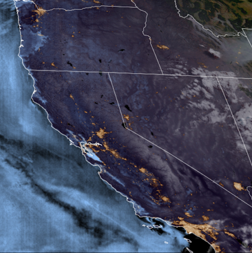
The GOES-18 ABI Band 7 “barcode artifact” is vertically oriented, distinguishing it from detector-level horizontal striping often seen in satellite imagery. This artifact is also different from the loop heat pipe anomaly-caused degradation seen in GOES-17 ABI infrared bands at certain times. The GOES-18 ABI cooling system underwent a redesign and NOAA and NASA are certain that this artifact is not related to the cooling system.
Engineers continue to investigate the root cause of “barcode artifact” in Band 7 as well as possible mitigations. There is no impact to feature detection and therefore minimal impact to National Weather Service forecast operations.
Products that may see impacts
- Band 7 L1b and CMI
- RGBs
- Band differences involving Band 7
- Other multispectral imagery products utilizing Band 7
Products that are unlikely to see impacts
- Other imagery bands
- Any product that does not use Band 7
- Some L2 data products that do use Band 7 (e.g. Fire Hot Spot Characterization, ABI-L2-FDC)
Additional information and a number of imagery examples can be found in the GOES-18 Band 7 “Barcode Artifact” presentation.