LIVE LAUNCH COVERAGE
NOTE: the following links in general carry mixed agency content until launch day/time.
RELATED CONTENT
The GOES-T launch window on January 8, 2022 is open XX:YY – AA:BB EDT.
GOES-R/GeoXO Quarterly Newsletter
Issue 47, 4th Quarter 2024
The latest GOES-R/GeoXO quarterly newsletter is now
available.

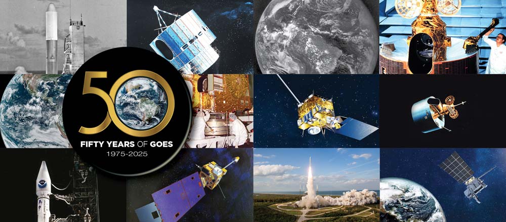
In 2025, NOAA is celebrating 50 years of its heralded GOES satellite program
For five decades, NOAA and NASA have partnered to advance NOAA satellite observations from geostationary orbit
Watch Video GOES 50th Web Page
NOAA Releases Initial Imagery from the GOES-19 Lightning Mapper
The GOES-19 GLM is now continuously observing lightning over the Western Hemisphere.
Feature Story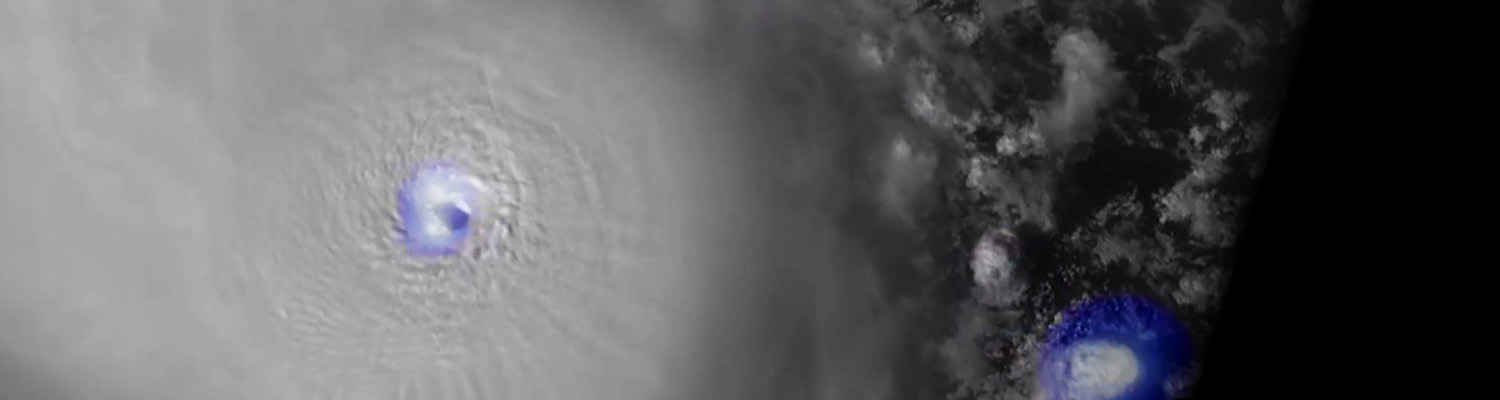
NOAA Debuts First Imagery from GOES-19
On Sept. 18, 2024, NOAA shared the first images of the Western Hemisphere from its GOES-19 satellite.
Feature Story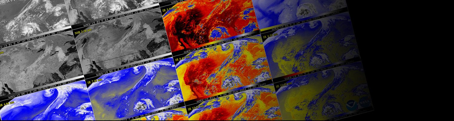
Earth from Orbit
This new video series features significant weather events and environmental hazards, as seen by NOAA satellites.


Images:
NOAA's latest generation of geostationary weather satellites
The Geostationary Operational Environmental Satellite (GOES) – R Series is the nation’s most advanced fleet of geostationary weather satellites. The GOES-R Series significantly improves the detection and observation of environmental phenomena that directly affect public safety, protection of property and our nation’s economic health and prosperity.
The satellites provide advanced imaging with increased spatial resolution and faster coverage for more accurate forecasts, real-time mapping of lightning activity, and improved monitoring of solar activity and space weather.
The GOES-R Series is a four-satellite program (GOES-R/S/T/U) that will extend the availability of the operational GOES satellite system through 2036.
- Improved hurricane track and intensity forecasts
- Increased thunderstorm and tornado warning lead time
- Earlier warning of ground lightning strike hazards
- Better detection of heavy rainfall and flash flooding risks
- Improved transportation safety and aviation route planning
- Improved detection of low cloud/fog
- Improved air quality warnings and alerts
- Better fire detection and intensity estimation
- Improved solar flare warnings for communications and navigation disruptions
- More accurate monitoring of energetic particles responsible for radiation hazards to humans and spacecraft
- Better monitoring of space weather to improve geomagnetic storm forecasting
Remote environmental sensing is only part of the GOES-R Series mission. The satellites also provide unique capabilities to relay data directly to users to meet critical needs
Data Collection System (DCS)
DCS is a satellite relay system used to collect information from Earth-based data collection platforms that transmit in-situ environmental sensor data from more than 20,000 platforms across the hemisphere.
GOES Rebroadcast (GRB)
GOES Rebroadcast provides the primary relay of full resolution, calibrated, near-real-time direct broadcast space relay of Level 1b data from each instrument and Level 2 data from the Geostationary Lightning Mapper (GLM). GRB replaces the GOES VARiable (GVAR) service
High Rate Information Transmission/Emergency Managers Weather Information Network (HRIT/EMWIN)
The Emergency Managers Weather Information Network (EMWIN) is a direct service that provides users with weather forecasts, warnings, graphics and other information directly from the National Weather Service (NWS) in near real-time. The HRIT service is a new high data rate (400 Kpbs) version of the previous LRIT (Low Rate Information Transmission), broadcasting GOES-R Series satellite imagery and selected products to remotely-located user terminals.
Search and Rescue Satellite Aided Tracking (SARSAT)
The SARSAT system detects and locates mariners, aviators and other recreational users in distress. The GOES-R Series continues the legacy function of the SARSAT system on board NOAA’s GOES satellites. This system uses a network of satellites to quickly detect and locate signals from emergency beacons onboard aircraft, vessels and from handheld personal locator beacons. The GOES-R Series SARSAT transponder operates with a lower uplink power than the current system (32 bBm), enabling GOES-R Series satellites to detect weaker beacon signals.
MORE DETAILS
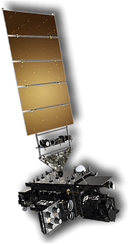
What is GOES-R
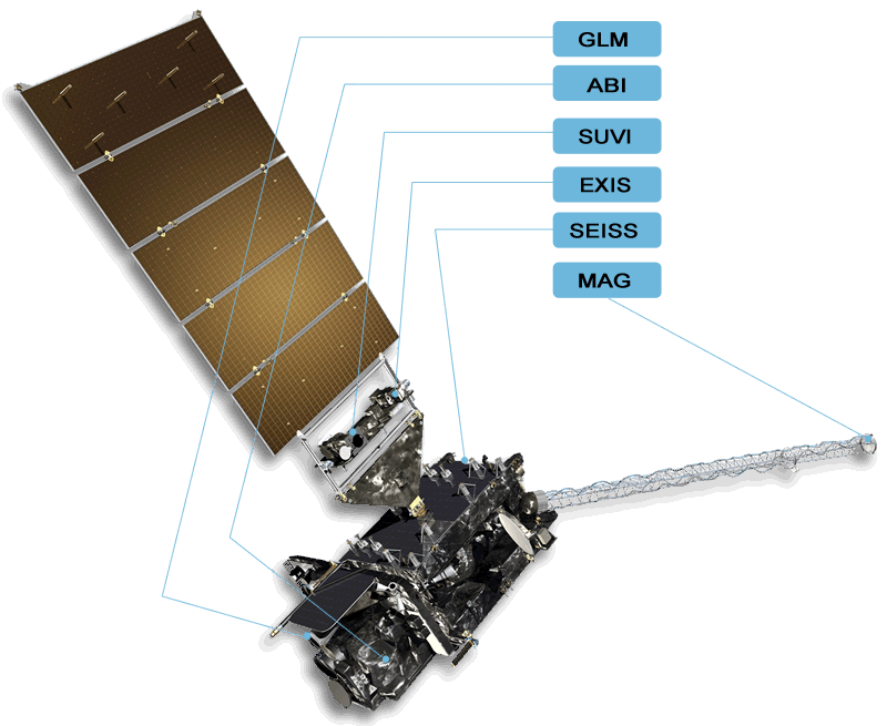
The GOES-R series spacecraft bus is three-axis stabilized and designed for 10 years of on-orbit operation preceded by up to five years of on-orbit storage. The spacecraft carries three classifications of instruments: nadir-pointing, solar-pointing, and in-situ. Visit the Spacecraft page of this site for more information.
Explore the GOES-R Series spacecraft: Use the quick view buttons above to swap the views of the spacecraft, launch the spacecraft 3d model using the button below, watch the video below and use the Spacecraft & Instruments links below.
Spacecraft Specifications
- 6.1 m x 5.6 m x 3.9 m (20.0 ft x 18.4 ft x 12.8 ft)
- 2,857 kg (6,299 lbs) dry mass
- 5,192 kg (11,446 lbs) at launch (fueled)
MORE DETAIL:
Spacecraft & Instruments
GOES-R "Beauty Pass" Video
A fly by in space of GOES-R. Note: there is no audio, therefore no closed captions.
Earth from GOES
Description | More DetailsThe most recent images of Earth's western hemisphere from the GOES constellation.

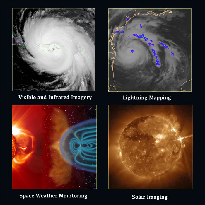
Environmental satellites provide data in several different formats. The most commonly used channels on weather satellites are the visible, infrared, and water vapor.
Visible satellite images, which look like black and white photographs, are derived from the satellite’s signals. Clouds usually appear white, while land and water surfaces appear in shades of gray or black. The visible channel reflects solar radiation. Clouds, the Earth's atmosphere, and the Earth's surface all absorb and reflect incoming solar radiation. Since visible imagery is produced by reflected sunlight (radiation), it is only available during daylight.
In the infrared (IR) channel, the satellite senses energy as heat. The Earth’s surface absorbs about half of the incoming solar energy. Clouds and the atmosphere absorb a much smaller amount. The Earth’s surface, clouds, and the atmosphere then re-emit part of this absorbed solar energy as heat. The infrared channel senses this re-emitted radiation. Infrared imagery is useful for determining cloud features both at day and night.
Water vapor imagery is used to analyze the presence and movement of water vapor moisture in the upper and middle levels of the atmosphere. The wavelength spectrum used to detect water vapor is in the 6.7 to 7.3 micrometer wavelength range. The darker regions in water vapor imagery are areas where very little water vapor exists in the middle and upper troposphere, and the lighter regions are very moist. Water vapor imagery is a very valuable tool for weather analysis and prediction because water vapor imagery shows moisture in the atmosphere, not just cloud patterns. This allows meteorologists to observe large-scale circulation patterns even when clouds are not present.
The National Oceanic and Atmospheric Administration (NOAA) maintains two primary constellations of environmental satellites: geostationary and polar-orbiting. These satellites are part of NOAA's integrated observing system, which includes satellites, radar, surface automated weather stations, weather balloons, sounders, buoys, instrumented aircraft and other sensors, along with the data management infrastructure needed for this system.
Geostationary satellites orbit 35,800 km (22,300 miles) above Earth's equator at speeds equal to Earth's rotation, which means they maintain their positions and provide continuous coverage. Information from geostationary satellites is used for short-term (1 day) weather forecasting and severe storm warning and tracking.
Polar-orbiting satellites make regular orbits around the Earth’s poles from about 833 km (517 miles) above the Earth’s surface. The Earth constantly rotates counterclockwise underneath the path of the satellite, making for a different view with each orbit. Information from polar-orbiting satellites is used for mid-range (3-7 day) forecasts and advanced warnings of severe weather.
GOES satellites continually view the continental United States, Pacific and Atlantic Oceans, Central and South America, and Southern Canada. To fully cover Alaska, Hawaii, the entire continental United States and the Pacific and Atlantic Oceans (for tropical storms), NOAA operates two GOES satellites simultaneously: GOES East and GOES West. GOES East is located at 75.2° W and provides most of the U.S. weather information. GOES West is located at 137.2°W over the Pacific Ocean. In addition to two operational satellites, NOAA also maintains an on-orbit spare.
Since 1975, GOES have provided continuous imagery and data on atmospheric conditions and solar activity (space weather). They have even aided in search and rescue of people in distress. GOES data products have led to more accurate and timely weather forecasts and better understanding of long-term climate conditions. NASA builds and launches the satellites and NOAA operates them.
GOES-R launched on November 19, 2016, and was followed by GOES-S on March 1, 2018. GOES-T launched on March 1, 2022, and GOES-U launched on June 25, 2024.
More Details

GOES-U, the final satellite in the GOES-R Series, launched on June 25, 2024. GOES-U launch aboard a Falcon Heavy rocket from Launch Complex 39A, at NASA’s Kennedy Space Center in Florida. GOES-U reached geostationary orbit on July 7, 2024, and was renamed GOES-19. GOES-19 entered operations as GOES East on April 7, 2025, replacing GOES-16.
GOES-T, the third satellite in the GOES-R Series, launched on March 1, 2022. GOES-T lifted off from Space Launch Complex 41 at Cape Canaveral Space Force Station, Florida, aboard an Atlas V 541 rocket. GOES-T reached geostationary orbit on March 14, 2022, and was renamed GOES-18. GOES-18 replaced GOES-17 as the operational GOES West satellite at 137.0 degrees west longitude on January 4, 2023.
GOES-S launchedon March 1, 2018 and was renamed GOES-17 when it reached geostationary orbit on March 12, 2018. GOES-17 served as GOES West from February 12, 2019 until it was replaced by GOES-18 on January 4, 2023. GOES-17 now resides in on-orbit storage.
The first satellite in the series, GOES-R, launched on November 19, 2016, and became GOES-16 when it reached geostationary orbit. GOES-16 replaced GOES-13 as NOAA’s operational GOES East satellite at 75.2 degrees west longitude on December 18, 2017. GOES-16 is now the on-orbit standby for the operational constellation after being replaced by GOES-19 in the GOES East position on April 7, 2025.
GOES satellites are placed into a geosynchronous orbit that keeps them over a specific location on the earth. By maintaining a position hovering over a fixed point on Earth's surface, GOES are able to constantly monitor atmospheric conditions in a particular portion of the Earth's atmosphere. Note that non-geosynchronous orbits (for example polar orbits) move over an ever-rotating earth underneath them, therefore seeing a constantly changing view, which has advantages for other types of missions.
More Details
GOES-R Launch Sequence and Deployments
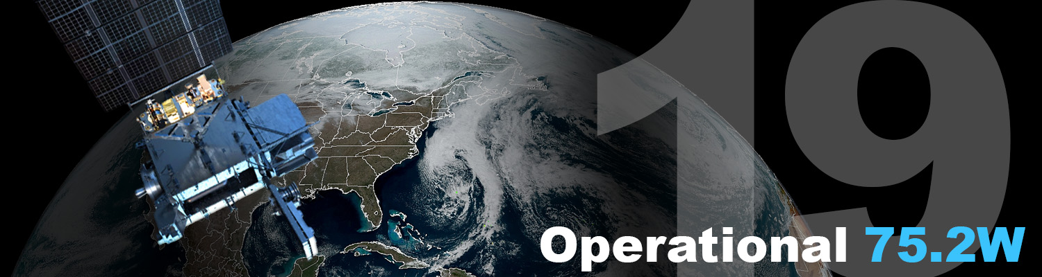
GOES-19
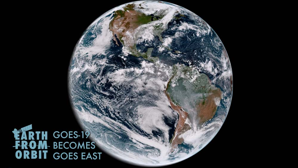
GOES-19 entered operational service as NOAA’s GOES East on April 7, 2025, replacing GOES-16. From its operational location of 75.2 degrees west longitude, GOES-19 is keeping watch over most of North America, as well as South America, the Caribbean, and the Atlantic Ocean to the west coast of Africa.
Learn more about GOES-19’s transition to operations
View GOES-19 (GOES East) imagery at the GOES Image Viewer
GOES-18
GOES-18 replaced GOES-17 as NOAA’s operational GOES West on January 4, 2023. From its operational location of 137.0 degrees west longitude, GOES West is in position to watch over the western contiguous United States, Alaska, Hawaii, Mexico, Central America, and the Pacific Ocean to New Zealand.
Learn more about GOES-18’s transition to operations
View GOES-18 (GOES West) imagery at the GOES Image Viewer
GOES-16
GOES-16 resides at 104.7 degrees west longitude between GOES East and GOES West and serves as the backup for the operational constellation.
Recent News
News Page-
April 7, 2026: Earth From Orbit: One Year of GOES-19 as GOES East
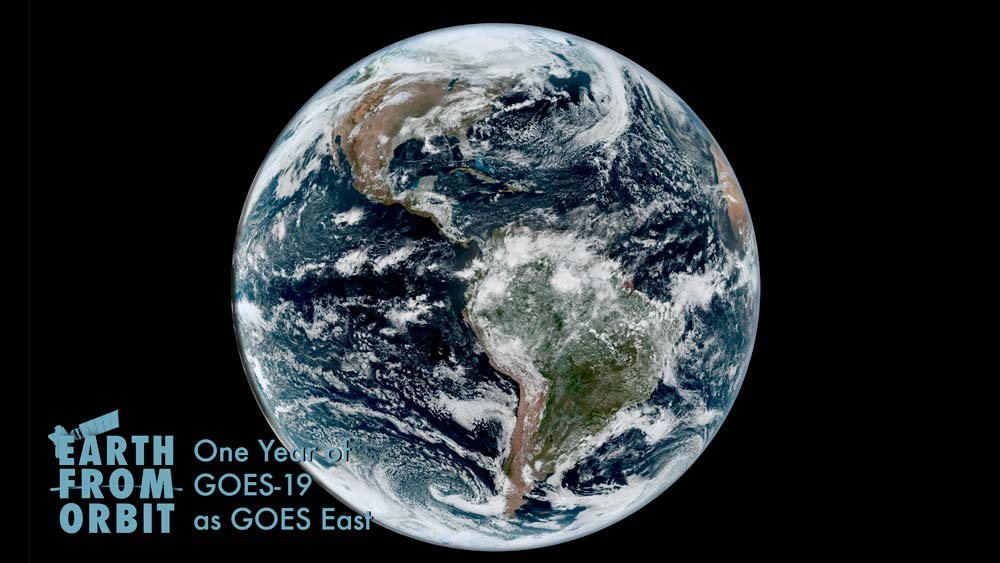
April 7, 2026, marks the one-year anniversary of NOAA’s GOES-19 entering service as GOES East, watching over the Western Hemisphere. In this role, GOES-19 is NOAA’s primary geostationary satellite for detecting and monitoring weather and environmental phenomena that affect the contiguous United States, driving short-term forecasts and warnings. During its first year of operation, GOES-19 provided critical data for a number of high-impact events across the country, from powerful hurricanes and severe storms to wildfires, dust storms, exploding meteors, and solar eruptions.
April
-
January 30, 2026: Earth from Orbit: NOAA Satellites Monitor Massive Winter Storm
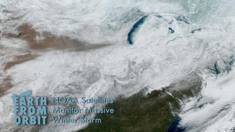
In late January 2026, NOAA’s satellites monitored a massive winter storm that swept across the U.S. and brought heavy snow, ice, and dangerous cold. The winter storm caused hazardous travel conditions, widespread power outages, and major disruptions to air and ground transport. A surge of Arctic air followed the storm, and plunged parts of the central and eastern U.S. into extreme cold. GOES East and GOES West tracked the low-pressure system off the West Coast that produced the massive storm as well as the storm itself. The satellites monitored clouds and atmospheric conditions in near-real time, allowing forecasters to track rapidly-changing weather conditions, determine how fast wind speeds would be at various levels of the atmosphere, identify when the storm was becoming severe, and predict where the storm would move.
January
-
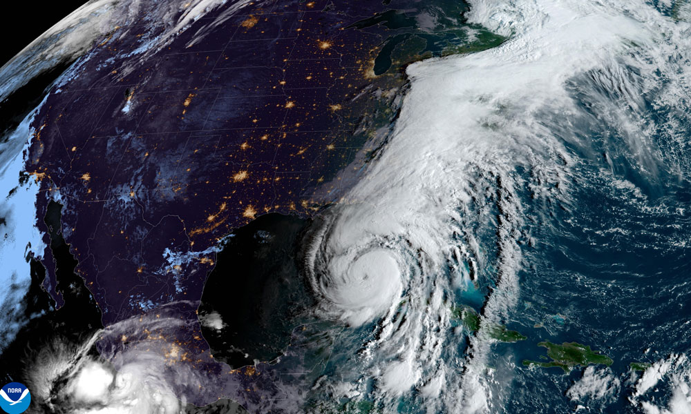
November 25, 2025: 2025 Atlantic Hurricane Season Marked by High-Powered Storms, No U.S. Landfalling Hurricanes
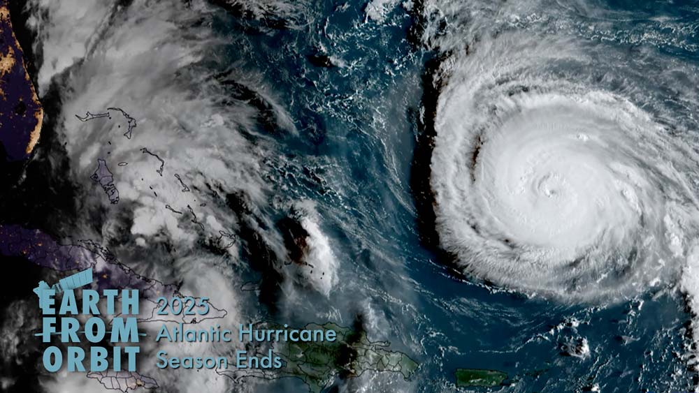
The 2025 Atlantic hurricane season, which officially ends on Nov. 30, showcased near-normal activity, marked by periods of very strong storms. The season fell within the predicted ranges for named storms, hurricanes, and major hurricanes issued by NOAA’s Climate Prediction Center in the August Outlook. The Atlantic basin produced 13 named storms (winds of 39 mph or greater), of which five became hurricanes (winds of 74 mph or greater) and four intensified to major hurricanes with winds reaching 111 mph or greater. No hurricanes made landfall in the continental U.S. for the first time since 2015. NOAA satellites worked together to monitor the Atlantic basin for the development of tropical storm systems and track storms after they formed. GOES-19 data was instrumental for tracking the development, movement, intensity, and lightning activity within tropical storms and hurricanes in near real-time.
-
November 20, 2025: 10 Memorable Images Captured by NOAA’s GOES Satellites

GOES-13 visible imagery of the moon on July 14, 2006 From devastating storms and destructive wildfires to disruptive solar eruptions and captivating atmospheric phenomena, NOAA’s GOES satellites have seen it all. Since 1975, GOES have been our “eyes in the sky,” keeping constant watch over the Western Hemisphere to warn us of severe weather and hazards while providing breathtaking views of Earth. To mark 50 years of GOES in orbit, NOAA is looking back at ten notable events captured by these groundbreaking satellites.
November
-
September 29, 2025: Record-breaking Hurricanes Tracked by NOAA Satellites
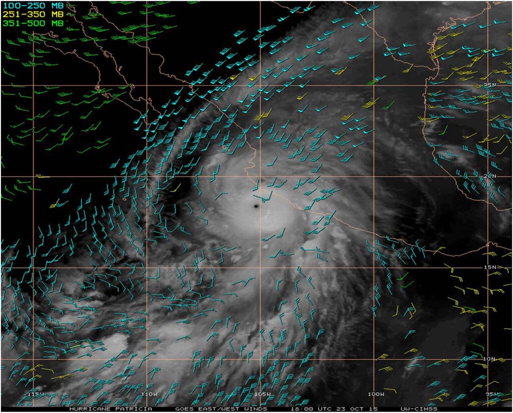
GOES satellite-derived winds for Hurricane Patricia, the most intense hurricane on record in the Western Hemisphere, on Oct. 23, 2015 NOAA satellites have witnessed some pretty extreme events, from massive wildfires and explosive volcanic eruptions to a 515-mile-long lightning flash. Along the way, the satellites have also tracked many record-breaking hurricanes, using a variety of instruments and data products to provide a comprehensive picture of these storms. NOAA satellites provide early warning that a storm is forming, monitor and track the movement of storms, and estimate storm intensity. They also aid emergency response to flooding from landfalling tropical systems. From measuring the most intense to the fastest developing hurricanes, NOAA satellites have provided critical information for forecasters to understand and predict these powerful storms and help communities prepare for their impact.
September
-
August 28, 2025: Earth from Orbit: Hurricane Katrina: Twenty Years Later
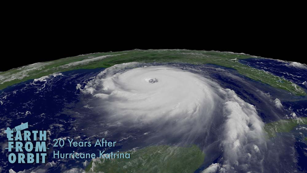
On Aug. 29, 2025, Hurricane Katrina devastated New Orleans and coastal Mississippi. It was one of the deadliest hurricanes on record and remains the costliest hurricane in U.S. history. The 2005 Atlantic hurricane season was record-breaking, with 27 named storms, 14 hurricanes, and three Category 5 storms. That record remained until 2020, when 30 named storms developed. NOAA satellites tracked Katrina as it developed near the Bahamas, made initial landfall on the southeastern coast of Florida, rapidly intensified into a Category 5 hurricane, and finally left its mark on New Orleans and coastal Mississippi. Today, NOAA satellites are more advanced than ever. NOAA satellite advancements have resulted in more timely and accurate forecasts and warnings, more precise landfall predictions, and a better understanding of hurricane dynamics. While satellites can’t stop hurricanes, they give us knowledge to prepare, protect and save lives. As we remember the impact of Hurricane Katrina, NOAA satellites remain our sentinels in the sky, providing critical data.
-
August 22, 2025: Earth from Orbit: Category 5 Erin is the First Atlantic Hurricane of 2025
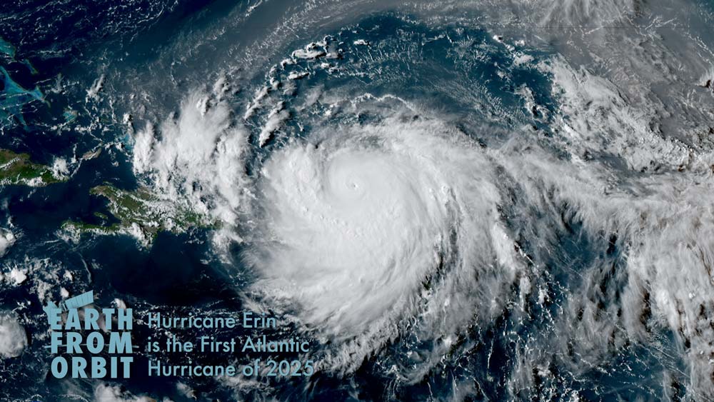
After a relatively quiet start to the Atlantic hurricane season, Erin became the first hurricane of the year in the Atlantic basin on Aug. 15 and rapidly intensified into a major Category 5 storm the following day. This intensification is one of the fastest on record. NOAA satellites provided vital information for forecasting and monitoring Erin. Rapid, high-resolution imagery from GOES-19 gave forecasters a detailed look at Erin’s structure, including its pinhole eye. Rapidly updating imagery also helps forecasters better monitor cloud features and more confidently estimate the center of a tropical storm or hurricane. GOES-19 infrared imagery helped forecasters to track the location and persistence of rain bands near the Caribbean islands, aiding predictions of rainfall and potential flash flooding. GOES-19 also monitored lightning activity within Hurricane Erin as it rapidly intensified.
August
-
June 26, 2025: Lightning Safety Awareness Week: Detecting Lightning From Space
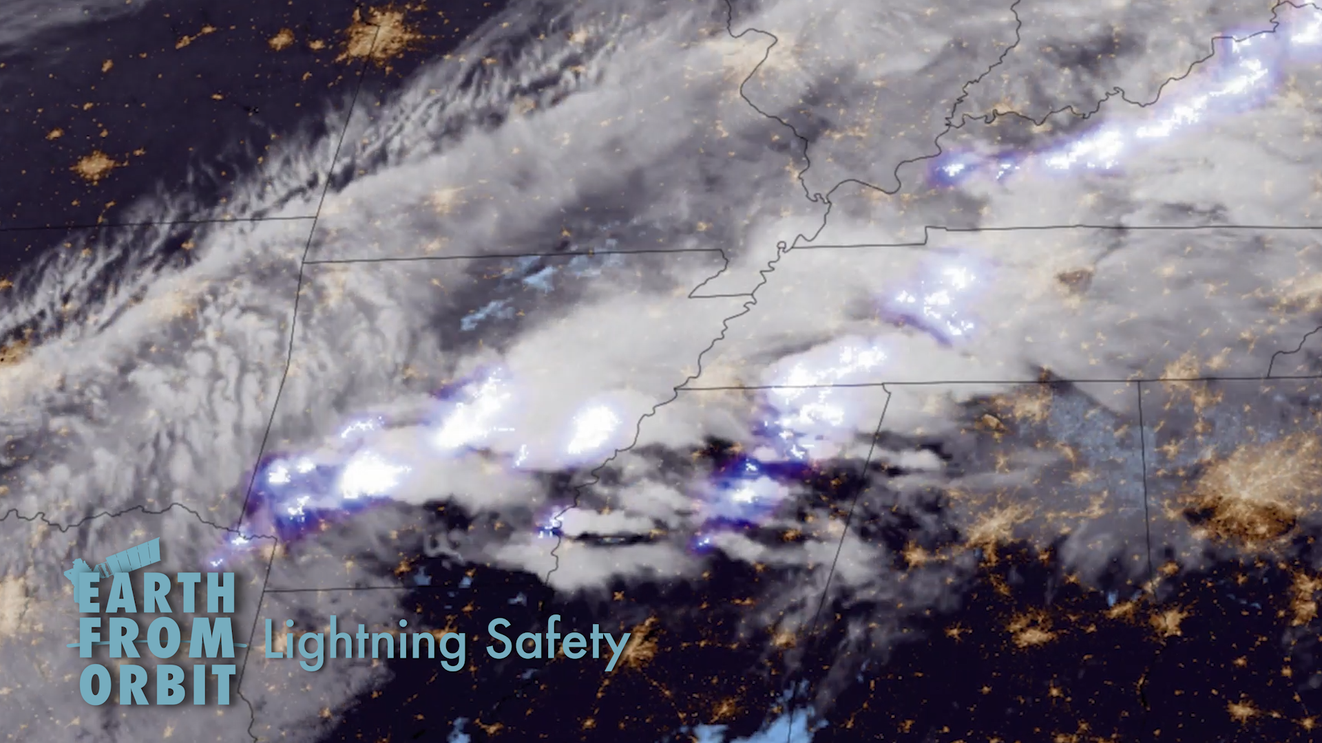
Lightning is a dangerous hazard that poses a significant threat to life and property. For National Lightning Safety Awareness Week (June 22-28, 2025), NOAA is highlighting the capabilities of its Geostationary Lightning Mapper (GLM) instrument onboard the GOES-18 (GOES West) and GOES-19 (GOES East) satellites. GLM detects and maps lightning activity within storms. Its data can show forecasters areas where the risk of lightning strikes presents a public safety hazard. GOES data can also help predict the occurrence of lightning in the future. An AI model called LightningCast predicts where lightning is most likely to occur up to 60 minutes in advance. Forecasters use LightningCast to help keep people who are working and participating in outdoor events safe.
-
June 25, 2025: NOAA’s GOES-U Satellite: One Year Later
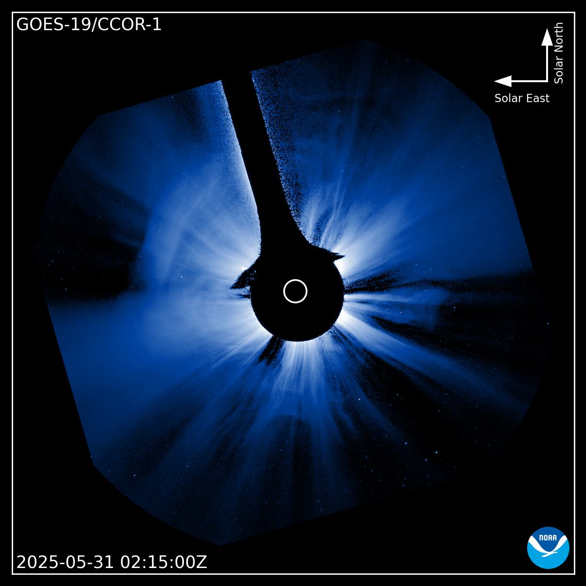
CCOR-1 imagery of a CME that triggered a severe geomagnetic storm warning for Earth on May 31, 2025. CCOR-1 observed the CME 21 minutes before other coronagraph imagery was available. On June 25, 2024, GOES-U, the final satellite in NOAA’s GOES-R Series, launched from NASA’s Kennedy Space Center in Florida. Once GOES-U reached geostationary orbit on July 7, the satellite was renamed GOES-19. As NOAA marks the first anniversary of sending GOES-U into space, we check in with the newest satellite in NOAA’s fleet. On April 7, 2025, GOES-19 replaced GOES-16 as NOAA’s operational GOES East satellite. In its new role, GOES-19 serves as NOAA's primary geostationary satellite for monitoring much of the Western Hemisphere. The satellite tracks hurricanes and tropical storms in the Atlantic Ocean basin and monitors severe weather, atmospheric rivers, wildfires, volcanic eruptions and other environmental events affecting the contiguous U.S. GOES-19 has already proved vital for short-term forecasts and warnings of severe weather as well as detecting and monitoring hazards such as wildfires and smoke. The satellite’s new CCOR-1 instrument is helping NOAA’s Space Weather Predication Center sharpen its geomagnetic storm forecasts and provide earlier warnings, buying critical time for the operators of power grids, satellites, aviation systems, and communication networks.
-
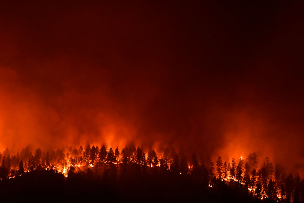
June 5, 2025: Earth From Orbit: NOAA Satellites Monitor Canadian Wildfires and Smoke
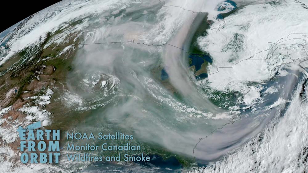
NOAA satellites have been closely monitoring heat signatures and thick plumes of smoke (some stretching thousands of miles) from wildfires burning across Canada. Numerous fires flared up last week causing widespread evacuations in three provinces. Manitoba alone had about 17,000 residents evacuated. Smoke from these wildfires has been wafting southward, affecting air quality across much of the northern, central, and eastern U.S. GOES East and GOES West tracked the smoke as it spread across North America in near real-time. GOES West also detected the formation of pyrocumulonimbus clouds over fires burning in Alberta, Canada. These thunderstorms can form above wildfires due to intense heat and rising smoke.
June
-
May 27, 2025: 50 Years of Monitoring the Stormy Seas: Hurricane Tracking with NOAA’s GOES Satellites
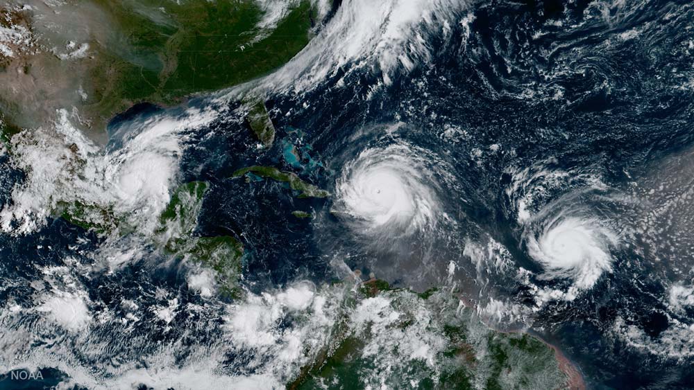
Image of Three hurricanes in the Atlantic on Sept. 18, 2017: Irma, Jose and Katia. For 50 years, NOAA’s Geostationary Operational Environmental Satellites (GOES) have kept a constant vigil over the Western Hemisphere. These sentinels in the sky provide essential information to forecasters, first responders, emergency managers, local officials and the public about severe weather and hazards. Each new generation of GOES has advanced our understanding of hurricanes and led to significant forecast and warning improvements, protecting lives and property through increasingly accurate, timely and reliable data. As hurricane season begins, NOAA looks back at how far hurricane observations from geostationary orbit have come since 1975.
-
May 23, 2025: NOAA Satellites Track Deadly Severe Weather Across the Nation
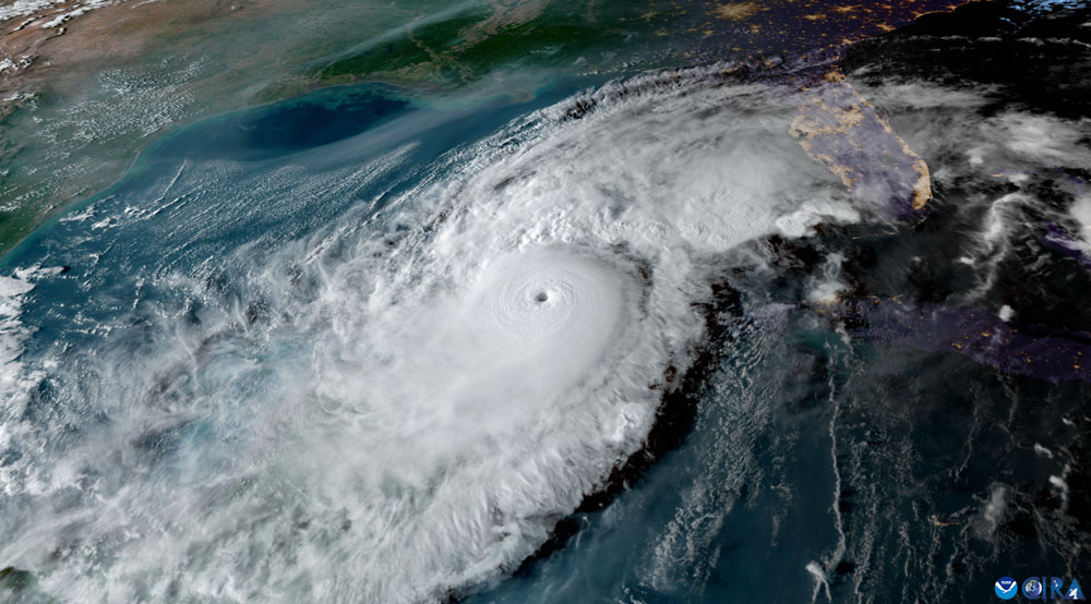
Image of Hurricane Milton from NOAA's GOES-16 satellite on Oct. 8, 2024. NOAA satellites monitored potent and complex spring weather pattern responsible for nearly a week-long stretch of severe weather, including two destructive tornado outbreaks across the central U.S. from May 15-16 and May 18-20, 2025. The National Weather Service used NOAA satellite data for advanced warnings, real-time updates, and on-site support to emergency managers during the storm. In some parts of Kentucky, tornado warnings had lead times of up to 40 minutes. GOES-19 tracked the system in near real-time as it raced across the U.S. GOES-19 imagery revealed where the storms were most intense and allowed forecasters to monitor rapidly changing conditions. The satellite’s lightning mapper detected rapid increases in lightning activity, indicating intensifying storms. Forecasters also use GOES data in new AI models that predict the likelihood that a developing thunderstorm will produce severe weather or hazardous lightning an hour or more in advance.
-
May 22, 2025: NOAA Satellites Have You Covered This Hurricane Season
Image of Hurricane Milton from NOAA's GOES-16 satellite on Oct. 8, 2024. The 2025 Atlantic Hurricane Season officially begins June 1, and NOAA’s eyes in the sky are ready for whatever the season may bring. NOAA satellites are critical for monitoring the development, intensification and track of tropical storms and hurricanes each hurricane season. Imagery from these satellites help forecasters at the National Hurricane Center determine when a tropical depression or storm has formed and when the structure of the system may allow for rapid intensification. These data are crucial for warning the public of storm surge, wind and rainfall hazards associated with landfalling tropical storms and hurricanes.
-
May 20, 2025: NOAA unveils powerful convergence of AI and science with revolutionary Next-Generation Fire System technology
GOES-18 imagery of California's Park Fire and smoke on July 26, 2024 Less than a year after being evaluated in NOAA’s Fire Weather Testbed, the automated satellite fire detection capability of the experimental Next Generation Fire System (NGFS) has been embraced by the firefighting community and is being increasingly integrated into operations across the country. The first of two key features of the revolutionary system are the Advanced Baseline Imager, the primary instrument on NOAA’s two GOES geostationary satellites orbiting 22,000 miles above the equator. The second is a set of NGFS algorithms that continuously comb through enormous volumes of data generated by the imager and automatically identifies heat anomalies or hot spots, even through clouds and smoke.
-
May 20, 2025: Environmental Intelligence: Sensing Danger from Orbit
GOES-16 image of Hurricane Helene on September 26, 2024 NOAA satellites provide data that Americans use daily. Maintaining this “environmental intelligence” is critical to U.S. Armed Forces operations. NOAA satellite data – whether used for monitoring erosion around deep-water ports, forecasting wind and air quality near airstrips, or sustaining reliable global positioning accuracy – is vital for defending national security. NOAA’s information feeds weather prediction models used every day in the United States and around the world. Interagency collaborations are a force multiplier for observations of both Earth and space, as shown through agreements between NOAA, NASA, the Department of Defense, and other federal partners. Frameworks like these improve forecasts by sharing data and technology with operators.
-
May 7, 2025: Satellites and Fire: AMS SatMOC Short Courses
The American Meteorological Society (AMS) Committee on Satellite Meteorology, Oceanography, and Climatology (SatMOC) will offer a virtual short course with NOAA collaborators titled “Satellites and Fire" during June 2025. This short course will consist of four virtual training sessions of four hours each. The training sessions are scheduled for 9:00 AM to 1:00 PM ET on June 17, 18, 24, and 25, 2025. This series of four training sessions will demonstrate the use of environmental satellite data to monitor the stages of wildland fires and the vegetative conditions associated with those stages. All sessions will include hands-on exercises for selecting and applying environmental satellite data products used to monitor wildland fire conditions.
May
-
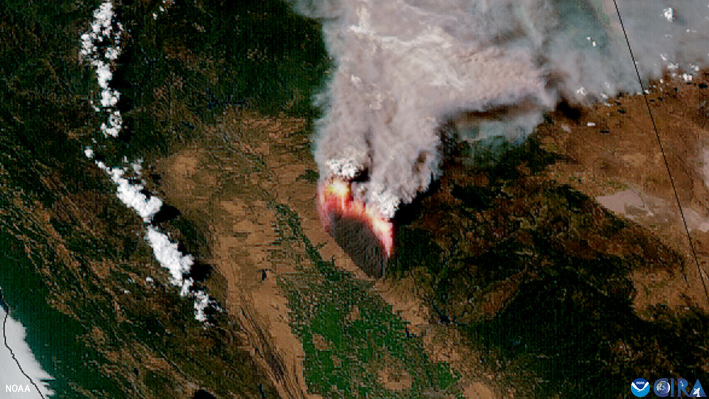
May 2, 2025: Earth from Orbit: NOAA Satellites Track Large New Jersey Wildfire
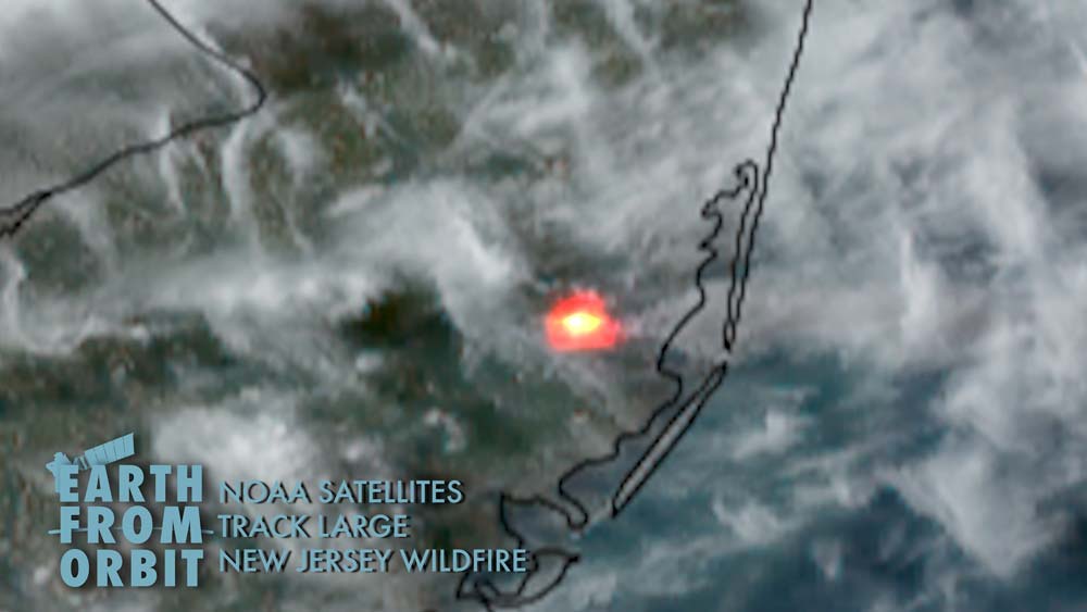
NOAA satellites monitored a large fire that erupted in Ocean County, New Jersey, on April 22, 2025, and quickly grew into one of the worst fires in the state’s history. GOES-19 monitored the movement and intensity of the fire in near real-time as it rapidly spread. NOAA also used GOES-19 imagery in its new wildfire tool, the Next Generation Fire System (NGFS). NGFS uses artificial intelligence to scan satellite imagery and quickly identify new fires down to the neighborhood level. In an era of increasingly severe wildfires, NOAA satellites provide indispensable tools for protecting communities and managing natural disasters.
May
-
April 22, 2025: Earth From Orbit: Happy Earth Day from NOAA Satellites
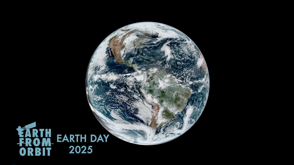
NOAA satellites have been monitoring Earth’s weather and environment since 1970, which also happened to be the year the first official Earth Day took place! Building upon early pioneering efforts by NASA and others, today’s advanced satellites provide critical information that feeds forecast models and warns us of severe weather and environmental hazards. For NOAA, every day is Earth Day. Take a look back at our world since last April 22.
-
April 7, 2025: NOAA’s GOES-19 satellite now operational, providing critical new data to forecasters
On April 7, 2025, GOES-19 entered operational service as GOES East. The fourth and final satellite in the GOES-R Series launched on June 25, 2024. In its new role, GOES-19 watches over much of the Western Hemisphere. It will track hurricanes and tropical storms in the Atlantic basin, as well as monitor severe weather, atmospheric rivers, wildfires, volcanic eruptions and other environmental events. The satellite also carries a suite of space weather instruments, including NOAA’s first compact coronagraph instrument (CCOR-1). CCOR-1 images the outer layer of the sun’s atmosphere to detect and characterize coronal mass ejections and warn of impending geomagnetic storms. With GOES-19 joining the fleet, NOAA’s geostationary satellite constellation is set to carry on its longstanding mission and deliver life-saving data into the 2030s. Watch the Earth from Orbit video.
April
-
March 12, 2025: How NOAA Satellites Help Us Stay Ahead of Severe Weather Season
GOES-16 visible and infrared imagery of a squall line of severe thunderstorms producing damaging winds marching through the Southeast U.S. on March 4, 2025. Each year, the arrival of spring brings the increasing probability for severe weather to the United States. From their orbits, NOAA satellites play a vital role in detecting and tracking severe weather by providing forecasters with critical data to predict and monitor life-threatening conditions. Geostationary Operational Environmental Satellites (GOES) enable continuous coverage of severe weather threats in the U.S., while the polar-orbiting Joint Polar Satellite System (JPSS) satellites deliver higher resolution global observations for long-term forecasting. Together, these advanced satellites help safeguard lives and property.
-
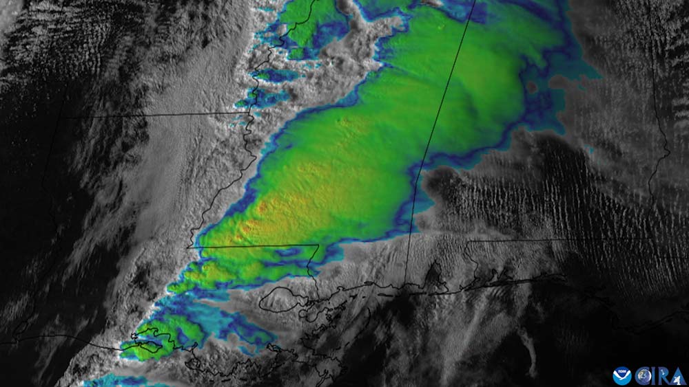
March 7, 2025: Earth from Orbit: NOAA Satellites Monitor Hazardous Early Spring Storm
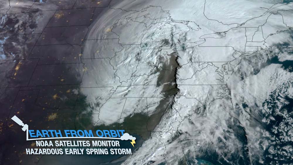
NOAA satellites monitored a large storm system as it pushed across the Central U.S. in early March 2025. The system prompted widespread weather alerts for everything from blizzard warnings and wind advisories to tornado watches and heightened wildfire risks across much of the country. NOAA’s GOES satellites tracked the system in near real-time, providing forecasters and first responders with critical information about the storm. The Advanced Baseline Imager (ABI) helped track rapidly changing weather conditions, analyze the structure of the storm, and pinpoint areas where the storm was the most intense. The ABI also identified several wildfire ignitions across the Southern Plains, alerting the National Weather Service to the threat. The Geostationary Lightning Mapper (GLM) measured lightning activity and helped provide early warning that the storm was intensifying. Dynamic storm systems like this demonstrate the strength and unpredictability of spring weather. NOAA satellites remain vital for forecasting and monitoring these storms as well as their impacts, helping to protect lives, property, and economic vitality.
March
-
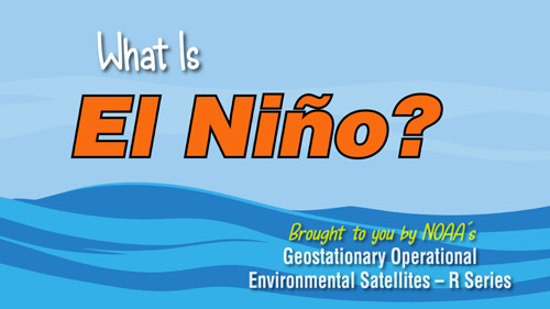
February 14, 2025: What is El Niño?
Have you ever heard a news headline mentioning that unusual or extreme weather is expected due to El Niño? But what exactly is El Niño? And what does it have to do with our weather? A new video from NOAA SciJinks explains this phenomenon and how meteorologists can use information from GOES-R satellites to help predict if an El Niño pattern is forming.
-
February 6, 2025: Earth from Orbit: NOAA Satellites Track Powerful Atmospheric Rivers Impacting the West Coast
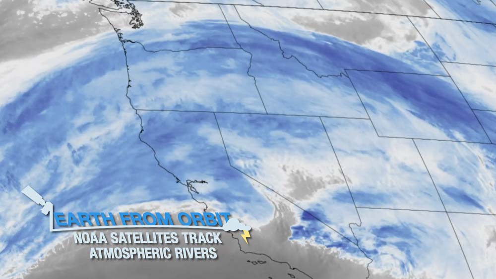
Since Jan. 31, 2025, NOAA satellites have been closely monitoring a series of strong atmospheric rivers bringing heavy rain and mountain snow from central California to the Pacific Northwest, the Sierras, southern Cascades, and northern Rocky mountains. GOES-18 (GOES West) provides detailed information about moisture in the atmosphere and allows forecasters to track atmospheric rivers as they happen. The satellite provides critical data about the movement of clouds and water vapor patterns that help to forecast heavy rain and flash flooding from atmospheric rivers. As atmospheric rivers continue to impact the western U.S., NOAA satellites will closely monitor these events and provide critical information to forecasters and local communities.
February
-
January 21, 2025: GOES-R/GeoXO Newsletter, October – December 2024
The GEO team gathered in October 2024 to celebrate building and launching all four satellites in the GOES-R Series. The GOES-R/GeoXO quarterly newsletter for October – December 2024 is now available. As GOES-19 prepares to enter operational service, the team is recognized for the tremendous amount of hard work and dedication they have put into GOES-R since 1999. From the very start of the program, the GOES-R team has been recognized as setting the standard for satellite and ground system development as well as inter-agency collaboration. The GOES-R system will continue to serve our nation providing observations of severe weather and environmental conditions into the 2030s, while the focus of our team now turns to GeoXO development. We completed the Mission Definition Review in December, are working on evolving the ground system for GeoXO, and are preparing to enter the preliminary design phase. Congressional support of GeoXO has us on track for planned launches. It is an exciting time as we make NOAA’s next-generation geostationary satellite system a reality, bringing new and improved capabilities to meet our users’ needs and address emerging environmental challenges.
-
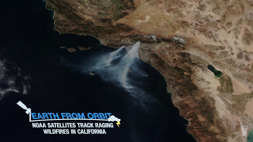
January 21, 2025: Earth from Orbit: NOAA Satellites Track Raging Wildfires in California
NOAA satellites are closely monitoring wildfires burning in the Los Angeles metropolitan area. The first blazes erupted on Jan. 7, 2025, and quickly exploded in size and intensity, prompting widespread evacuation orders. The destructive wildfires have destroyed thousands of structures and claimed the lives of at least 25 people according to reporting by local authorities. GOES-18 (GOES West) monitored the fires in near real-time, measured the intensity, tracked the spread and movement of smoke.
-
January 14, 2025: NOAA Celebrates 50 Years of GOES Satellites
In 2025, NOAA is celebrating 50 years of its heralded Geostationary Operational Environmental Satellite program, known as GOES. For five decades, NOAA and NASA have partnered to advance NOAA satellite observations from geostationary orbit. GOES are our sentinels in the sky: keeping constant watch for severe weather and environmental hazards on Earth and dangerous space weather. As NOAA celebrates the long legacy of the GOES, we continue to rely on these satellites for short-term forecasts of hazardous weather, detection and monitoring of environmental phenomena like wildfires, smoke, volcanic ash, dust storms and fog, and warnings of approaching space weather that can disrupt communication and navigation systems, disrupt power grids, damage satellites in space and expose astronauts to harmful radiation.
January
MORE NEWS