GOES-R Series News | 2017
-
December 27, 2017: GOES-16’s Momentous Year in Forecasting
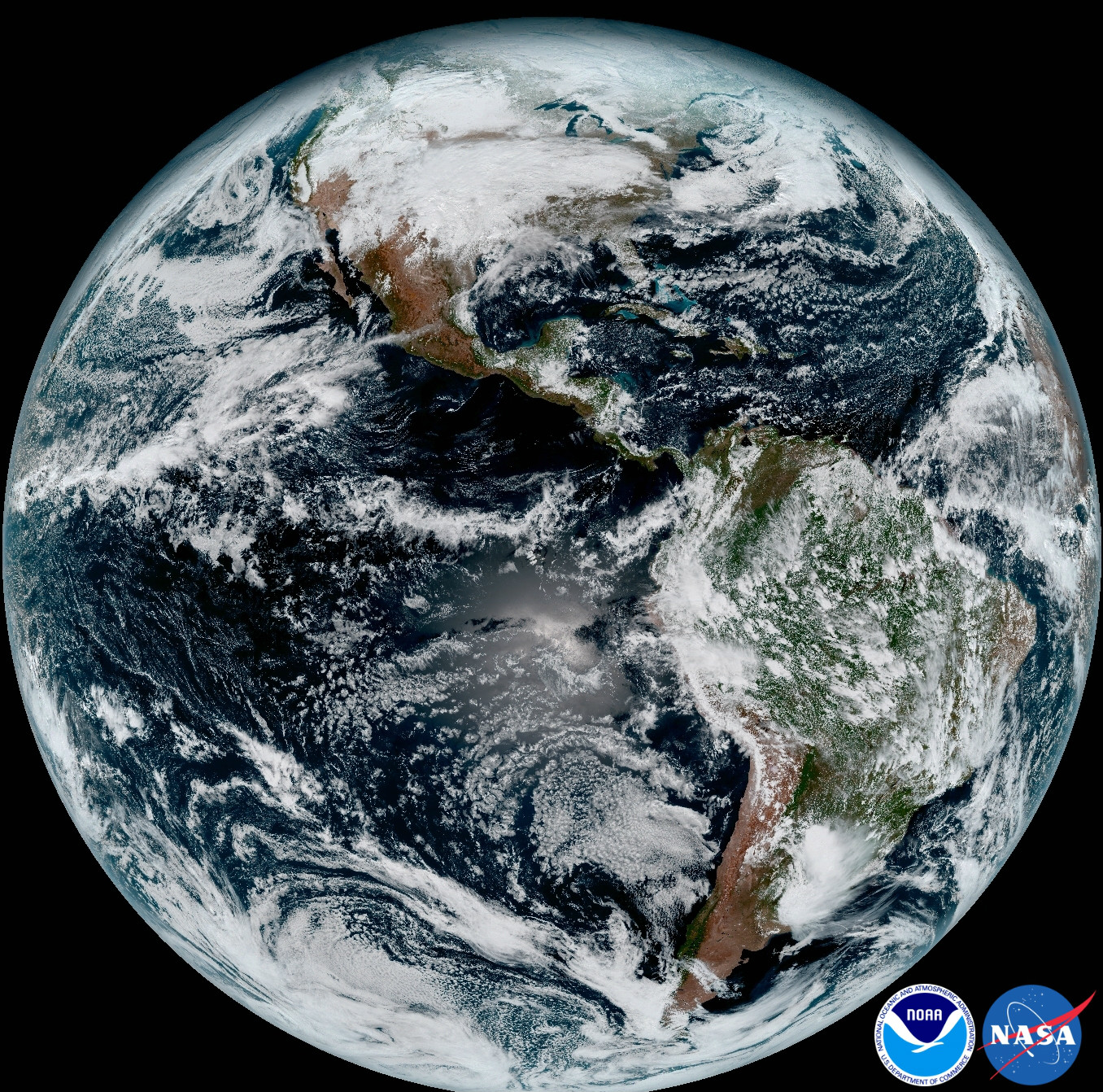
![GOES-16 geocolor image of Hurricane Maria over Puerto Rico as it made landfall on September 20, 2017]()
GOES-16 geocolor image of Hurricane Maria over Puerto Rico as it made landfall on September 20, 2017 This year, forecasters had a revolutionary new forecasting tool at their disposal – NOAA’s GOES-16 satellite. Brand new instrumentation, additional spectral information, improved resolution, and faster scanning ability, as well as new product development allow GOES-16 to provide information on meteorological features like never before. Thanks to GOES-16, forecasters and emergency managers are better equipped with more accurate weather predictions and faster warnings. Take a look back at GOES-16’s momentous year.
-
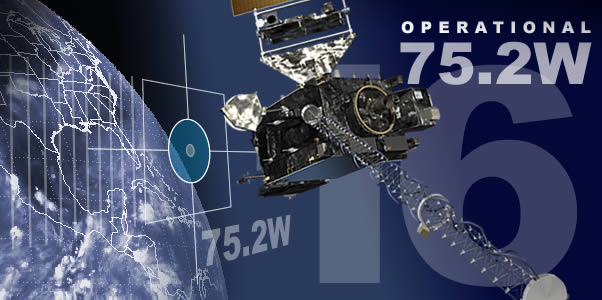
December 18, 2017: GOES-16 is now Operational as NOAA’s GOES East!
![First geocolor image from GOES-16 at 75.2 degrees west, taken December 12, 2017]()
GOES-16 full disk geocolor imagery taken from the operational GOES East position on December 18, 2017 NOAA’s most advanced geostationary environmental satellite, GOES-16, has taken its place in the operational constellation, and is now operational as NOAA’s GOES East. From its position at 75.2 degrees west longitude, 22,240 miles above the equator, GOES-16 is now keeping an eye on North and South America and the Atlantic Ocean all the way to the west coast of Africa. GOES-16 is already proving to be a game changer in weather forecasting and hazard assessment, providing detailed views of hurricanes, severe thunderstorms, wildfires, fog and more in near real-time. Learn more in this press release | View GOES-16 Operational Imagery
-
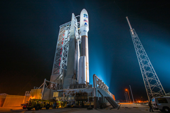
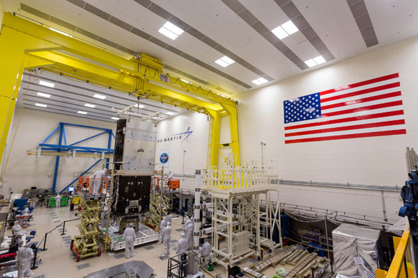
December 7, 2017: GOES-S Arrives at Kennedy Space Center to Prepare for Launch
![GOES-S arriving at Kennedy Space Center in Florida aboard a U.S. Air Force C-5M]()
GOES-S arriving at Kennedy Space Center in Florida aboard a U.S. Air Force C-5M GOES-S is getting closer to joining GOES-16 in orbit! On December 4, 2017, NOAA’s GOES-S satellite was shipped from Lockheed Martin Space Systems in Littleton, Colorado, to NASA’s Kennedy Space Center in Florida aboard a U.S. Air Force C-5M Super Galaxy cargo transport. The satellite has been unpacked and is now undergoing additional testing and preparation for launch. GOES-S is scheduled to launch on March 1, 2018, aboard an Atlas V 541 rocket from Cape Canaveral Air Force Station in Florida. After a successful launch and reaching geostationary orbit, GOES-S will be renamed GOES-17. Read the NASA press release | View the NOAA photo essay | See additional photos of the journey
-
December 5, 2017: 2018 AMS Short Course: GOES-R Series: Products And User Applications
The AMS Short Course, GOES-R Series: Products And User Applications will be held on January 7, 2018, preceding the 98th American Meteorological Society Annual Meeting in Austin, Texas. This course is designed to communicate to users the new capabilities made possible by NOAA’s next-generation GOES-R Series Advanced Baseline Imager (ABI), Geostationary Lightning Mapper (GLM), and derived products for improved environmental intelligence, forecasts and warnings. Short-course participants will have the opportunity to receive hands-on experience with GOES-16 data, showcasing the many applications to help improve forecasts and warnings of high impact weather and environmental phenomena. The primary goal of this course is to familiarize users with GOES-R Series capabilities, and how it can improve their services to customers, saving lives and property. Learn more about the short course │ Register for the short course
December


-
November 30, 2017: GOES-16 Begins Drift to Operational Location
![Last image captured by GOES-16 ABI before the instrument went offline to prepare for drift operations.]()
Last image captured by GOES-16 ABI before the instrument went offline to prepare for drift operations. On November 30, 2017, GOES-16 began drifting from its checkout location at 89.3 degrees west longitude to its operational location at 75.2 degrees west. During the drift, the satellite’s main instruments are in safe or diagnostic modes and not transmitting data. GOES-16 is scheduled to be in its operational location and transmitting data by December 20, 2017. GOES-16 will replace GOES-13 as NOAA’s operational GOES East satellite, keeping watch over most of North America, as well as Central and South America, the Caribbean and the Atlantic Ocean to the coast of Africa. GOES-13 will be placed in storage. Read the detailed transition plan.
-
November 19, 2017: Happy Launch-iversary GOES-16!
![GOES-16 liftoff]()
GOES-16 liftoff It was one year ago, November 19, 2016, that NOAA’s GOES-16 satellite was launched into space. Though not yet operational, GOES-16 is already proving to be a game-changer for weather forecasting and hazard assessment. From hurricanes to thunderstorms, flooding, fog, fires, blizzards and more, GOES-16 has kept watch from 22,000 miles above the Earth. Take a look back at the past year and see what’s ahead in this feature.
November

-
October 30, 2017: GOES-R Series Program Quarterly Newsletter: July – September 2017
![GOES-S Teacher Workshop]()
GOES-S Teacher Workshop The GOES-R Quarterly Newsletter for the time period July – September 2017 is now available. The 2017 hurricane season has given GOES-16 the opportunity to showcase its advanced capabilities. Forecasters are marveling at the unparalleled imagery from the satellite. As work continues to transition GOES-16 to operations in December, our team is focusing on preparing GOES-S for launch in the spring. View the 3Q 2017 newsletter.
-
October 23, 2017: GOES-16 Drift and Transition to Operational Location
![GOES-16 Drift and Transition]()
GOES-16 Drift and Transition to Operational Location GOES-16 is planned to begin drifting to the GOES East operational location of 75.2 degrees west longitude on November 30, 2017. The drift is scheduled to complete on December 11, 2017, and nominal operations will resume by December 20, 2017. During the drift period, five instruments (ABI, GLM, SUVI, SEISS, and EXIS) will be placed in safe or diagnostic modes and will not be capturing or distributing data. MAG is the only instrument that will continue to operate with nominal data distribution during the transition. GOES Rebroadcast (GRB), Data Collection System (DCS), High Rate Information Transmission (HRIT)/ Emergency Managers Weather Information Network (EMWIN), and the Search and Rescue Satellite-Aided Tracking (SARSAT) system will be disabled during drift. This is due to X-band radio frequency downlink interference. All drift and transition operations will be led by the NESDIS Office of Satellite and Product Operations with GOES-R Program operational support. Final scheduling of drift operations may change based on operational needs and will be a NOAA-level decision. Read the full transition plan.
October
-
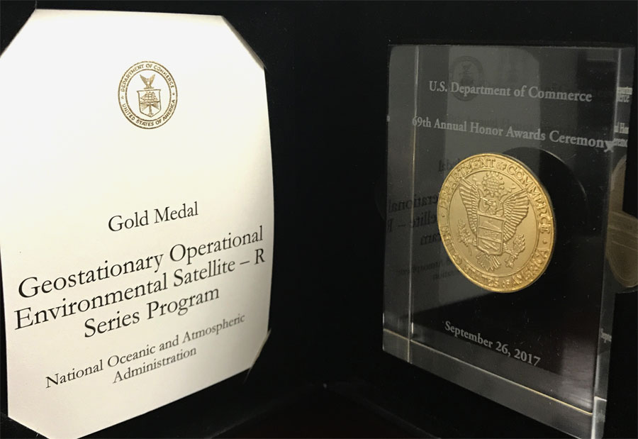
September 26, 2017: GOES-R Series Program Presented with Department of Commerce Gold Award
![GOES-R Series Program Presented with Department of Commerce Gold Award]()
Department of Commerce Gold Medal On September 26, 2017, Acting GOES-R Series Program Director Mike Stringer accepted the Department of Commerce Gold Medal on behalf of the GOES-R team at the 69th Annual Honor Awards Ceremony. The program was cited “for their tireless dedication and contributions by completing the GOES-R satellite, which launched on November 19, 2016. The GOES-R Team completed a highly complex, integrated operational mission-system development; readied the satellite and system for launch and operations, including active engagement with a network of operational users; and delivered the GOES-16 satellite to orbit within cost and meeting all technical requirements. Their excellence sets the foundation for the next 20+ years of weather forecasting for our Nation.” The Gold Medal, the highest honorary award given by the Department of Commerce, is granted by the Secretary for distinguished performance, characterized by extraordinary, notable, or prestigious contributions that impact the mission of the Department and/or one operating unit and that reflect favorably on the Department.
-
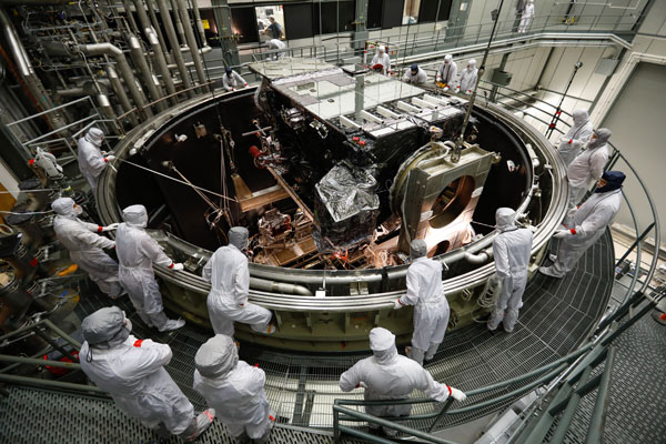
September 23, 2017: GOES-T Mate Complete
![The GOES-T system module and core propulsion module]()
GOES-T mate operation The “mating” of the GOES-T system module and core propulsion module occurred on September 22, 2017, at Lockheed Martin in Littleton, Colorado. During the mate, the system module, or “brain,” and propulsion module, or the “body,” of the spacecraft were merged together to form the integrated GOES-T spacecraft. Learn more about the GOES-T Mate feature story.
-
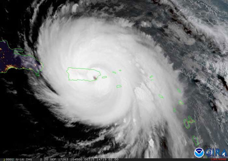
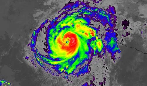
September 21, 2017: GOES-16 Provides Critical Data on Hurricane Maria When Radar Goes out
![Image caption:: GOES-16 geocolor image of Hurricane Maria as it made landfall in Puerto Rico]()
GOES-16 geocolor image of Hurricane Maria as it made landfall in Puerto Rico. Although not yet operational, data from NOAA’s GOES-16 satellite proved vital in forecasting operations for Hurricane Maria as it neared Puerto Rico on September 20, 2017. Radar in San Juan went out at 5:50 a.m. EDT, just before Maria made landfall on the island. With this critical technology disabled and a major hurricane approaching, forecasters were able to utilize data from NOAA’s latest geostationary satellite, GOES-16, to track the storm in real-time. Learn more about GOES-16’s tracking of Maria in this feature story.
-
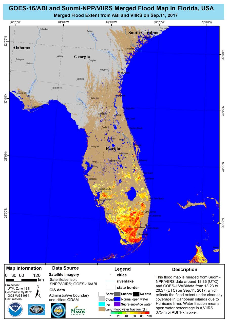
September 15, 2017: GOES-16 Monitoring Catastrophic Flooding from Hurricanes Harvey and Irma
![Image caption:: Map highlighting the impact of Hurricane Irma in Florida as of Sept. 11, 2017]()
Map highlighting the impact of Hurricane Irma in Florida as of Sept. 11, 2017 When a catastrophic storm hits, the resulting floods can be deadly and cost billions of dollars in economic losses. In the U.S., floods are responsible for more loss of life and property than any other severe weather event. GOES-16, along with the NOAA-NASA Suomi NPP satellite are monitoring the flooding from Hurricanes Harvey and Irma. Data from the two satellites are merged to create detailed and comprehensive flood zone maps, which help FEMA and first responders determine where to focus their efforts. View the maps and learn more about the effort.
September

-
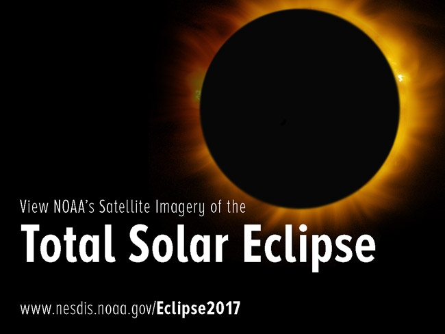
August 18, 2017: View NOAA's Satellite Imagery of the Total Solar Eclipse
![Image of Image of solar eclipse]()
On August 21, 2017, the first total solar eclipse to move across the United States in 99 years will occur. GOES-16 will capture the eclipse with the Advanced Baseline Imager (ABI) which will have a clear view of the moon’s shadow as it travels diagonally across the path of totality of the Continental United States from the Pacific Northwest through South Carolina. Visit the NOAA Satellites 2017 Total Solar Eclipse web page for more information. Check the GOES-16 Data and Imagery page on this site on August 21 for imagery of the eclipse.
-
August 9, 2017: GOES-16’s Lightning Mapper Demonstrates Lightning Behavior
Map highlighting the impact of Hurricane Irma in Florida as of Sept. 11, 2017 Lightning occurs more frequently over land than ocean, and hurricanes generally don't produce much lightning. But lightning is sometimes present in the eyewall of a hurricane – the most intense part of such storms. In addition, lightning is more likely to occur in a hurricane’s rainbands when a storm moves over land. When lightning is seen in the eyewall, it's an indication of possible changes in storm intensity. Learn more about how GOES-16 is observing lightning behavior in this story from NOAA Satellites.
-
August 3, 2017: NOAA’s GOES-S and GOES-T Satellites Coming Together
![GOES-T EXIS (left) and SUVI (right) are integrated]()
The GOES-T EXIS (left) and SUVI (right) are integrated with the solar-pointing platform of the spacecraft. Progress continues on the development of the GOES-S and GOES-T spacecraft that will follow GOES-16 into geostationary orbit. The GOES-S satellite is fully integrated and undergoing functional testing to prepare it for launch in spring 2018. In parallel with GOES-S testing, assembly of GOES-T is moving forward. Learn more about GOES-S and GOES-T progress in this feature story.
August
-
July 21, 2017: 2017 NOAA Satellite Conference
The 2017 NOAA Satellite Conference was held July 17-20, 2017, at The City College of New York. NSC 2017 brought together users and providers of polar-orbiting and geostationary satellite data, data products, and applications from the public, private, and academic sectors. The theme for the conference was “A New Era for NOAA Environmental Satellites.” The conference included sessions on the GOES-R Series as well as GOES-16 introductory and advanced training
-
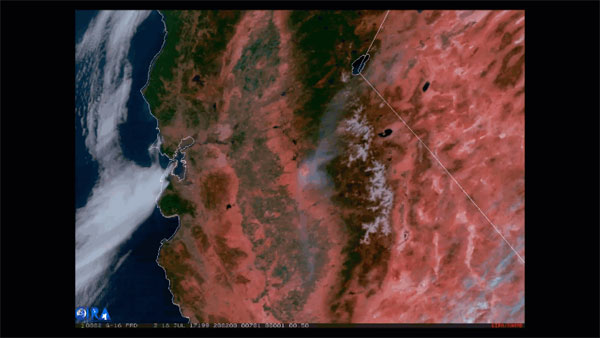
July 19, 2017: GOES-16 Provides Imagery of Fire Hot Spots Like Never Before
![GOES-16 dust enhancement product highlighting a large plume of dust from the desert southwest being dragged eastward, across northwestern Texas and east Oklahoma.]()
Wind pushes smoke from Wind pushes smoke from central California's Detwiler Fire to the northeast in this GOES-16 imagery from July 18, 2017, that combines Fire Temperature and Geocolor imagery. GOES-16 captured imagery of central California’s Detwiler Fire on July 18, 2017, using the Fire Temperature RGB (red-green-blue) product, which utilizes three Advanced Baseline Imager shortwave and near-infrared bands that detect hot spots. Learn more about this product and view an animation of the fire in this feature story.
-
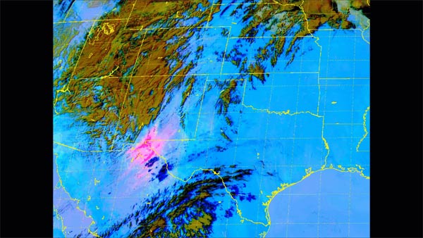
July 11, 2017: It’s a Dusty World: NOAA Satellites Help Us Keep Track of It
![GOES-16 dust enhancement product highlighting a large plume of dust from the desert southwest being dragged eastward, across northwestern Texas and east Oklahoma.]()
This imagery from GOES-16 shows a large plume of dust in the desert southwest on March 24, 2017 It's dusty out there. Beyond the research indicating the frequency of dust storms is on the rise around the world, scientists estimate that, on average, about 20 teragrams of dust are suspended in the atmosphere at any given time. Fortunately GOES-16 is on the job to help us spot dust storms. This feature story explains the advanced capabilities for dust detection from GOES-16.
-
July 7, 2017: GOES-R Series Program Quarterly Newsletter: April ‒ June 2017
![GOES-16 saw its first hurricane]()
GOES-16 saw its first hurricane on June 26, 2017 The GOES-R Quarterly Newsletter for the time period April ‒ June 2017 is now available. With the handover of GOES-16 to NOAA’s Office of Satellite and Product Operations and its operational location assigned, we move closer to GOES-16 becoming an operational satellite as GOES East in November. Scientists and engineers are hard at work to validate the entire system. View the 2Q 2017 newsletter, highlighting GOES-16 post-launch activities and preparations for launching GOES-S next spring.
-
July 5, 2017: GLM Data Now Available Via GOES Rebroadcast
![GLM lightning density]()
GLM lightning density over the Eastern U.S. on July 5, 2017 The Geostationary Lightning Mapper (GLM) has completed a product validation review and lightning data is now being distributed to users through the GOES Rebroadcast (GRB) system. All GOES-16 instruments are now transmitting data via GRB! The GOES-16 data are currently in beta status which means the data is minimally validated and not optimized for operational use. It is intended to help users gain familiarity with data formats and parameters. Additional updates and validation will take place before GOES-16 becomes operational in November. Access real-time GOES-16 lightning data from NASA SPoRT.
July
-
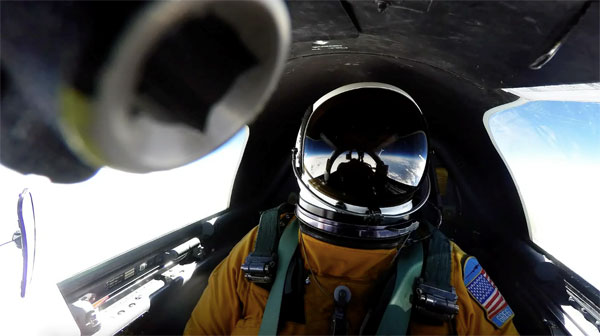
June 27, 2017: Hunting for Lightning
![65,000 feet above Earth]()
65,000 feet above Earth, the NASA ER-2 pilot calmly waits to adjust course and intercept lightning-producing storms The GOES-16 Field Campaign, a two-month effort to calibrate and validate the Earth-viewing instruments on NOAA’s GOES-16 satellite, completed mission operations in May. The second phase of the field campaign focused on validating the satellite’s lightning mapper. This feature story highlights a day in the life of the field campaign, as the team hunts for lightning. By clearly measuring a lone, well-defined lighting flash with the plane’s instruments, the satellite’s Geostationary Lightning Mapper (GLM), and various ground sensors, scientists can perform an important “one-to-one” comparison to hone in on the GLM’s detection threshold, or sensitivity, for light. Interested in more information about the field campaign? Check out this feature story on the purpose of the mission and learn more about the validation of the satellite’s imager in this recap of phase one of the field campaign.
-
June 23, 2017: GOES-16 Handover
![Mike and Vanessa]()
GOES-R Series Program Acting System Program Director Mike Stringer hands over the “key” to GOES-16 to NOAA Office of Satellite and Product Operations Director Vanessa Griffin On June 20, the GOES-16 Handover Readiness Review (HRR) was successfully completed. The HRR certified readiness to transition operational responsibility of GOES-16 from the GOES-R Program to the NOAA Office of Satellite and Product and Operations (OSPO) operations team. NESDIS Assistant Administrator Dr. Steven Volz gave final approval for the transition on June 23 and GOES-16 satellite operations were officially handed over to OSPO!
-
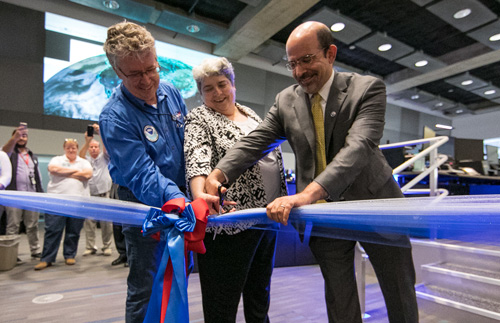
June 23, 2017: NSOF Satellite Operations Control Center
![Ribbon cutting]()
Ribbon cutting ceremony for the new Satellite Operations Control Center at NSOF. Satellite operations at the NOAA Satellite Operations Facility (NSOF) in Suitland, Maryland, were relocated from the Launch Control Room to the newly renovated Satellite Operations Control Center on June 9. A ribbon cutting ceremony was held on June 23 at NSOF to officially open the new control center.
-
June 21, 2017: GOES-16 Sees the Summer Solstice Arrive
The summer solstice -- the official start of astronomical summer in the Northern Hemisphere -- occurred at 12:24 am (EDT) on June 21, 2017. GOES-16 captured the solstice with its Advanced Baseline Imager. This feature story provides information about the solstice and GOES-16 visible imagery of the event.
-
June 1, 2017: GOES-16 Magnetometer Data Available Via GOES Rebroadcast
![GOES-16 Magnetometer (MAG)]()
First GOES-16 MAG Data On June 1, preliminary data from the GOES-16 Magnetometer will be made available via GOES Rebroadcast (GRB) for users in the weather community with GRB antennas to evaluate. Please note that we are still in the process of calibrating and validating the data, which is not meeting performance expectations at this time. Providing the beta data now to the user community, including the primary user the National Weather Service’s Space Weather Prediction Center, allows for collaborative evaluation of the data while efforts are underway to improve performance.
-
May 25, 2017: GOES-16 Will Go East
![GOES East]()
GOES East Observational Coverage On May 25, 2017, NOAA announced GOES-16’s operational location at the 2017 Atlantic Hurricane Season Outlook press conference in College Park, Maryland. The GOES East position was chosen primarily because it offers full coverage of the continental United States and provides optimal viewing of the states and cities in the plains, mid-west and east most impacted by severe weather events including Atlantic Hurricanes, thunderstorms and tornadoes, major winter storms, and flooding. GOES-16 will move to its operational position at 75 degrees west longitude in November 2017. Until then, the satellite will remain in its current check-out location to allow engineers and scientists to complete checkout and validation of the GOES-16 instruments and science data products. Read the press release for more information.
-
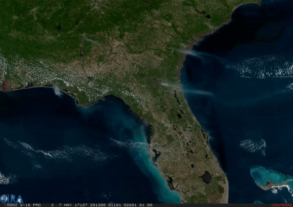
May 11, 2017: Satellites Play Vital Role in Spotting, Monitoring Fires
![GOES East]()
GOES-16 geocolor imagery captured on May 7, 2017, shows smoke plumes from several fires burning in the southeastern United States. Fires, whether naturally occurring or man-made, have substantial impacts on both the landscape and air quality. Fortunately, satellites like GOES-16 can detect and monitor fires large and small, and provide data on a range of factors, including location, duration, size, temperature and intensity. How do NOAA satellites detect and monitor fires from space? Learn more about the Monitoring Fires feature story.
-
May 11, 2017: GOES-16 Post-Launch Assessment Review
The GOES-16 Post-Launch Assessment Review (PLAR) was successfully completed on May 9. The PLAR is an evaluation of the readiness of the spacecraft systems to proceed with routine operations. An independent review team evaluated the flight and data operations readiness, satellite performance and the readiness to transfer responsibility from the development organization to the operations organization. The passage of this milestone keeps the program on track for the Handover Readiness Review in June.
June

May
-
April 21, 2017: 2017 NOAA Satellite Conference
![Phase One complete]()
2017 NOAA Satellite Conference The 2017 NOAA Satellite Conference (NSC) will be held July 17-20 at City College of New York. NSC 2017 will bring together users and providers of polar-orbiting and geostationary satellite data, data products, and applications from the public, private, and academic sectors. Representatives from more than 40 countries will participate in this event. The theme for the conference is “A New Era for NOAA Environmental Satellites.”
-
April 11, 2017: GOES-R Series Program Quarterly Newsletter: January‒March 2017
![Phase One complete]()
GOES-S TVAC The GOES-R Quarterly Newsletter for the time period January‒March 2017 is now available. The momentum continues with the release of the first data and imagery from GOES-16 and preparing the satellite to become operational in November. Scientists and engineers are hard at work to validate the entire system. View the 1Q 2017 newsletter, which highlights the first imagery from the satellite, post-launch activities, and preparations for launching GOES-S next year.
-
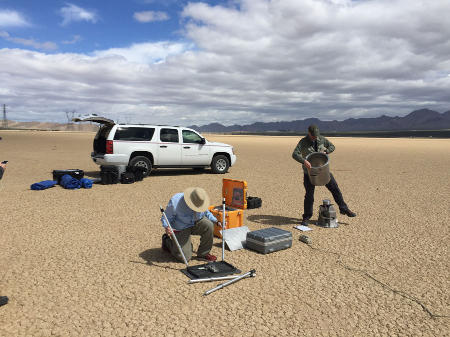
April 11, 2017: Phase One of GOES-16 Field Campaign Complete
![Phase One complete]()
Ground validation support Flying out of Palmdale, California, NASA’s ER-2 high-altitude plane and its suite of highly specialized instruments took to the air over the Sonoran Desert in Mexico and the Mojave Desert in Ivanpah, California on March 23 and 28 to validate GOES-16’s ABI— the satellite’s primary instrument. Data from the ER-2 instruments were verified by an array of ground sensors and compared to ABI scans of the corresponding area. Learn more about the GOES-16 Field Campaign feature story.
April
-
March 31, 2017: GOES-R Ground System: Less Discussed, but Equally Important
When the topic du jour turns to satellite meteorology and its benefits, the spacecraft usually get all the attention. This stands to reason, but there is no denying that satellites are only half of the highly specialized technical apparatus that collects remotely sensed data and makes it available to scientists. The other, less talked-about half of this system is commonly referred to as the “ground system.” Learn more about the GOES-R Ground System feature story.
-
March 30, 2017: Preparing GOES-16 for Operations
It may seem that once a satellite is successfully launched, the work is done. But there’s a lot more that goes into making sure it’s ready to provide data for your local weather forecast. The GOES-16 satellite is currently undergoing post-launch testing. What does that mean? Launching a satellite is like opening a new restaurant. Post-launch testing is like a soft opening with a limited audience, which allows for trouble-shooting and preparing for the grand opening. During post-launch testing, there are periodic, planned data outages that are necessary to perform specific verification and validation functions. These outages are generally brief and part of normal post-launch testing, and they are part of the reason it’s important not to depend on GOES-16 data for operational needs during the testing period. Learn more about post-launch testing in this feature story.
-
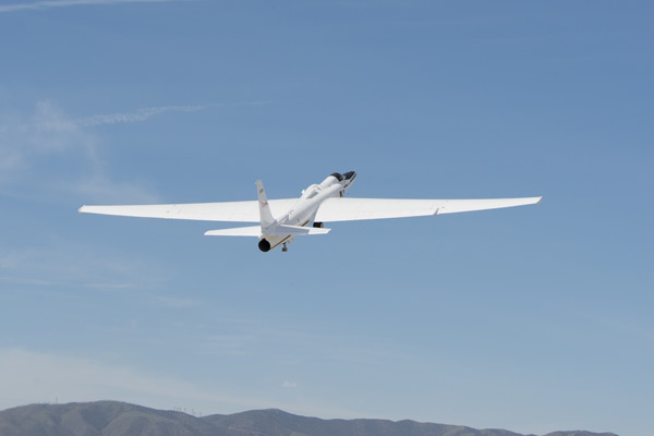
March 22, 2017: GOES-16 Field Campaign
![Campaign Test Flight]()
GOES-16 Field Campaign Test Flight The GOES-16 post-launch field campaign is now underway. During this three month campaign, a team of instrument scientists, meteorologists, GOES-16 engineers, and specialized pilots will use an outfit of high-altitude planes, ground-based sensors, unmanned aircraft systems (or drones), the International Space Station, and the NOAA/NASA Suomi NPP polar-orbiting satellite to collect measurements across the United States to support validation of the GOES-16 Advanced Baseline Imager and Geostationary Lightning Mapper instruments. Learn more about the field campaign in this feature story.
-
March 17, 2017: GOES-16 First Results Workshop
In recognition of the newly available GOES-16 cloud and moisture imagery, and providing an opportunity to reach out and expand user readiness, the GOES-R Series Program will offer a special one-day GOES-16 First Results workshop on April 27, 2017. The workshop will be held in conjunction with the 8th NOAA Testbeds and Proving Grounds Annual Workshop at the National Weather Service Training Center in Kansas City, Missouri.
-
March 9, 2017: A Note to the Weather Community about Using GOES-16 Data
NOAA's National Environmental Satellite, Data, and Information Service appreciates the enthusiasm in the weather community and support for our newest on-orbit satellite, GOES-16, which will enhance the weather forecasts that save lives and protect property nationwide.
At this time, data from GOES-16 are considered preliminary and are undergoing validation testing. NOAA is therefore requesting that any organizations that redistribute GOES-16 data -- before it is declared operational -- include the following disclaimer with the data:
"NOAA's GOES-16 satellite has not been declared operational and its data are preliminary and undergoing testing."
Users receiving these data through any dissemination means (including, but not limited to, PDA and GOES Rebroadcast) assume all risk related to their use of GOES-16 data and NOAA disclaims any and all warranties, whether express or implied, including (without limitation) any implied warranties of merchantability or fitness for a particular purpose.
It is expected that GOES 16 data will be declared operational, approximately 6-12 months after launch, which occurred in November 2016.
-
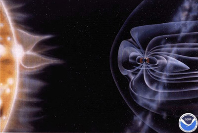
March 8, 2017: GOES-16: Our Newest and Best Defense against the Threats of Space Weather
![Space weather Artist Rendition]()
Artist Rendition of Space Weather Space weather may sound like the stuff of science fiction, but it’s quite real and taken very seriously. Earth-bound radioactive waves and particles from a solar storm can disrupt communications, navigation, and power grids; cause damage to spacecraft; and even put astronauts and airline passengers at risk of exposure to space radiation.
Technologists have been aware of the threats posed by space weather for years and previous GOES satellites have carried space-weather instruments to monitor and predict potentially harmful space weather. However, none of these earlier instruments were as advanced or capable of providing as much information about the conditions of the sun and near-space environment as the space weather sensors aboard GOES-16. Learn why GOES-16 is our newest and best defense against the threats of space weather.
-
March 6, 2017: Flashy First Images Arrive from GOES-16 Lightning Mapper
![First GOES-16 Lightning Data]()
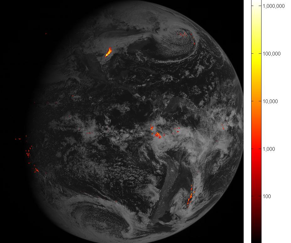
First GOES-16 Lightning Data Detecting and predicting lightning just got a lot easier. The first images from the Geostationary Lightning Mapper (GLM), a new instrument onboard NOAA’s GOES-16 satellite, are giving forecasters richer information about lightning that will help them alert the public to dangerous weather.
This image shows 1.8 million lightning images accumulated by GLM over one hour, displayed over full disk imagery from the Advanced Baseline Imager. Brighter colors indicate more lightning energy was recorded; color bar units are the calculated kilowatt-hours of total optical emissions from lightning. The brightest storm system is located over the Gulf Coast of Texas.
March
-
February 27, 2017: First Solar Images from GOES-16
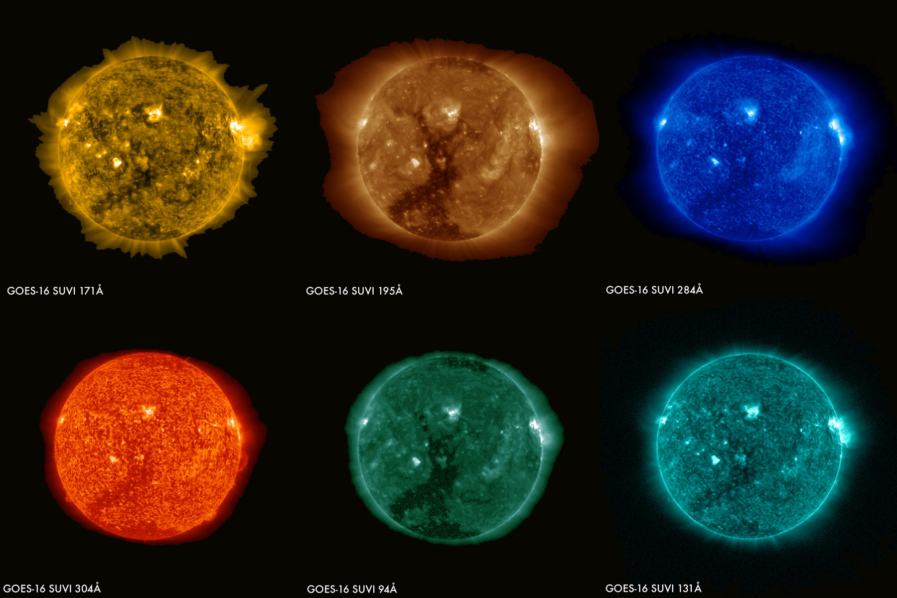
![First Solar Images from SUVI]()
First Solar Images from GOES-16 SUVI The first images from the Solar Ultraviolet Imager (SUVI) instrument aboard the GOES-16 satellite captured a large coronal hole on the sun on January 29, 2017. The sun’s 11-year activity cycle is currently approaching solar minimum and during this time powerful solar flares become scarce and coronal holes become the primary space weather threat. Once operational, SUVI will capture full-disk solar images around-the-clock and will be able to see more of the environment around the sun than earlier NOAA geostationary satellites.
-
February 10, 2017: New Data from NOAA GOES-16’s Space Environment In-Situ Suite (SEISS) Instrument
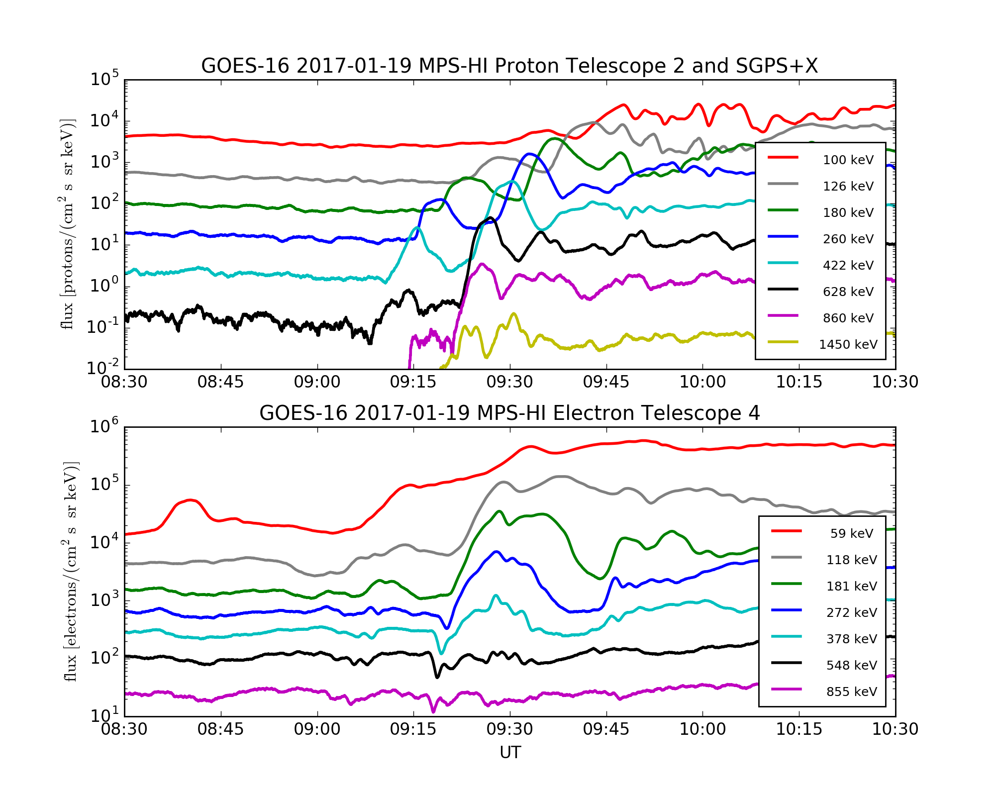
![First Data from GOES-16 SEISS Instrument]()
First Data from GOES-16 SEISS Instrument The new Space Environment In‐Situ Suite (SEISS) instrument onboard NOAA’s GOES-16 is working and successfully sending data back to Earth! This plot shows how fluxes of charged particles increased over a few minutes around the satellite on January 19, 2017. These particles are often associated with brilliant displays of aurora borealis at northern latitudes and australis at southern latitudes; however, they can pose a radiation hazard to astronauts and other satellites, and threaten radio communications. Information from SEISS will help NOAA's Space Weather Prediction Center provide early warning of these high flux events, so astronauts, satellite operators and others can take action to protect lives and equipment. This SEISS data shows injections of protons and electrons observed by the Magnetospheric Particle Sensors MPS-HI and Solar and Galactic Proton Sensor (SGPS) on January 19, 2017. MPS-HI and SGPS are two of the individual sensor units on SEISS. The fluxes shown are from the MPS-HI telescopes that look radially outward from the Earth, and from the lowest-energy channel observed by the eastward-looking SGPS.
SEISS is composed of five energetic particle sensor units. The SEISS sensors have been collecting data continuously since January 8, 2017, with an amplitude, energy and time resolution that is greater than earlier generations of NOAA’s geostationary satellites.
-
February 3, 2017: First Data Released from GOES-16 EXIS Instrument Shows Solar Flare
![EXIS First Data on January 21, 2017]()
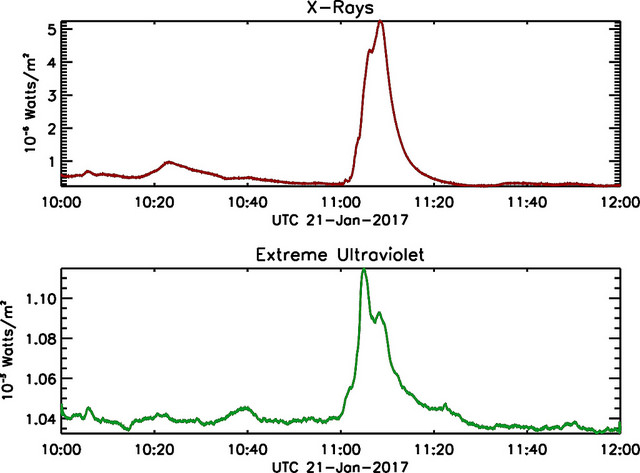
EXIS First Data on January 21, 2017 Solar flares are huge eruptions of energy on the sun and often produce clouds of plasma traveling more than a million miles an hour. When these clouds reach Earth they can cause radio communications blackouts, disruptions to electric power grids, errors in GPS navigation, and hazards to satellites and astronauts. The Extreme Ultraviolet and X-Ray Irradiance Sensors (EXIS) instrument on NOAA’s GOES-16, built by the University of Colorado’s Laboratory for Atmospheric and Space Physics in Boulder, Colorado, measures solar flares at several wavelengths and improves upon current capabilities by capturing larger flares, measuring the location of the flares on the sun, and measuring flares in more wavelengths. The GOES-16 EXIS will provide forecasters at the NOAA’s Space Weather Prediction Center with early indications of impending space weather storms so they can issue alerts, watches and warnings.
The figure shows an example of EXIS observations at two different wavelengths of a flare that peaked at 11:05 UTC [6:05 a.m. EST] on January 21, 2017. This is a relatively small flare, yet the brightness of the sun in soft (lower energy) X-rays increased by a factor of 16. EXIS will give NOAA and space weather forecasters the first indication that a flare is occurring on the sun, as well as the strength of the flare, how long it lasts, the location of the flare on the sun, and the potential for impacts here at Earth.
February
-
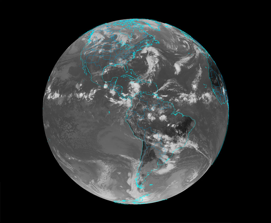
January 23, 2017: NOAA’s GOES-16 Satellite Sends First Images to Earth
![GOES-R, has sent its first, high-resolution images]()
ABI Full Disk Color Composite from Jan. 15, 2017 NOAA’s GOES-16 satellite, formerly known as GOES-R, has sent its first, high-resolution images, and now people around the world can see what this revolutionary satellite sees. The first images usher in a new era of Earth and space weather observation for the U.S. View images and animations from GOES-16’s new Advanced Baseline Imager (ABI) instrument, showing the complete full disk of the Western Hemisphere and the continental United States in all 16 channels of the ABI instrument. Learn more about GOES-16 and its first imagery via the NOAA Satellites press release.
-
January 19, 2017: GOES-R Series Program Quarterly Newsletter: October-December 2016
![GOES-R Quarterly Newsletter for the time period October-December 2016]()
GOES-R Launch The GOES-R Quarterly Newsletter for the time period October-December 2016 is now available. The future of weather forecasting is here! After years of research, development and integration, GOES-R (now GOES-16) successfully launched on November 19, 2016, made it to geostationary orbit, and is sending back data! View the 4Q 2016 newsletter, which highlights the road to launch, launch and post-launch activities.
-
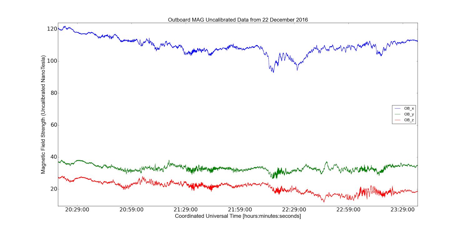
January 5, 2017: Scientists Receive Preliminary Data from GOES-16's Magnetometer
![GOES-16 Magnetometer (MAG)]()
First GOES-16 MAG Data On December 22, 2016, the GOES-16 Magnetometer (MAG) became the first instrument on the satellite to begin transmitting data! Earth’s geomagnetic field acts as a shield, protecting us from hazardous incoming solar radiation. Geomagnetic storms, caused by eruptions on the surface of the sun, can interfere with communications and navigation systems, cause damage to satellites, cause health risks to astronauts, and threaten power utilities. When a solar flare occurs, GOES-16 will tell space weather forecasters where it happened on the sun and how strong it was. Using that information, forecasters can determine if the explosion of energy is coming toward Earth or not. The GOES-16 MAG samples five times faster than previous GOES magnetometers, which increases the range of space weather phenomena that can be measured. This plot shows preliminary data from the outboard Magnetometer instrument on board the GOES-16 satellite observed December 22, 2016.