GOES-R Series News | 2020
-
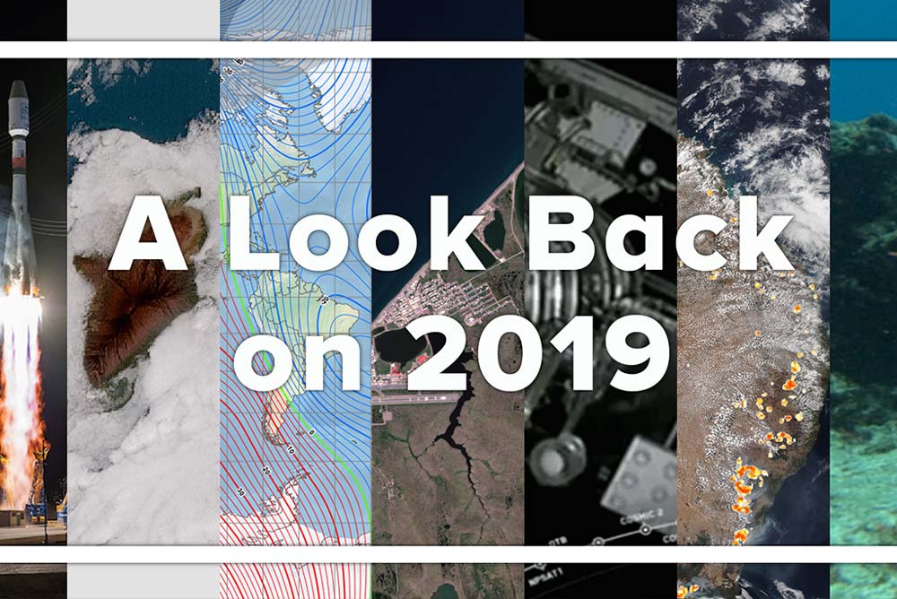
December 29, 2020: 50 Satellite Images from 50 Years of NOAA
![GOES-16 view of Hurricane Laura on Aug. 26, 2020.]()
GOES-16 view of Hurricane Laura on Aug. 26, 2020. Throughout 2020, NOAA celebrated its golden anniversary as one of the world’s premier science agencies—that’s 50 years of science, service, and stewardship. As part of this milestone, NOAA’s Satellite and Information Service is looking back at 50 years of images from space. These images represent the whole spectrum of what Earth-observing satellites provide: life-saving weather information, essential atmospheric and environmental data, critical hurricane updates, near-real-time wildfire detection, and much more.
-
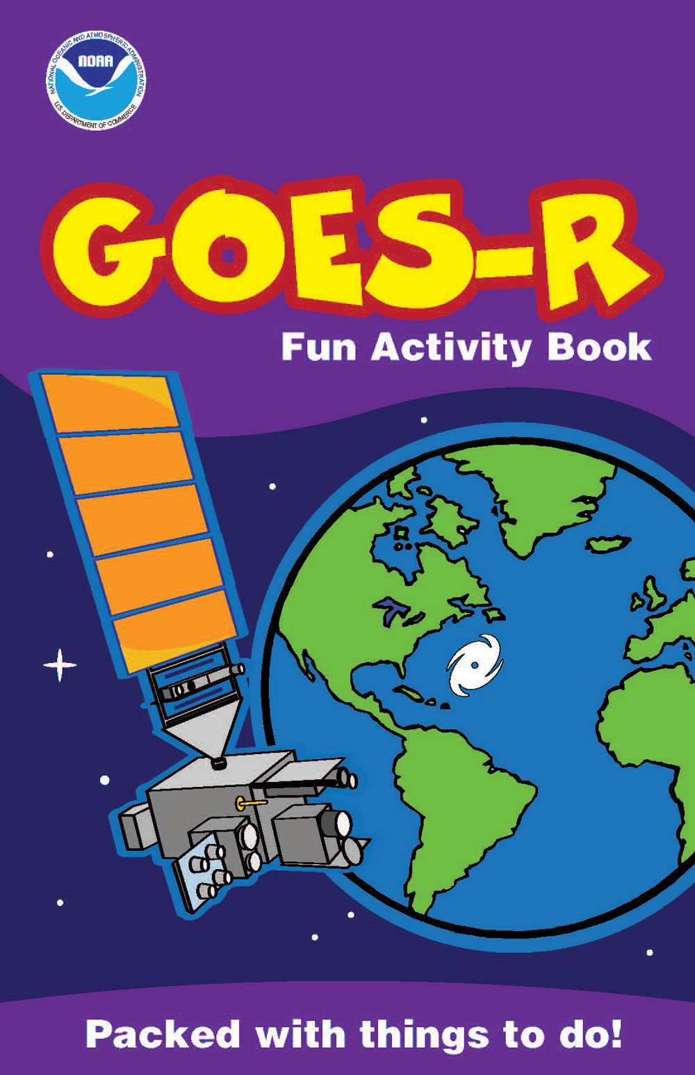
December 17, 2020: GOES-R Fun Activity Book
![GOES-R Fun Activity Book]()
Have fun learning about weather and satellites with a new GOES-R activity book full of puzzles, coloring pages, and other activities!
-
December 17, 2020: Scavenger Hunt: Learn All About the Weather!
![Scavenger Hunt: Learn All About the Weathe]()
Want to send your students on a quest for weather knowledge? Use our weather scavenger hunt in your next lesson! This new activity sends students on a quest for weather knowledge. Your task is to go on a scavenger hunt to learn all about weather–from snowflakes to firestorms, to hurricanes and many things in between! In this activity, you will adventure between articles on the NOAA SciJinks website, learning all about Earth’s many weather phenomena and gathering the missing words or phrases needed to assemble a secret word.
December

-
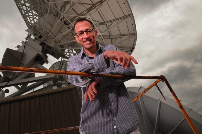
November 30, 2020: A NOAA Expert Answers Questions About the Historical 2020 Hurricane Season
![photo of Jim Kossin]()
Jim Kossin. Credit: Space Science and Engineering Center/Greg Anderson Photography Jim Kossin is an atmospheric research scientist at NOAA’s Center for Weather and Climate, part of NOAA’s National Centers for Environmental Information (NCEI). His research focuses on extreme storms—in particular tropical cyclones (hurricanes, typhoons)—and their relationship with climate and climate change. The NOAA Satellites team recently sat down with Jim to look back at the record-breaking 2020 Atlantic Hurricane Season as it draws to a close.
-
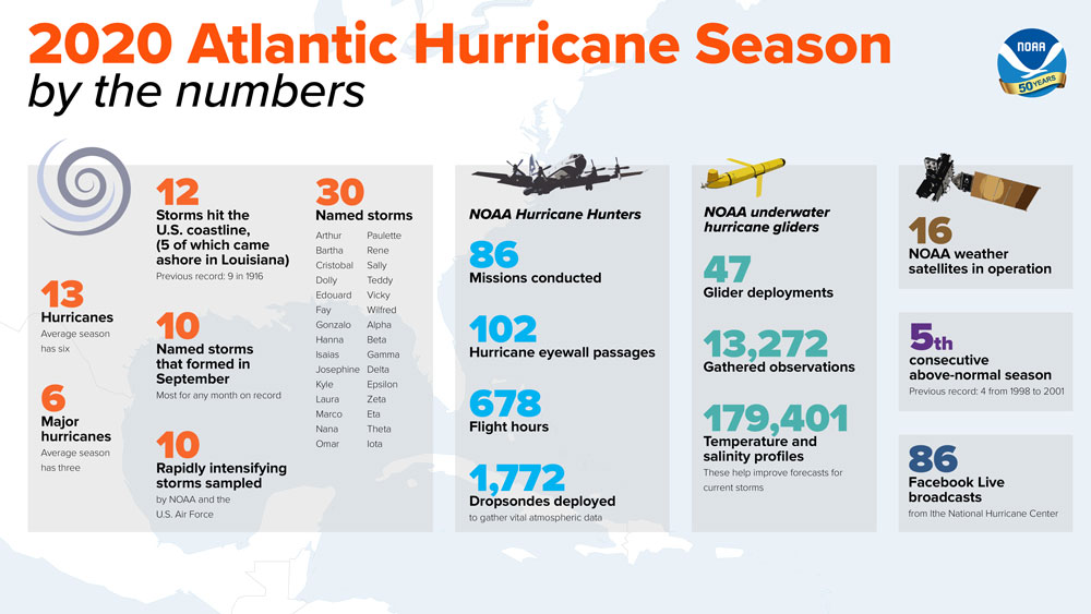
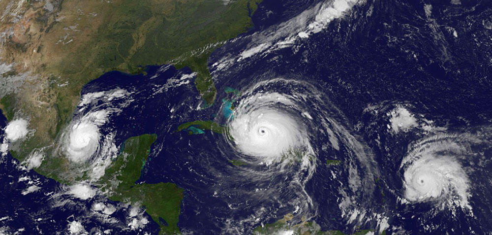
November 24, 2020: Record-breaking Atlantic Hurricane Season Draws to an End
![This infographic highlights key facts and statistics from the 2020 Atlantic Hurricane Season (at the time of publishing on November 24).]()
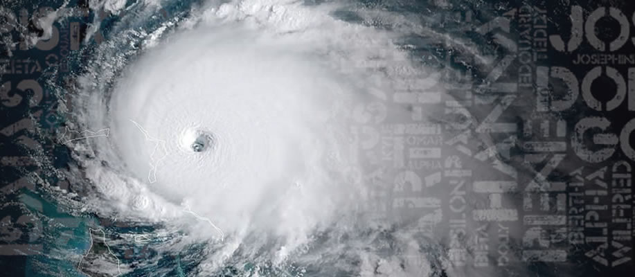
This infographic highlights key facts and statistics from the 2020 Atlantic Hurricane Season (at the time of publishing on November 24). The historic 2020 Atlantic hurricane season is drawing to a close. NOAA’s seasonal hurricane outlooks accurately predicted a high likelihood of an above-normal season with a strong possibility of it being extremely active. In total, the 2020 season produced 30 named storms (top winds of 39 mph or greater), of which 13 became hurricanes (top winds of 74 mph or greater), including six major hurricanes (top winds of 111 mph or greater). This is the most storms on record, surpassing the 28 from 2005, and the second-highest number of hurricanes on record. While the official hurricane season concludes on November 30, tropical storms may continue to develop past that day.
-
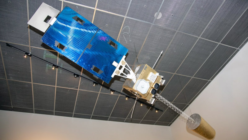
November 17, 2020: GOES Instruments Find a Home at the Smithsonian
![GOES-N Series satellite model located in the lobby of NOAA’s Satellite Operations Facility (NSOF) in Suitland, MD.]()
GOES-N Series satellite model located in the lobby of NOAA’s Satellite Operations Facility (NSOF) in Suitland, MD. NOAA’s Geostationary Operational Environmental Satellites (GOES) have a long history of monitoring the Earth’s ever-changing weather from above. Now, some of that history will be put on display at the Smithsonian’s Air and Space Museum in Washington, DC. Two instruments from GOES-Q have been sitting in storage for years, essentially collecting dust instead of weather data. GOES-Q was originally designed to be part of the GOES-N Series. However, because the existing satellites were performing well past their expected lifetimes, construction of the GOES-Q satellite was cancelled in 2002 after its flight imager and sounder were already manufactured. This year they were retired to the National Collection of the Smithsonian Institute, where they will be incorporated into two modernized exhibits that are being constructed at the Air and Space Museum, which is currently undergoing a major seven-year renovation.
-
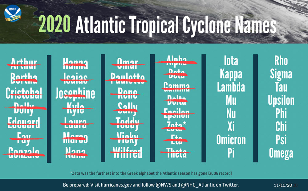
November 10, 2020: 2020 Atlantic Hurricane Season Takes Infamous Top Spot for Busiest on Record
![The list of named storms that have occurred during the Atlantic hurricane season as of November 9, 2020.]()
The list of named storms that have occurred during the Atlantic hurricane season as of November 9, 2020. With less than a month remaining in the Atlantic hurricane season, the formation of Subtropical Storm Theta on November 10 over the northeastern Atlantic Ocean made the 2020 season the most active on record. Theta — the 29th named storm of the Atlantic season — breaks the record for the highest number of tropical/subtropical storms in a single year. The previous record of 28 storms was set in 2005. Official records date to 1851. The Atlantic hurricane season officially ends on November 30, but additional storms could develop beyond that date. Forecasters at NOAA’s National Hurricane Center continuously monitor the tropics for storm development and activity.
November
-
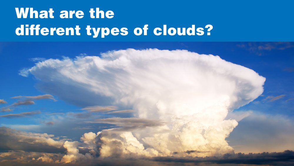
October 30, 2020: What are the Different Types of Clouds?
![What are the Different Types of Clouds?]()
Clouds are often one of the first things we notice when we look up into the sky. They’re all made of water droplets or ice crystals, but they can take on lots of different appearances. Different types of clouds include cumulus, altocumulus, cirrocumulus, altostratus, nimbostratus and cumulonimbus clouds. Learn more about different types of clouds in a new video from NOAA SciJinks.
-
October 26, 2020: Late-Season Hurricanes Can Bring Their Own October Surprise
![Hurricane Michael approaching Florida on Oct. 10, 2018.]()
Hurricane Michael approaching Florida on Oct. 10, 2018. With a little more than a month left in the official Atlantic Hurricane Season, NOAA’s Satellite and Information Service reminds you not to let your guard down. Despite being at the end of the season’s peak window, late October has occasionally produced devastating hurricanes that have hit the United States and elsewhere. Late-October hurricanes can unleash a mighty fury; and when they do, NOAA satellites are continuously monitoring their track and strength.
-
October 21, 2020: Beginner’s Guide to GOES-R Series Data
![GOES-16 Full Disk image of ABI L1b channel 3 radiances on May 29th, 2020, visualized using Python.]()
GOES-16 Full Disk image of ABI L1b channel 3 radiances on May 29th, 2020, visualized using Python. A new resource, “Beginner’s Guide to GOES-R Series Data,” is now available to help new end-users acquire, analyze and visualize GOES-R L1b and L2+ data products. This toolkit includes an overview of the GOES-R Series and data products, how to access GOES-R data and imagery, how to display the data, and frequently asked questions.
-
October 19, 2020: Third Quarter 2020 GOES-R Program Newsletter
![The GOES-T magnetometer is installed on the spacecraft. Credit: Lockheed Martin]()
The GOES-T magnetometer is installed on the spacecraft. Credit: Lockheed Martin The GOES-R Series Program quarterly newsletter for July – September 2020 is now available. The GOES-R Program continues to make outstanding progress while overcoming current challenges as a team. GOES-T is fully assembled and in thermal vacuum testing. The ground system server replacement is now fully underway. GOES-16 and 17 are providing critical data for the unprecedented fire conditions in the Western U.S. and record-breaking Atlantic hurricane season. GEO-XO planning continues to move forward. The program is working to determine initial Level 1 requirements by the end of this calendar year and preparing to issue the RFP for the GEO-XO Imager Phase A study contracts in November. The team continues to engage users and stakeholders to gather feedback on their needs from future NOAA satellite systems through workshops, surveys, listening sessions, and interviews. A successful Community Meeting on NOAA Satellites closed out the quarter, bringing together more than 1,000 people to share their input on what the GEO-XO system could be.
-
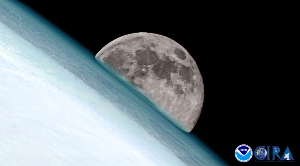
October 1, 2020: An Ode to the Moon: How NOAA Satellites Capture Earth’s Satellite
![GOES-17 captured the moon rising over the northeast edge of Earth on March 6, 2020]()
GOES-17 captured the moon rising over the northeast edge of Earth on March 6, 2020. October 2020 will offer a rare celestial treat—a full Harvest Moon on October 1 and a second full “Blue Moon” on Halloween night. While Blue Moons occur about every two or three years, the last time there was a Blue Moon on October 31 in all U.S. time zones was back in 1944. NOAA’s satellites have a unique relationship with Earth’s natural satellite. They use the moon’s reflected sunlight, gravitational pull, and orbital position to their advantage--and although not specifically designed to do so, NOAA satellites occasionally catch breathtaking glimpses of the moon from their perspective in space. Both GOES-16 and GOES-17 scan the moon regularly to help calibrate the Advanced Baseline Imager’s visible channels. The moon is a very stable and predictable target with no atmosphere.
October

-
September 30, 2020: NOAA Team Honored with Gears of Government President’s Award
![NOAA Weather Satellite Team]()
A team of scientists and engineers from NOAA’s Satellite and Information Service (NESDIS) has been awarded the Gears of Government President’s Award for leadership and excellence in restoring the functionality of NOAA’s new GOES-17 weather satellite, following a major post-launch anomaly. Pam Sullivan, Dan Lindsey, Harry Cikanek, Joseph Pica, and Vanessa Griffin used a coordinated approach with innovative techniques to restore the satellite’s ability to observe critical weather conditions across the Western Hemisphere, such as severe storms, hurricanes, fires, and volcanic activity, with minimal data loss. This team’s response to the crisis restored the value of the nation’s $1 billion investment and provided a vital asset for meeting the National Weather Service’s mission.
-
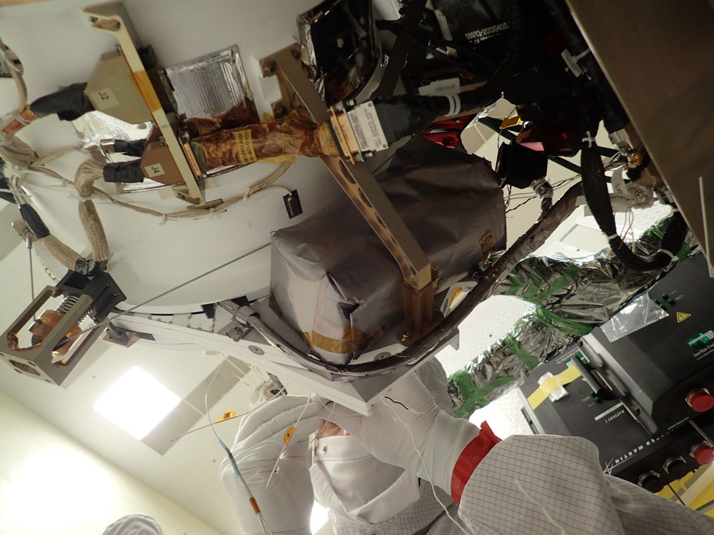
September 29, 2020: NOAA’s GOES-T Satellite Undergoes Testing to Simulate Launch and Orbit Conditions
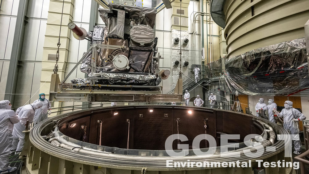
GOES-T is lifted up to the thermal vacuum chamber. Credit: Lockheed Martin GOES-T, the third satellite in NOAA’s GOES-R Series, is fully assembled and beginning a set of rigorous tests to ensure it can withstand the harsh conditions of launch and the space environment in which it will reside once it reaches geostationary orbit 22,236 miles above Earth. GOES-T recently began thermal vacuum testing, which simulates the extreme temperatures of launch and the space environment. A new feature story highlights the environmental, mechanical, end-to-end, and electromagnetic tests GOES-T will undergo to prepare it for launch. GOES-T is currently scheduled to launch in December 2021 from Cape Canaveral Air Force Station in Florida.
-
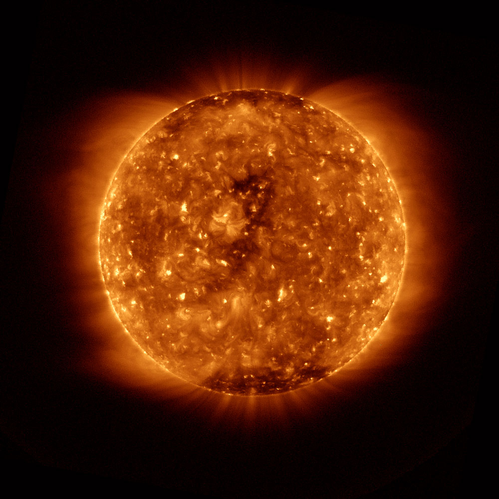
September 15, 2020: Solar Cycle 25 is Here
![Solar minimum – the period when the sun is least active – as seen by the Solar Ultraviolet Imager aboard GOES East on Dec. 15, 2019. Credit: NOAA.]()
Solar minimum – the period when the sun is least active – as seen by the Solar Ultraviolet Imager aboard GOES East on Dec. 15, 2019. Credit: NOAA. NOAA announced on September 15, 2020 that the solar minimum between Solar Cycles 24 and 25 – the period when the sun is least active – happened in December 2019. We are now officially in Solar Cycle 25 with peak sunspot activity expected in 2025, according to the Solar Cycle 25 Prediction Panel, co-chaired by NOAA and NASA. Solar Cycle 24 was average in length, at 11 years, and had the 4th-smallest intensity since regular record keeping began with Solar Cycle 1 in 1755. It was also the weakest cycle in 100 years. Solar maximum occurred in April 2014 with sunspots peaking at 114 for the solar cycle, well below average, which is 179. For the past eight months, activity on the Sun has steadily increased, indicating we transitioned to Solar Cycle 25. Solar Cycle 25 is forecast to be a fairly weak cycle, the same strength as cycle 24. Learn more about what it means to be in a new solar cycle.
-
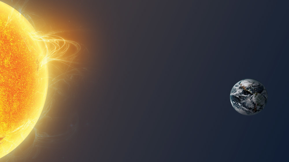
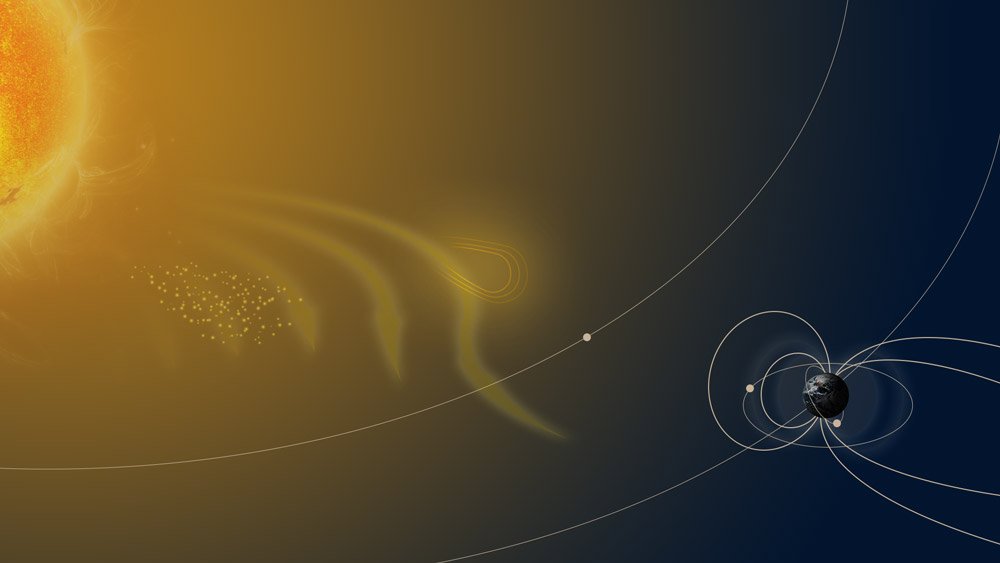
September 15, 2020: What’s the Big Deal About Solar Cycles?
![This graphic depicts the Sun and Earth in space. Credit: NOAA]()
This graphic depicts the Sun and Earth in space. Credit: NOAA The Sun is Earth’s nearest star—a giant orb of hydrogen and helium about 93 million miles away. To many people, it looks like the same constant ball of light day after day as it moves across the sky. However, our Sun actually goes through a cycle of increasing and decreasing activity that lasts for about 11 years.
-
September 15, 2020: Top Five Times Solar Activity Affected Earth
![This graphic depicts space weather. Credit: NOAA]()
This graphic depicts space weather. Credit: NOAA Over the course of the Sun’s 11-year solar cycle, the star goes through a period of increased and decreased activity. When this activity ramps up, sometimes phenomena such as solar flares and coronal mass ejections (CMEs), where massive amounts of radiation and solar particles erupt out from the Sun’s surface, can wreak havoc if our planet happens to be in the way of the blast. Learn about five notable instances when this has occurred and their effects.
-
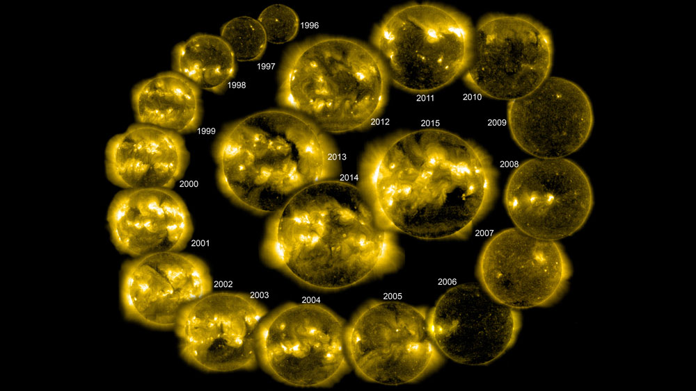
September 15, 2020: How to Safely Stare at the Sun: SOHO, SDO, and GOES-R Instruments
![NASA Solar and Heliospheric Observatory (SOHO) imagery of the Sun from 1996 through 2015. Credit: SOHO/NASA/ESA.]()
NASA Solar and Heliospheric Observatory (SOHO) imagery of the Sun from 1996 through 2015. Credit: SOHO/NASA/ESA NOAA’s science isn’t just limited to Earth and its atmosphere. NOAA’s reach goes from the surface of the Sun to the depths of the ocean floor as we work to keep the public informed of the changing environment around them. So, what sort of instruments help scientists detect what’s going on in the Sun in the first place?
-
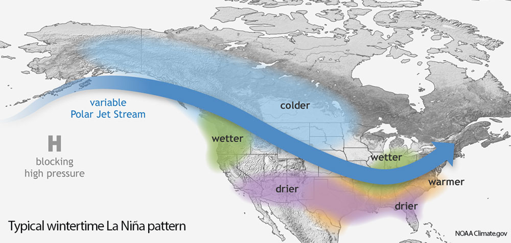
September 10, 2020: La Nina Develops During Peak of Hurricane Season
![Typical wintertime La Nina pattern.]()
Typical wintertime La Nina pattern. A La Nina climate pattern has developed and is likely to persist through the winter, according to an advisory issued on September 10, 2020, by NOAA’s Climate Prediction Center. La Nina — translated from Spanish as “little girl”— is a natural ocean-atmospheric phenomenon marked by cooler-than-average sea surface temperatures across the central and eastern Pacific Ocean near the equator. La Nina can contribute to an increase in Atlantic hurricane activity by weakening the wind shear over the Caribbean Sea and tropical Atlantic Basin, which enables storms to develop and intensify.
-
September 2, 2020: Why Does the Wind Blow?
![Google’s new wildfire-mapping feature, created using GOES data, includes fire boundaries and official updates.]()
Wind is a part of weather that we’ve all experienced at one time or another. And whether it’s a welcome breeze on a hot day, or a destructive gust during a storm, it all starts in the same way: differences in air pressure. Learn more about what causes wind and how satellites measure it in a new video from NOAA SciJinks.
September

-
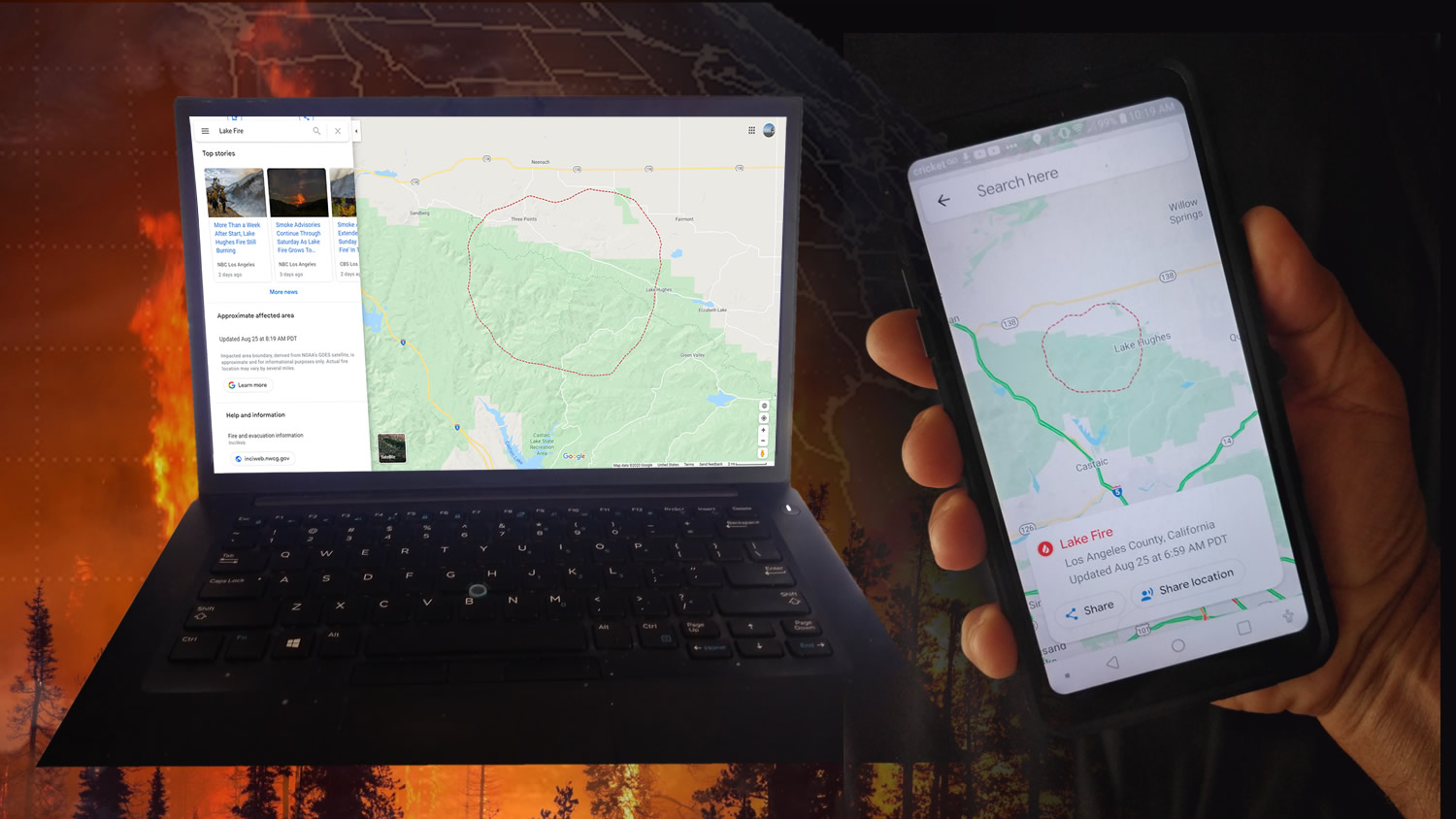
August 28, 2020: GOOGLE HARNESSES THE POWER OF GOES IN NEW FIRE MAPS
![Google’s new wildfire-mapping feature, created using GOES data, includes fire boundaries and official updates.]()
Google’s new wildfire-mapping feature, created using GOES data, includes fire boundaries and official updates. NOAA’s GOES-16 (GOES East) and GOES-17 (GOES-West) satellites are known for providing critical data to incident meteorologists, emergency managers, and first responders to detect fires, identify their locations, and track them in near-real-time. Now, they’re also helping show the public where active wildfires are located so they can avoid dangerous areas. A new Google feature uses satellite data to guide the mapping of fire boundaries and assist in providing official updates and alerts. The maps are updated hourly to provide the latest available information. The advanced data and information GOES-16 and GOES-17 provide continue to make possible new and innovative ways to help keep us informed and stay safe.
-
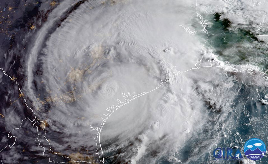
August 17, 2020: Record-Breaking Atlantic Hurricane Season Underway
![Record-breaking Atlantic hurricane season underway.]()
Record-breaking Atlantic hurricane season underway. Atlantic hurricane season got off to an early and busy start this year and has been breaking records along the way. On August 6, NOAA issued its updated 2020 Atlantic Hurricane Season Outlook, predicting the possibility of an “extremely active” Atlantic Basin hurricane season. So far, the 2020 season has indeed been an active one, with eleven named storms through August 14. In fact, 2020 is shaping up to be one of the most active Atlantic hurricane seasons on record. As we head into the peak of hurricane season, a new feature story takes a look at the record-breaking Atlantic hurricane season so far and the critical information NOAA satellites provide for forecasting and tracking tropical storms and hurricanes.
-
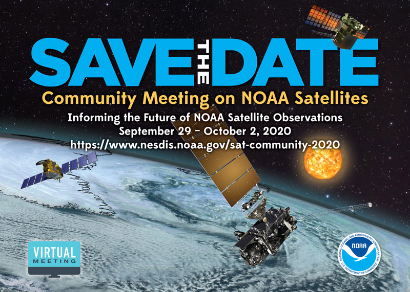
August 11, 2020: Save the Date! Community Meeting on NOAA Satellites
![Save the Date! Community Meeting on NOAA Satellites]()
NOAA is currently formulating plans for the satellite programs that will follow GOES-R, JPSS, and SWFO and be operational in 2030 and beyond. We would like to hear from you – our data users, partners, and stakeholders – to help inform these important decisions. Please join us September 29 – October 2 for a virtual 2020 Community Meeting on NOAA Satellites, where you will hear about the strategic objectives of NESDIS as well as current activities and future plans for the Geostationary and Extended Orbits (GEO-XO), Low-Earth Orbit (LEO), and Space Weather programs.
Session topics will also include NOAA ground system evolution, updates from international meteorological agencies, and recent feedback from our users about what they need from future observing systems. We will have dedicated discussion time throughout the meeting in order to hear from you, and we are planning “lean in” sessions where we will invite community members to share their thoughts about NOAA’s future observing systems. Visit the 2020 Community Meeting on NOAA Satellites website for more information and to register for the meeting.
-
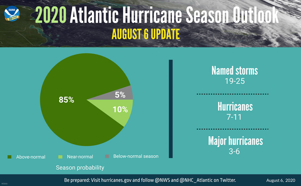
August 6, 2020: “Extremely Active” Hurricane Season Possible for Atlantic Basin
![A summary infographic showing hurricane season probability and numbers of named storms predicted from NOAA's updated 2020 Atlantic Hurricane Season Outlook.]()
A summary infographic showing hurricane season probability and numbers of named storms predicted from NOAA's updated 2020 Atlantic Hurricane Season Outlook. Atmospheric and oceanic conditions are primed to fuel storm development in the Atlantic, leading to what could be an “extremely active” season, according to forecasters with NOAA’s Climate Prediction Center, a division of the National Weather Service. On August 6, 2020, the agency released its annual August update to the Atlantic Hurricane Season Outlook, initially issued in May. The 2020 Atlantic hurricane season is already off to a rapid pace with a record-setting nine named storms so far and has the potential to be one of the busiest on record. The updated outlook calls for 19-25 named storms (winds of 39 mph or greater), of which 7-11 will become hurricanes (winds of 74 mph or greater), including 3-6 major hurricanes (winds of 111 mph or greater). This update covers the entire six-month hurricane season, which ends Nov. 30, and includes the nine named storms to date
August
-
July 9, 2020: Second Quarter 2020 GOES-R Program Newsletter
![Technicians at Lockheed Martin conduct GOES-T satellite integration activities.]()
Technicians at Lockheed Martin conduct GOES-T satellite integration activities. Credit: Lockheed Martin The GOES-R Series Program quarterly newsletter for April – June 2020 is now available. As we continue operations with most personnel working remotely and on-site work limited to mission critical activities, the GOES-R team continues to shine. We delivered the GOES-T ABI and GLM instruments and integrated them with the spacecraft. We completed testing of the Goddard Magnetometers and they will ship this month. GOES-T is preparing for environmental testing. We are restarting work at NOAA operational facilities to support current GOES-16/17 operations, GOES-T launch preparations, and a ground system upgrade. Our satellites continue to provide critical data and imagery to forecasters.
July

-
June 29, 2020: Two Orbits, One Mission: NOAA Satellites Work Together to Provide Critical Data for Weather Forecasts
![Polar and geostationary satellite orbits]()
Geostationary and polar-orbiting satellites work together to provide a complete picture of what’s happening on Earth NOAA maintains a fleet of satellites to monitor Earth’s weather, environment and climate. These satellites provide essential data that feed forecasts and warn us of severe weather and environmental hazards. There are two primary types of satellites used for weather forecasts: geostationary and polar-orbiting. Together, they make a powerful team. Each provides critical information about severe storms, tornadoes, hurricanes, snowstorms, and flooding, as well as wildfires, smoke plumes, volcanic eruptions, and dust storms. Different vantage points, imaging frequency, and instrumentation provide complementary measurements for a complete picture of what’s happening on Earth.
-
June 25, 2020: World Meteorological Organization Certifies Lightning Megaflash Records
GOES-16 (GOES East) Geostationary Lightning Mapper animation of the recording-breaking lighting flash in Brazil on October 31, 2018. Credit: NOAA On June 25, 2020, the World Meteorological Organization (WMO) certified two new lightning “megaflash” records. A panel of experts confirmed new world records for the longest reported distance for a single lightning flash (440 miles) in Brazil in 2018, and the longest duration of a single lightning flash (16.73 seconds) in Argentina in 2019. Data from the GOES-16 Geostationary Lightning Mapper (GLM) was used to verify the records.
-
June 24, 2020: The Saharan Air Layer: What is it? Why does NOAA track it?
GOES-16 (GOES East) monitored a large plume of Saharan dust as it reached the Caribbean on June 22, 2020. As we move through the 2020 Atlantic Hurricane Season, you will no doubt hear a lot about the Saharan Air Layer (SAL) —a mass of very dry, dusty air that forms over the Sahara Desert during the late spring, summer and early fall. This layer can travel and impact locations thousands of miles away from its African origins. NOAA Satellite and Information Service sat down with scientist Dr. Jason Dunion, a University of Miami hurricane researcher working with NOAA's Atlantic Oceanographic and Meteorological Laboratory, to talk about the SAL. They also discussed how forecasters and scientists monitor and study the SAL using data from several satellites, including GOES-16, NOAA-20, and the NOAA/NASA Suomi-NPP.
-
June 22, 2020: Satellites Have Drastically Changed How We Forecast Hurricanes
This video looks at advances in hurricane forecasting, with a focus on the contributions from weather satellites. Credit: NASA/ Jefferson Beck The powerful hurricane that struck Galveston, Texas, on September 8, 1900, killing an estimated 8,000 people and destroying more than 3,600 buildings, took the coastal city by surprise. A new video looks at advances in hurricane forecasting in the 120 years since, with a focus on the contributions from weather satellites. A fleet of Earth-observing satellites, including those from the Joint Polar Satellite System (JPSS) and Geostationary Operational Environmental Satellite series (GOES-R), provides remarkable advances in hurricane forecasting. This satellite technology has allowed us to track hurricanes – their location, movement and intensity.
-
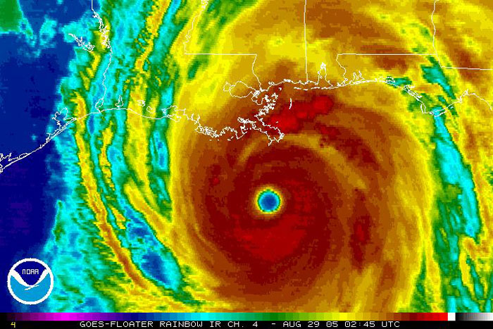
June 8, 2020: The 2005 Atlantic Hurricane Season, Fifteen Years Later
![Hurricane Katrina, captured by GOES-12 on August 29, 2005.]()
Hurricane Katrina, captured by GOES-12 on August 29, 2005. The incredible 2005 Atlantic hurricane season broke many long-standing records. It began on June 8, with Tropical Storm Arlene, one of 27 named storms that formed during that unprecedented hurricane season. Since 2005, a new generation of geostationary and polar-orbiting satellites has provided NOAA with state-of-the-art data and imagery for tropical storms and hurricanes. Take a look back at that record-breaking season—and see what NOAA satellites are providing for 2020.
-
June 1, 2020: Cloudy Days and Solar Arrays: GOES-16 and GOES-17 Data Support Solar Energy Forecasts
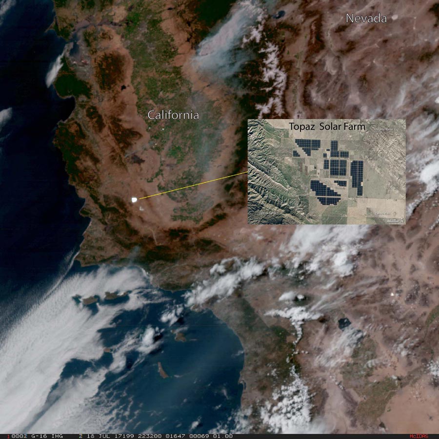
![GOES-16 true color imagery over California collected on July 18, 2017 shows the reflection of sunlight off solar panels at the Topaz Solar Farm (inset) seen in the bright white patch noted in the imagery. Credit: CIRA]()
GOES-16 true color imagery over California collected on July 18, 2017 shows the reflection of sunlight off solar panels at the Topaz Solar Farm (inset) seen in the bright white patch noted in the imagery. Credit: CIRA GOES satellites are known for providing critical data to weather forecasters, but the information they collect can also help the renewable energy sector. The detailed data GOES-16 (GOES East) and GOES-17 (GOES-West) provide about clouds is useful for forecasting solar energy production. Clouds affect the output of ground-based solar power generation systems. Information from the satellites can be used to track the motion of clouds, predict the passage of cloud shadows, and estimate the amount of sunlight reaching solar energy systems. This data is crucial for harnessing solar energy and efficiently delivering it to consumers.
-
June 1, 2020: Hurricane forecast models get a boost from new satellite data
![A summary infographic showing hurricane season probability and numbers of named storms predicted from NOAA's 2020 Atlantic Hurricane Season Outlook]()
GOES-16 winds generated over Hurricane Irma on September 6, 2017, overlaid on GOES-16 visible imagery. Hurricane forecast models got an upgrade this year, thanks to new satellite data. For the first time, GOES-16 (GOES East) and GOES-17 (GOES-West) data are being fed into NOAA’s Hurricane Weather Research and Forecasting (HWRF) computer model used to forecast the track and intensity of tropical cyclones. This year, high-resolution wind data from GOES-16 and GOES-17 is included in the model. The ability to characterize the wind fields in and around a hurricane is crucial to predicting future storm motion and intensity.
June


-
May 29, 2020: First Significant Solar Activity Since 2017
GOES-16 Solar Ultraviolet Imager (SUVI) captured two solar flares on May 29, 2020. The GOES-16 (GOES East) Solar Ultraviolet Imager (SUVI) observed two solar flares on the morning of May 29, the first significant solar activity observed since October 2017. This may be a sign of the sun's solar cycle ramping up and becoming more active. As the sun moves through its natural 11-year cycle, in which its activity rises and falls, sunspots rise and fall in number, too. NASA and NOAA track sunspots in order to determine, and predict, the progress of the solar cycle — and ultimately, solar activity. Currently, scientists are paying close attention to the sunspot number as it's key to determining the dates of solar minimum, which is the official start of Solar Cycle 25. It takes at least six months of solar observations and sunspot-counting after a minimum to know when it's occurred. Because that minimum is defined by the lowest number of sunspots in a cycle, scientists need to see the numbers consistently rising before they can determine when exactly they were at the bottom. That means solar minimum is an instance only recognizable in hindsight: It could take six to 12 months after the fact to confirm when minimum has actually passed. This new sunspot activity could be a sign that the sun is possibly revving up to the new cycle and has passed through minimum.
-
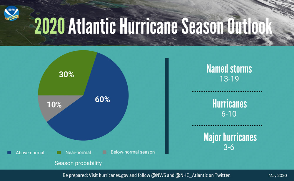
May 21, 2020: Busy Atlantic Hurricane Season Predicted for 2020
![A summary infographic showing hurricane season probability and numbers of named storms predicted from NOAA's 2020 Atlantic Hurricane Season Outlook]()
A summary infographic showing hurricane season probability and numbers of named storms predicted from NOAA's 2020 Atlantic Hurricane Season Outlook. An above-normal 2020 Atlantic hurricane season is expected, according to forecasters with NOAA’s Climate Prediction Center, a division of the National Weather Service. The outlook predicts a 60% chance of an above-normal season, a 30% chance of a near-normal season and only a 10% chance of a below-normal season. The combination of several climate factors is driving the strong likelihood for above-normal activity in the Atlantic this year. The Atlantic hurricane season runs from June 1 through November 30.
-
May 19, 2020: Link Between Earth’s Heat and Hurricane Strength Grows
![Hurricane Harvey over Texas on August 26, 2017, as seen by GOES-16.]()
Hurricane Harvey over Texas on August 26, 2017, as seen by GOES-16. Researchers from NOAA and the Cooperative Institute for Meteorological Satellite Studies have greater confidence that warming surface temperatures and increasing tropical cyclone intensity appear to go hand-in-hand. A new study published in the Proceedings of the National Academy of Sciences (PNAS) indicates a significant global increase in hurricane intensity over a four-decade period, showing the emergence of more significant findings than previous work. New algorithms indicate future years could be among the warmest, and according to a statistical analysis, the year 2020 is very likely to rank among the five warmest years on record.
-
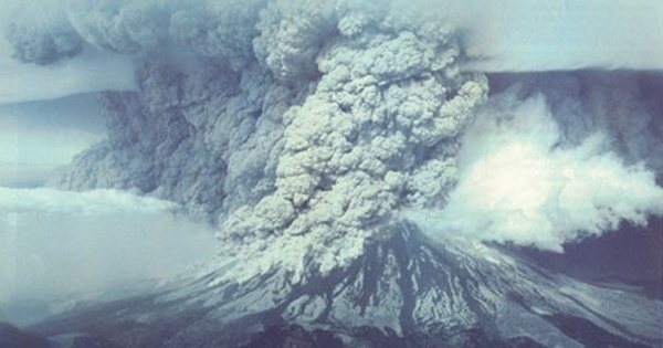
May 18, 2020: 40th Anniversary of the Eruption of Mt. St. Helens
![Eruption of Mt. St. Helens on May 18, 1980. Photograph by Joseph Rosenbaum, courtesy USGSEruption of Mt. St. Helens on May 18, 1980. Photograph by Joseph Rosenbaum, courtesy USGS]()
Eruption of Mt. St. Helens on May 18, 1980. Photograph by Joseph Rosenbaum, courtesy USGS On May 18, 1980, iconic Mount St. Helens erupted in southwestern Washington state in the deadliest and most economically destructive volcanic event in U.S. history. In a new feature story, take a look back at the eruption as viewed by GOES-3 and see how far satellite monitoring of volcanic activity has come since then. This feature also highlights some of the most compelling volcano imagery NOAA has collected over the last four decades.
-
May 4, 2020: Climate change has been influencing where tropical cyclones rage
![GOES-16 imagery of hurricanes Katia, Irma and Jose on September 28, 2017.]()
GOES-16 imagery of hurricanes Katia, Irma and Jose on September 28, 2017. While the global average number of tropical cyclones each year has not budged from 86 over the last four decades, climate change has been influencing the locations of where these deadly storms occur, according to new NOAA-led research published in Proceedings of the National Academy of Science. New research indicates that the number of tropical cyclones has been rising since 1980 in the North Atlantic and Central Pacific, while storms have been declining in the western Pacific and in the South Indian Ocean. Three forces are influencing where storms are hitting: greenhouse gases, particulate pollution and other aerosols, and volcanic eruptions.
-
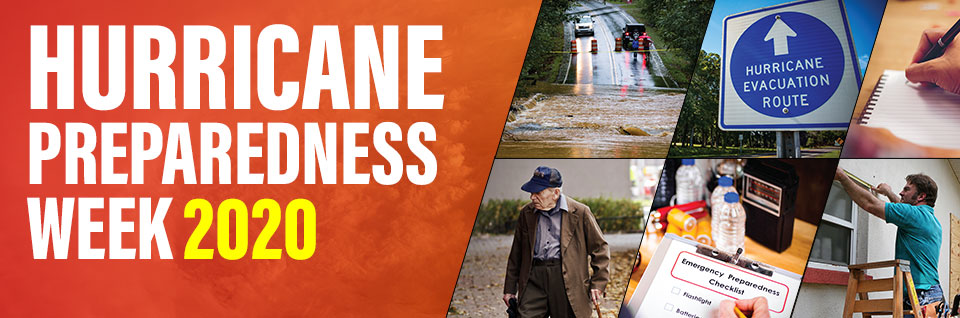
May 3-9, 2020: Hurricane Preparedness Week
![2020 Hurricane Preparedness Week]()
2020 Hurricane Preparedness Week It's National Hurricane Preparedness Week. Each day has a preparedness theme with important tips to help you prepare. Be ready for hurricane season by determining your personal hurricane risk, finding out if you live in a hurricane evacuation zone, and reviewing/updating insurance policies. You can also make a list of items to replenish hurricane emergency supplies and start thinking about how you will prepare your home for the coming hurricane season. Hurricane season begins May 15 in the eastern Pacific, and June 1 for the central Pacific and Atlantic. Visit the National Weather Service Hurricane Preparedness webpage to learn about hurricane hazards and safety and learn how to prepare for the upcoming hurricane season.
May
-
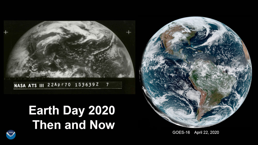
April 22, 2020: Still Inspiring After 50 Years: Earth Day Images Then and Now
![Earth Day then and now. ATS-1 image of Earth from April 22, 1970 (left) and GOES-16 full disk on April 22, 2020 (right).]()
Earth Day then and now. ATS-1 image of Earth from April 22, 1970 (left) and GOES-16 full disk on April 22, 2020 (right). April 22 marks the 50th anniversary of the first Earth Day! Shortly after the first Earth Day, the National Oceanic and Atmospheric Administration (NOAA) was created along with the U.S. Environmental Protection Agency (EPA). The Clean Air, Clean Water, and Endangered Species Acts were also passed. Today, more than 1 billion people in 193 countries participate in Earth Day activities, raising awareness about critical environmental issues. In celebration of Earth Day, NOAA takes a look at just how far geostationary satellite technology has come since 1970, when the first geostationary satellite, ATS-1 was launched.
-
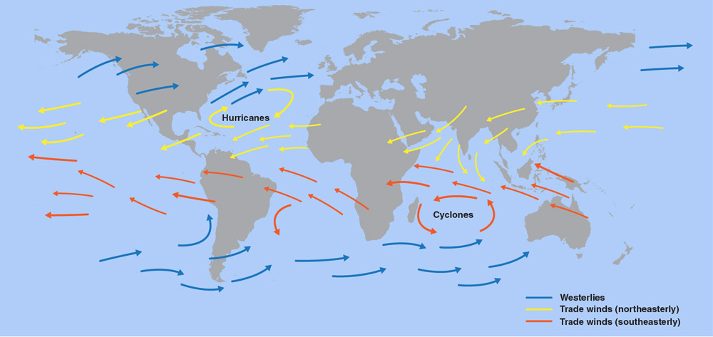
April 15, 2020: What are Trade Winds?
![GOES-16 (GOES East) ABI River Flood Areal Extent Product, NWS River Flood Warnings from April 10, 2020.]()
The trade winds blow from east to west near the equator. Credit: NASA/JPL-Caltech. A new article from NOAA SciJinks, published April 15, explains trade winds. Wind often blows in different directions, but many are quite predictable. For example, the trade winds are air currents closer to Earth’s surface that blow from east to west just north and south of the equator. The winds help ships travel west, and they can also steer storms such as hurricanes, too. GOES East keeps an eye on how trade winds impact the movement of hurricanes and tropical storms toward the southeastern United States.
-
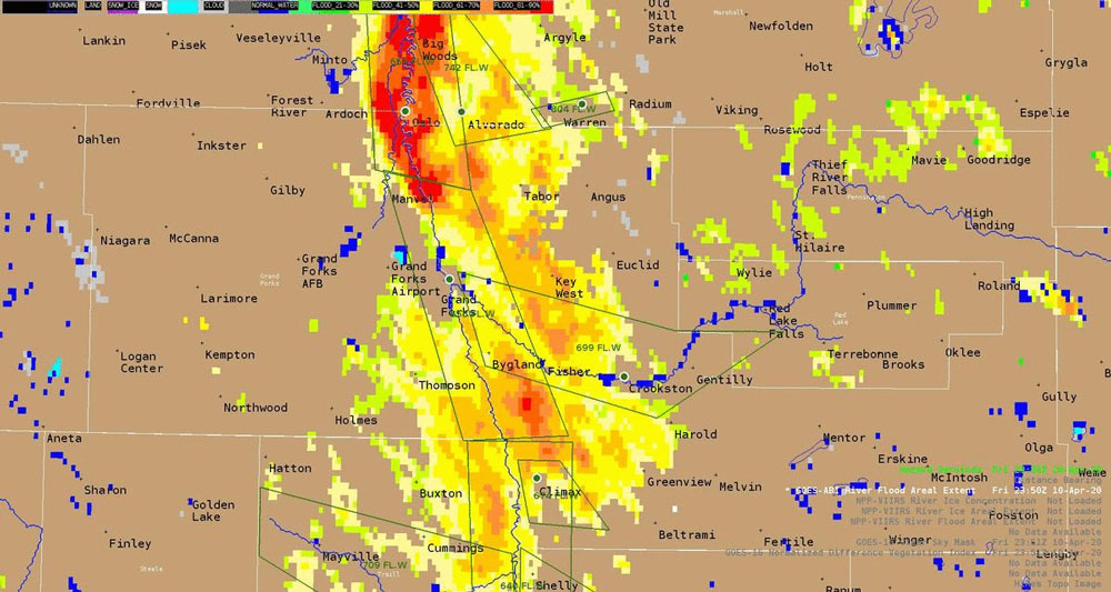
April 20, 2020: Applying GOES-16 Satellite Imagery to NWS Grand Forks Flood Operations
![TGOES-16 (GOES East) ABI River Flood Areal Extent Product, NWS River Flood Warnings from April 10, 2020.]()
GOES-16 (GOES East) ABI River Flood Areal Extent Product, NWS River Flood Warnings from April 10, 2020. Flooding within the Red River of the North basin straddling the North Dakota and Minnesota border is very common this time of year. On April 10, 2020, major flooding was occurring over much of the Red River and its tributaries due to seasonal snow melt. GOES-16 satellite imagery and river flood products aided the National Weather Service Grand Forks Weather Forecast operations by providing excellent details in gauging flooding impacts from river and overland flooding.
-
April 13, 2020: NESDIS Announces First Set of BAA Contract Awards
On April 13, 2020, NESDIS announced the first in a series of contract awards to develop mission, spacecraft and instrument concepts for future Earth observation capabilities. The new concepts NESDIS is considering in this initial round are atmospheric temperature and pressure sounding observations in low earth orbit (LEO) and broader mission approaches for geostationary earth orbits (GEO) and extended orbits (GEO-XO). NESDIS will use the results of these analyses to inform the design, acquisition, development, and launch of a cost-effective, agile satellite architecture to support NOAA’s mission in the coming decades.
These contracts follow a pair of Broad Agency Announcements NESDIS issued last Fall, calling for ideas from the commercial and research sector. After a formal review of the white papers over this past winter, NESDIS directed Requests for Proposals to selected entities. NESDIS will award additional contracts over the next month and anticipates completing these analyses this year.
-
April 7, 2020: First Quarter 2020 GOES-R Program Newsletter
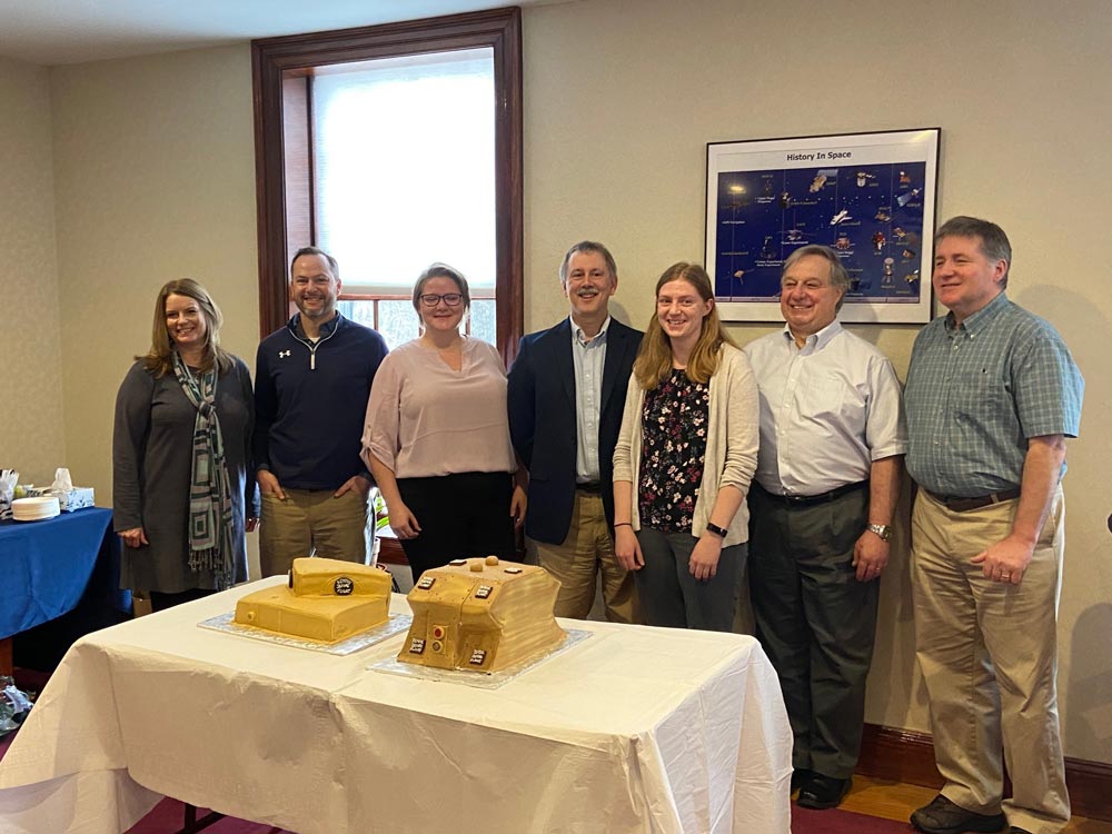
![The Space Environment In-Situ Suite (SEISS) team celebrates a successful GOES-U Pre-Shipment Review with cakes shaped like SEISS sensors.]()
The Space Environment In-Situ Suite (SEISS) team celebrates a successful GOES-U Pre-Shipment Review with cakes shaped like SEISS sensors. The GOES-R Series Program quarterly newsletter for January – March 2020 is now available. Our work environment changed dramatically in March with the arrival of COVID-19. With most personnel working remotely, and on-site work limited to mission-critical operations, we had to adapt how we accomplished our mission. No surprise that the GOES-R team rose to the challenge! Despite the uncertainty and changing work conditions, we continue to accomplish major program milestones.
-
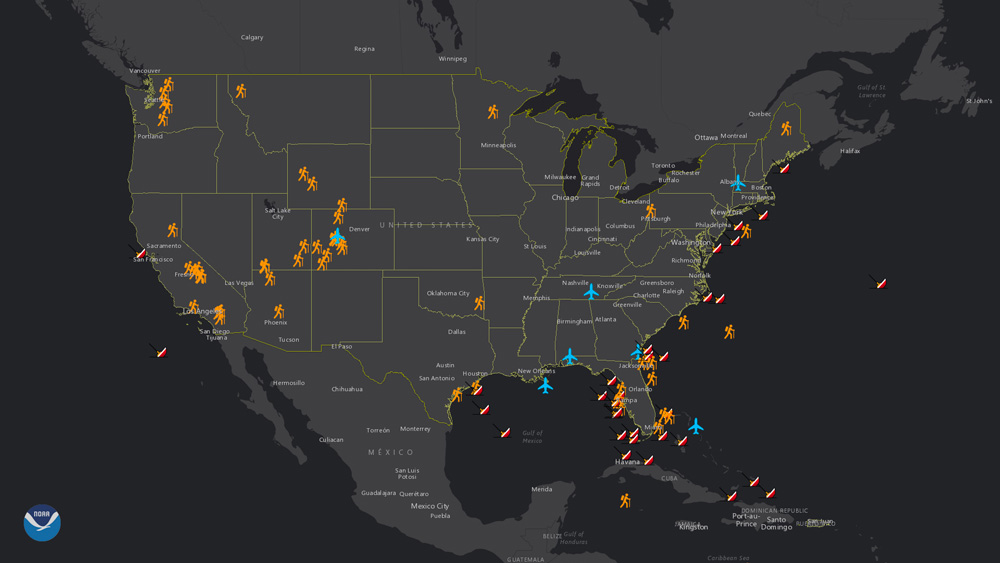
April 6, 2020: NOAA Celebrates SARSAT Beacon Awareness Day
![SARSAT rescues map, 2019. Credit: NOAA]()
SARSAT rescues map, 2019. Credit: NOAA The Search and Rescue Satellite Aided Tracking (SARSAT) system is recognized by emergency responders and related governmental organizations every year on April 6 because it tracks 406 MHz distress signals from transmitters and beacons from around the globe. In 2019, SARSAT helped rescue 421 people in and around the U.S. and its territories. NOAA’s fleet of polar-orbiting and geostationary satellites—such as the JPSS and GOES-R series— is part of a network of international spacecraft that are designed to detect and locate distress signals from anywhere on Earth.
-
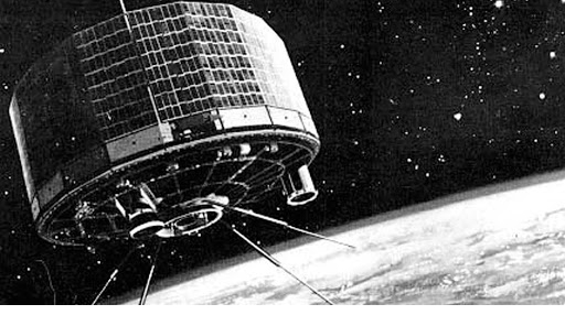
April 1, 2020: Celebrating 60 Years of Weather Satellites
![The TIROS-1 satellite. Credit: NASA]()
The TIROS-1 satellite. Credit: NASA On April 1, 1960, the National Aeronautics and Space Administration (NASA) launched TIROS-1, the world’s first successful meteorological satellite. Since then, NASA and NOAA have worked together to launch satellites that track clouds, oceans, carbon dioxide, atmospheric ozone and more. The latest generation of satellites, GOES-R and JPSS, monitor lightning flashes, hurricanes, wildfires, sea ice, electric lights, solar activity and so much more! These satellites are significantly enhancing our understanding of the Earth as a whole system. A new story map looks at the value and importance of the nation's weather satellites and game-changing moments in their 60-year history.
April
-
March 30, 2020: What Causes a Tornado?
What causes a tornado? The swirling, funnel-shaped winds of a tornado are easily recognizable—and they can be very dangerous. But what causes these unique and violent weather phenomena? A new animated video explains how a tornado forms and also how satellites like GOES-16 help forecasters warn us when severe weather might lead to a tornado. Learn more about tornadoes from our partners at SciJinks.
-
March 19, 2020: Monitoring Earth’s Transition to Spring
Kevin Fryar explains how NOAA satellites monitor Earth’s transition to spring. Spring brings the promise of warmer temperatures, blooming flowers, and more people getting outside after being cooped up all winter. Thanks to NOAA satellites, we can see how Earth sheds its winter coat from space this time of year. From melting snow to greening vegetation, signs of spring are becoming apparent. Satellites also monitor the changing weather patterns that come with the transition from winter to spring. The potential for severe thunderstorms, hail, tornadoes, dangerous lightning, and flooding increases in the spring months. According to NOAA’s 2020 Spring Flood and Climate Outlook, released on March 19, much of the country is looking at above-normal precipitation and an enhanced risk of flooding this spring. GOES-16 (GOES East) and GOES-17 (GOES-West) are equipped to provide detailed information about the atmosphere and clouds in near real-time to help forecasters provide early warnings of hazardous weather.
-
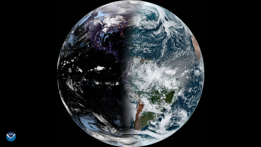
March 19, 2020: Earliest Vernal Equinox in 124 Years
![This image of Earth was taken on March 19, 2020 by GOES-16 (GOES East) in honor of the start of astronomical spring in the Northern Hemisphere]()
This image of Earth was taken on March 19, 2020 by GOES-16 (GOES East) in honor of the start of astronomical spring in the Northern Hemisphere. This year’s vernal equinox is the earliest in 124 Years. The last time the vernal equinox occurred this early was in 1896, so it is the earliest spring anyone alive today has ever experienced—and it will occur even earlier in the future. Why did it occur so early this year? It has to do with leap years. This year, the equinox will occur at 11:49 p.m. EDT, March 19, signifying the start of spring in the Northern Hemisphere and autumn in the Southern Hemisphere. During the precise moment of the equinox, daytime and nighttime will be nearly equal across the entire planet. From that point on, the Northern Hemisphere will experience earlier sunrises and longer daytimes, and the Southern Hemisphere will experience later sunrises and earlier sunsets.
-
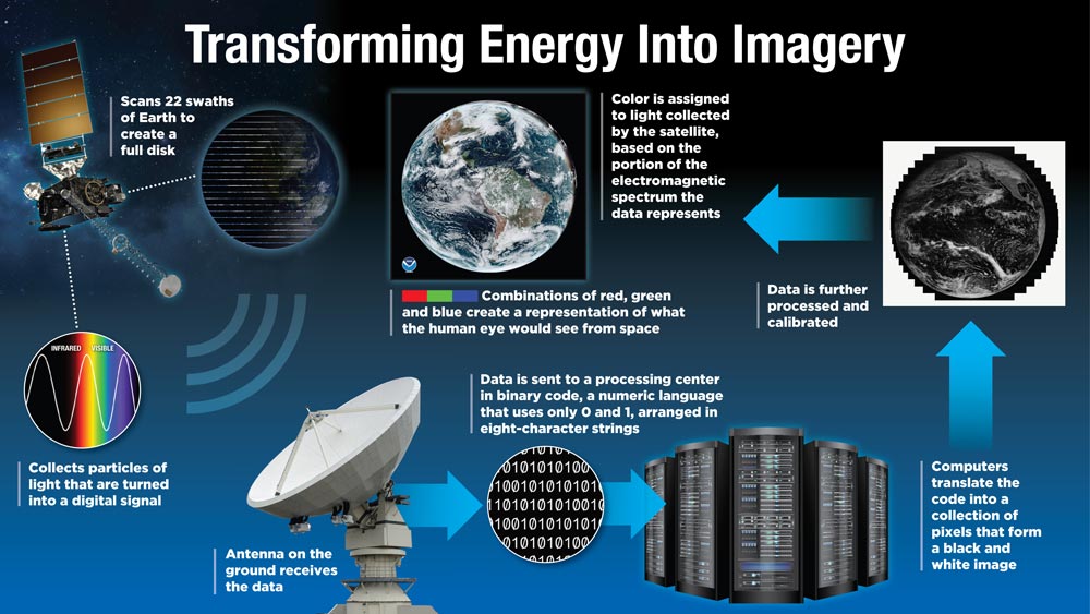
March 10, 2020: Transforming Energy into Imagery
![Process for translating satellite data into imagery. Credit: NOAA]()
Process for translating satellite data into imagery. Credit: NOAA GOES-16 and GOES-17, also known as GOES East and GOES-West respectively, provide beautiful images of Earth. However, what you see on your television, computer, and mobile device are digital representations of the data these satellites capture, not actual photographs or videos. A new feature story explains how satellite data is translated into imagery. A lot goes on behind the scenes to create and deliver this colorful imagery, but these enhancements result in more than just a pretty picture. This vivid imagery conveys complex environmental information from large satellite datasets to highlight the presence and evolution of important meteorological phenomena.
-
March 9, 2020: Tropical Cyclones Are Intensifying More Quickly
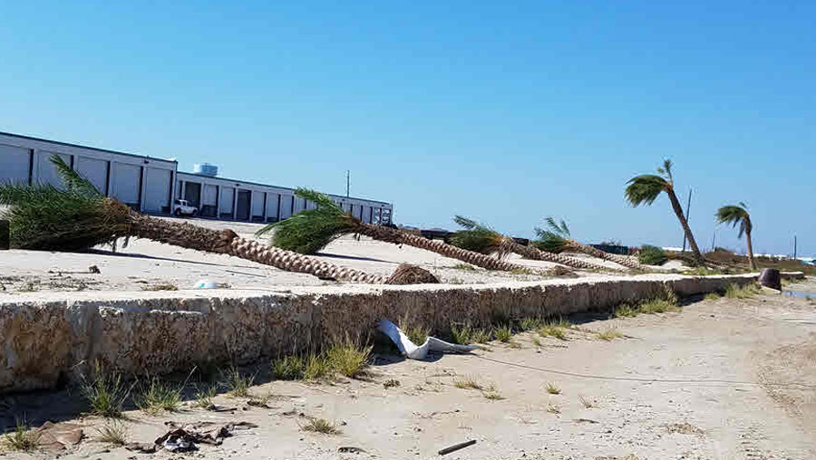
![Beach damaged by a hurricane. Credit: NCEI]()
Beach damaged by a hurricane. Credit: NCEI Hurricanes are growing more powerful more quickly, according to a study of intensification rates by NOAA’s National Centers for Environmental Information (NCEI) and research partners. And these powerful storms cause public health crises that disproportionately impact socioeconomically disadvantaged nations—an instance of “environmental injustice”—described in a Perspective article in the New England Journal of Medicine co-authored by an NCEI scientist.
-
March 3, 2020: 2019 NOAA Science Report
![A wall of intense snowfall descends on Buffalo during the first of two historic back-to-back lake-effect snow events in November 2014]()
A wall of intense snowfall descends on Buffalo during the first of two historic back-to-back lake-effect snow events in November 2014. New NOAA satellite data are helping improve tool to predict severe Great Lakes snowstorms. Credit: Shawn Smith Uncovering never-before-seen deep sea coral habitat, applying machine learning to severe weather warnings and fish survey data, and upgrading the U.S. global weather forecast model — these are just a few of NOAA’s scientific achievements in 2019. The newly-released NOAA Science Report highlights the ways these accomplishments — and many more — provide the foundation for vital services that Americans use every day. The report celebrates NOAA’s vital ocean, weather, Great Lakes, and atmospheric research, and how it works to protect lives and property, support a vibrant economy, and strengthen national security. GOES-16 and GOES-17 data contribute to many NOAA science applications.
March

-
February 28, 2020: GOES-16/17 2020 Virtual Science Fair
![Satellite image of earth]()
Students from grades 6-14 are invited to participate in the GOES-R Education Proving Ground GOES-16/17 2020 Virtual Science Fair. Students will use data from the GOES-16 and GOES-17 satellites to investigate weather and natural hazards. There will one winning team in each of three categories: middle school, high school and grades 13/14 (community college or university). Each team will consist of 2-4 students and 1 teacher/coach per entry. Entries will be accepted March 1 – May 22, 2020.
Students from the winning teams will receive $25 gift cards and official GOES-T launch viewing invitations to Kennedy Space Center (but no travel support). Teachers coaching the winning teams will garner GOES-T launch invites (no travel support) and conference travel support to attend and present at the 2021 American Meteorological Society (AMS) Centennial meeting in New Orleans.
-
February 13, 2020: NOAA Takes Next Step Toward New Ideas for Future Satellites
NOAA has completed a review of the many responses from two Broad Agency Announcements, or BAAs, seeking fresh ideas for new instrument technologies and concepts for future use on its next-generation geostationary, extended orbit, and polar-orbiting weather satellites. NOAA will begin to distribute directed Requests for Proposals (RFPs) to selected entities this week. RFP notifications will continue on a rolling basis for several weeks. As the proposals are received and evaluated, NOAA will determine which companies will receive contracts to conduct short-term, focused studies intended to advance the agency's satellite architecture beyond GOES-R and JPSS.
-
February 7, 2020: National Weather Service at 150: 7 Tech Inventions that Improved Forecasting
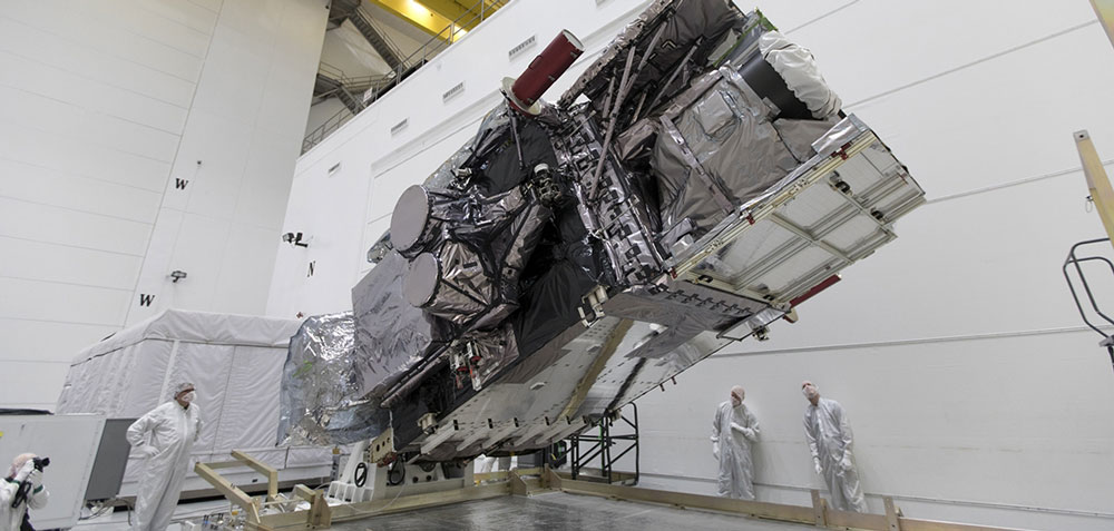
![GOES-S rotated to the vertical position after uncrating at Astrotech Space Operations in Titusville, Florida, so engineers could prepare the satellite for launch.]()
GOES-S rotated to the vertical position after uncrating at Astrotech Space Operations in Titusville, Florida, so engineers could prepare the satellite for launch. What we know today as NOAA’s National Weather Service (NWS) was founded 150 years ago on February 9, 1870 – that’s 15 decades of science and service to the country. Since then, weather forecasting has become far more accurate and timely. As NWS celebrates its 150th birthday, NOAA takes a look at 7 tech advancements that changed the way we do weather forecasting, including weather satellites like GOES-16 and GOES-17.
-
February 7, 2020: Last Year’s Billion-Dollar Disasters Show Crucial Link Between NOAA Satellites and Emergency Managers
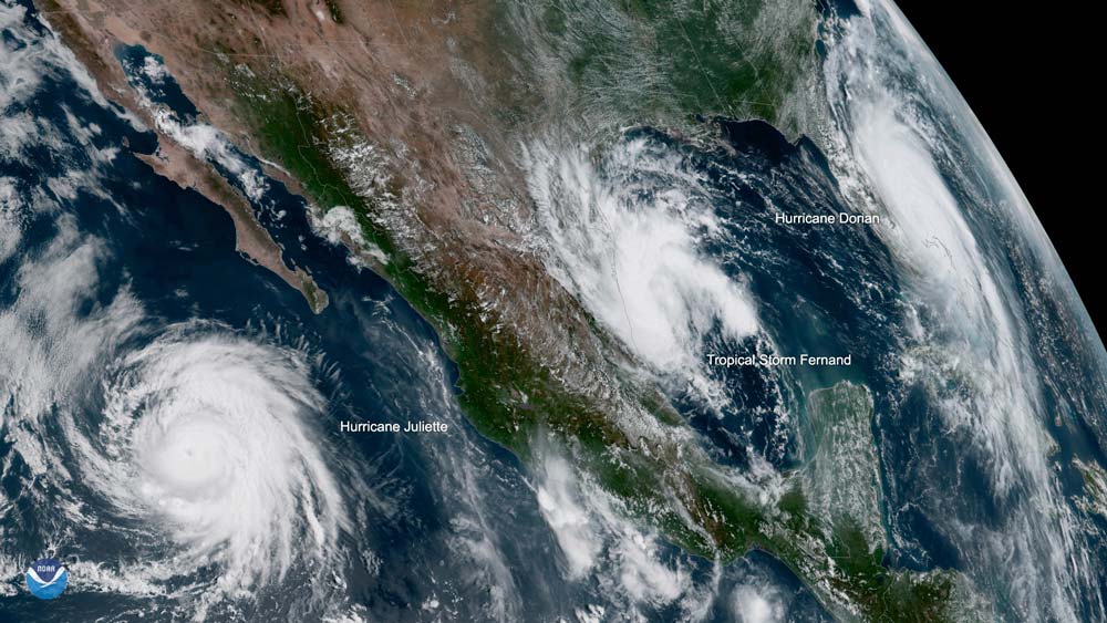
![A view from GOES-17 of three tropical systems in the Eastern Pacific and Atlantic basin in September 2019. From left to right, Hurricane Juliette, Tropical Storm Fernand, and Hurricane Dorian.]()
A view from GOES-17 of three tropical systems in the Eastern Pacific and Atlantic basin in September 2019. From left to right, Hurricane Juliette, Tropical Storm Fernand, and Hurricane Dorian. Although the U.S. saw 14 billion-dollar disasters in 2019, many less-extreme weather and climate events occur regularly. No matter how large or small, NOAA’s satellite imagery and data, including that from GOES-16 and GOES-17, were the foundation of 2019’s forecasts. For federal, state, and local emergency managers, those same satellites provided critical, up-to-the-minute information as well. A new feature story highlights how NOAA satellites bring better data for weather prediction and provide a more comprehensive scope of disasters after they happen.
February

-
January 29, 2020: NESDIS Reflects on 2019
![NESDIS Reflects on 2019]()
2019 was a busy year for NOAA’s National Environmental Satellite, Data, and Information Service (NESDIS). NOAA’s exceptional team of experts helped us understand our dynamic planet. GOES-16 and GOES-17 contributed to a successful 2019 by providing access to secure and timely environmental data. GOES-17 became NOAA’s operational GOES West satellite, providing high-resolution real-time visible and infrared imagery of the west coast of the contiguous U.S., Alaska, Hawaii, and much of the Pacific Ocean. GOES-16 and GOES-17 monitored extreme weather events from hurricanes to wildfires, and kept an eye on the sun during eclipses, solar flares, and the Mercury transit.
-
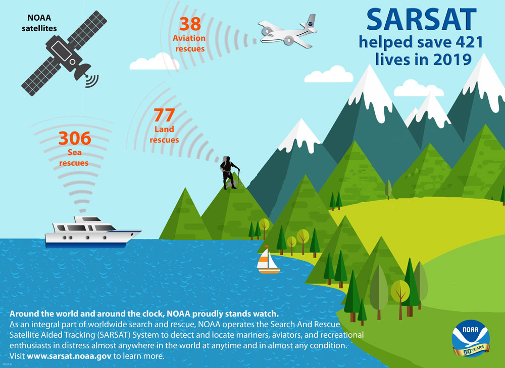
January 23, 2020: NOAA Satellites Helped Save a Record 421 Lives in 2019
![SARSAT rescues for 2019]()
The same NOAA satellites that helped forecasters track weather and wildfires were also critical in rescuing a record 421 people from potentially life-threatening situations throughout the United States and its surrounding waters in 2019. NOAA’s polar-orbiting and geostationary satellites are part of the global Search and Rescue Satellite Aided Tracking System, or COSPAS-SARSAT, which uses a network of U.S. and international spacecraft to detect and locate distress signals from emergency beacons aboard aircraft, boats and from handheld Personal Locator Beacons (PLBs) anywhere in the world. In addition to carrying instruments for monitoring our atmosphere, land and oceans for severe weather and other hazards, GOES-16 and GOES-17 also carry SARSAT transponders to help locate people in distress.
-
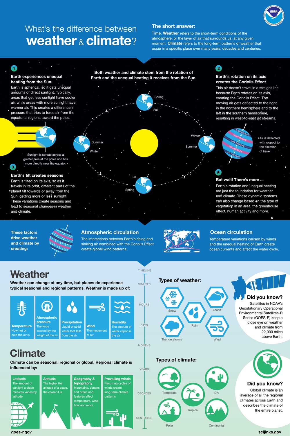
January 21, 2020: What’s the Difference Between Weather and Climate?
![What’s the Difference Between Weather and Climate? image]()
Weather refers to the short-term conditions of the atmosphere at any given time. Climate refers to the long-term patterns of weather that occur in a specific place over many years, decades and centuries. This poster explains the factors that drive weather and climate.
-
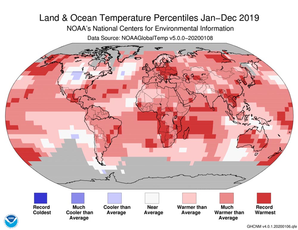
January 15, 2020: 2019 Was the 2nd Hottest Year on Record
![Land and ocean temperature percentiles: Jan – Dec 2019.]()
Land and ocean temperature percentiles: Jan – Dec 2019. Earth’s warming trend continued in 2019, making it the second-hottest year in NOAA’s 140-year climate record just behind 2016. The world’s five warmest years have all occurred since 2015 with nine of the 10 warmest years occurring since 2005, according to scientists from NOAA's National Centers for Environmental Information (NCEI). It was also the 43rd consecutive year with global land and ocean temperatures, at least nominally, above average. NASA scientists, who conducted a separate but similar analysis, concurred with NOAA’s ranking. NASA also found that 2010-2019 was the hottest decade ever recorded.
-
January 13, 2020: 50 Years of Science, Service and Stewardship
![50 Years of Science, Service and Stewardship]()
Guess who’s turning 50 this year? Throughout 2020, NOAA is celebrating 50 years of science, service and stewardship. Since its inception on October 3, 1970, NOAA has become one of the world’s premier science agencies with a mission that spans from the surface of the sun to the floor of the ocean. Our science has never been more important for our lives and our planet. See where we’ve been and where we’re going.
-
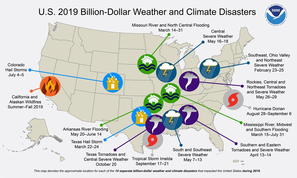
January 8, 2020: Billion-Dollar Weather and Climate Disasters
![2019 Billion-Dollar Weather and Climate Disasters]()
U.S. 2019 Billion-Dollar Weather and Climate Disasters NOAA’s year-end climate analysis was released on January 8, 2019. It was another year of record-making weather and climate for the U.S. in 2019, which was the second wettest behind 1973. The nation also experienced 14 billion-dollar weather and climate disasters. The extreme weather with the most widespread impact was the historically persistent and destructive U.S. flooding across more than 15 states. The combined cost of just the Missouri, Arkansas and Mississippi River basin flooding ($20 billion) was almost half of the U.S. cost total in 2019.
-
January 8, 2020: 4th Quarter 2019 GOES-R Program Newsletter
![NOAA’s Big Data Project]()
GOES-R ground segment personnel celebrate a successful delta System Definition Review/System Requirements Review on November 21, 2019. The GOES-R Series Program quarterly newsletter for October – December 2019 is now available. The GOES-R Program ended 2019 on a high note. GOES-16 and GOES-17 continue operational service, providing critical weather data for the nation. Our team continues to make great progress building GOES-T and U and upgrading our ground system. The Geostationary and Extended Orbits (GEO-XO) program is officially underway, authorized to move into the conceptual phase of the mission. The team looks forward to presenting our work and connecting with colleagues at the upcoming 100th American Meteorological Society Meeting in Boston. Here’s to a productive and successful 2020 for the GOES-R and GEO-XO Programs!
-
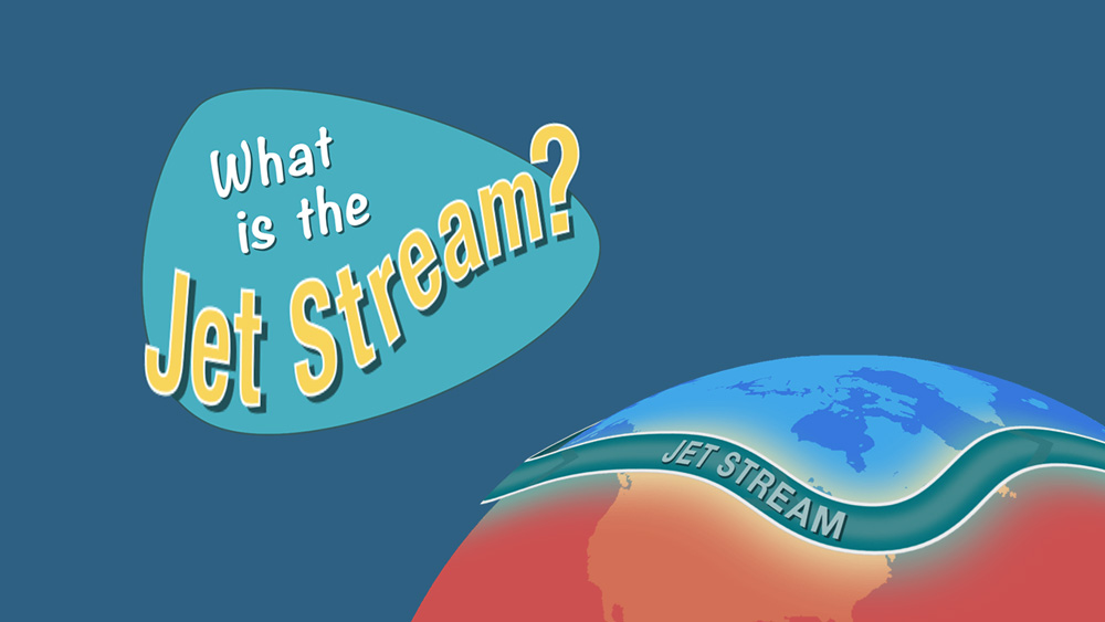
January 6, 2020: What is the Jet Stream?
![NOAA’s Big Data Project]()
Jet streams are bands of strong wind that generally blow from west to east all across the globe. They impact weather, air travel and many other things that take place in our atmosphere. Learn more about the jet stream and how the GOES-R Series monitors jet streams in a new video and article.